
A sundial is a horological device that tells the time of day when direct sunlight shines by the apparent position of the Sun in the sky. In the narrowest sense of the word, it consists of a flat plate and a gnomon, which casts a shadow onto the dial. As the Sun appears to move through the sky, the shadow aligns with different hour-lines, which are marked on the dial to indicate the time of day. The style is the time-telling edge of the gnomon, though a single point or nodus may be used. The gnomon casts a broad shadow; the shadow of the style shows the time. The gnomon may be a rod, wire, or elaborately decorated metal casting. The style must be parallel to the axis of the Earth's rotation for the sundial to be accurate throughout the year. The style's angle from horizontal is equal to the sundial's geographical latitude.
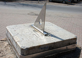
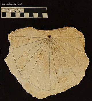
A gnomon is the part of a sundial that casts a shadow. The term is used for a variety of purposes in mathematics and other fields.
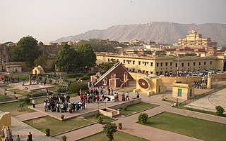
The Jantar Mantar, Jaipur is a collection of 19 astronomical instruments built by the Rajput king Sawai Jai Singh, the founder of Jaipur, Rajasthan. The monument was completed in 1734. It features the world's largest stone sundial, and is a UNESCO World Heritage Site. It is near City Palace and Hawa Mahal. The instruments allow the observation of astronomical positions with the naked eye. The observatory is an example of the Ptolemaic positional astronomy which was shared by many civilizations.

St. Michael and All Angels is the parish church for the town of Middlewich in Cheshire, England. It stands at the junction of the A54 and A533 roads. The church is recorded in the National Heritage List for England as a designated Grade II* listed building. It is an active Anglican parish church in the diocese of Chester, the archdeaconry of Chester and the deanery of Middlewich. Its benefice is combined with that of St John, Byley. In 1947 the architectural historian Raymond Richards described the church as "the one building, in a depressing town, which is mellow and dignified".
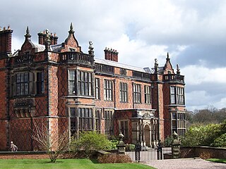
Arley Hall is a country house in the village of Arley, Cheshire, England, about 4 miles (6 km) south of Lymm and 5 miles (8 km) north of Northwich. It is home to the owner, Viscount Ashbrook, and his family. The house is a Grade II* listed building, as is its adjacent chapel. Formal gardens to the southwest of the hall are also listed as Grade II* on the National Register of Historic Parks and Gardens. In the grounds are more listed buildings, a cruck barn being listed as Grade I, and the other buildings as Grade II.

The Church of St Mary the Virgin is in Leek Road, Bosley, Cheshire, England. It is recorded in the National Heritage List for England as a designated Grade II* listed building. It is an active Anglican parish church in the diocese of Chester, the archdeaconry of Macclesfield, and the deanery of Macclesfield. Its benefice is combined with those of St Michael, North Rode, St Michael, Wincle, and St Saviour, Wildboarclough.

St Oswald's Church is north of the village of Brereton Green, adjacent to Brereton Hall, in the civil parish of Brereton, Cheshire, England, on the banks of the River Croco. It is recorded in the National Heritage List for England as a designated Grade II* listed building, and is described as "an unusually complete late Perpendicular church". It is an active Anglican parish church in the diocese of Chester, the archdeaconry of Macclesfield and the deanery of Congleton. Its benefice is combined with those of Christ Church, Eaton, and St Michael, Hulme Walfield.

Man Enters the Cosmos is a cast bronze sculpture by Henry Moore located on the Lake Michigan lakefront outside the Adler Planetarium in the Museum Campus area of downtown Chicago, Illinois.

St John the Baptist's Church is in the village of Guilden Sutton, near Chester, Cheshire, England. It is recorded in the National Heritage List for England as a designated Grade II listed building. It is an active Anglican parish church. The church is in the diocese of Chester, the archdeaconry of Chester and the deanery of Chester. Its benefice is combined with that of St Peter, Plemstall.

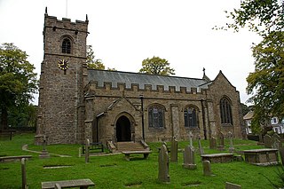
St Michael's Church is in the town of Kirkham, Lancashire, England. The church is recorded in the National Heritage List for England as a designated Grade II* listed building. It is an active Anglican parish church in the diocese of Blackburn, the archdeaconry of Lancaster and the deanery of Kirkham.

St Alkmund's Church is an active Anglican parish church in Whitchurch, Shropshire, England. By tradition, this church was founded in the 900s CE by the Saxon Queen Æthelflæd. Certain sources suggest that the saint to whom it is dedicated, St. Alkmund, (the son of Alhred, King of Northumbria, was first buried in Whitchurch.

Located in Frankfort, Kentucky, overlooking the state capital, Kentucky Vietnam Veterans Memorial contains the names of 1,108 Kentuckians killed in the Vietnam War. The memorial is in the form of a sundial with the names placed so that the tip of the gnomon's shadow touches each man's name on the date of his death, thus giving each fallen warrior his own personal memorial day.
A sundial is a device that indicates time by using a light spot or shadow cast by the position of the Sun on a reference scale. As the Earth turns on its polar axis, the sun appears to cross the sky from east to west, rising at sun-rise from beneath the horizon to a zenith at mid-day and falling again behind the horizon at sunset. Both the azimuth (direction) and the altitude (height) can be used to create time measuring devices. Sundials have been invented independently in every major culture and became more accurate and sophisticated as the culture developed.

Gnomon Island is a small rocky island lying just north of Point Wild, on Elephant Island in the South Shetland Islands. It was charted by Ernest Shackleton's Endurance expedition, 1914–1916, and so named by them because when viewed from Point Wild the shape of the feature is suggestive of a gnomon, the elevated arm of a sundial.

St Michael's Church is located in the settlement of Whittington, Lancashire, England. It is an active Anglican parish church in the deanery of Tunstall, the archdeaconry of Lancaster and the diocese of Blackburn. Its benefice is united with those of St John the Evangelist, Gressingham, St Margaret, Hornby, and St John the Baptist, Arkholme. The church is recorded in the National Heritage List for England as a designated Grade II* listed building.

St Leonard's Church is in the village of Balderstone, Lancashire, England. It is an active Anglican parish church in the deanery of Whalley, the archdeaconry of Blackburn, and the diocese of Blackburn. The church is recorded in the National Heritage List for England as a designated Grade II listed building.

St Mary's Church is in the village of Staveley-in-Cartmel, Cumbria, England. It is an active Anglican parish church in the deanery of Windermere, the archdeaconry of Westmorland and Furness, and the diocese of Carlisle. It is recorded in the National Heritage List for England as a designated Grade II listed building.

St Bartholomew's Church is in the village of Chipping, Lancashire, England. It is an active Anglican parish church in the deanery of Whalley, the archdeaconry of Blackburn, and the diocese of Blackburn. Its benefice is united with that of St Michael, Whitewell. The church is recorded in the National Heritage List for England as a designated Grade II* listed building.
St Leonard's Church is in the village of Downham, Lancashire, England. It is an active Anglican parish church in the diocese of Blackburn. The tower dates from the 15th century, and the rest of the church was rebuilt in 1909–10. The church is recorded in the National Heritage List for England as a designated Grade II* listed building.
A schema for horizontal dials is a set of instructions used to construct horizontal sundials using compass and straightedge construction techniques, which were widely used in Europe from the late fifteenth century to the late nineteenth century. The common horizontal sundial is a geometric projection of an equatorial sundial onto a horizontal plane.


