
Meldreth is a village and civil parish in South Cambridgeshire, England, located around 10 miles (16 km) south-west of Cambridge. At the 2011 Census, the population of the parish was 1,783.

Hartford is a suburb of Huntingdon and former civil parish, now in the parish of Huntingdon, in Cambridgeshire, England. Historically part of Huntingdonshire, it is not far west of Wyton. It lies on the A141 road and on the north bank of the River Great Ouse, upon which it has a significant marina. The village is not to be confused with the much larger town of Hertford, some 38 miles (61 km) to the south-east. In 1931 the parish had a population of 464. On 1 April 1935 the parish was abolished and merged with Huntingdon, part also went to Houghton and Wyton and Kings Ripton.
Adbaston is a village and a civil parish in the English county of Staffordshire.

Wellow is a village in Nottinghamshire, England. According to the 2001 census it had a population of 444, increasing to 470 at the 2011 census, but falling slightly to 463 at the 2021 census.

Morborne is a village and civil parish in Cambridgeshire, England. Morborne lies approximately 5 miles (8 km) south-west of Peterborough, near Yaxley. Morborne is situated within Huntingdonshire which is a non-metropolitan district of Cambridgeshire as well as being a historic county of England. Morborne is a very small village occupying 1205 acres, of which most is arable farmland. The population in 1991 was 43, down from a peak of 122 people in 1851. Local landmarks include Manor Farm, which opens annually each Spring for "Lambing Sunday", and the Church of All Saints. All Saints' is a Grade I listed building.
Wood Walton is a village and civil parish in Cambridgeshire, England. Wood Walton lies approximately 6 miles (10 km) north of Huntingdon and just east of the A1. Wood Walton is situated within Huntingdonshire which is a non-metropolitan district of Cambridgeshire as well as being a historic county of England.
Haddon is a village and civil parish in Cambridgeshire, England. Haddon lies approximately 5 miles (8 km) south-west of Peterborough city centre, near to Chesterton and Yaxley. Haddon is situated within Huntingdonshire which is a non-metropolitan district of Cambridgeshire as well as being a historic county of England.
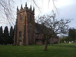
Elton is a village and civil parish in Cambridgeshire, England. Elton lies approximately 7 miles (11 km) south-west of Peterborough. Elton is situated within Huntingdonshire which is a non-metropolitan district of Cambridgeshire as well as being a historic county of England. Elton is a small village within the historic boundaries of Huntingdonshire, England. It lies on the B671 road. Elton Hall and the hamlet of Over End are located on the same road a mile south of the village.

Alpraham is a village and former civil parish, now in the parish of Alpraham and Calveley, in the Cheshire East district, in the ceremonial county of Cheshire, England. It is on the A51 road between Nantwich and Chester, seven miles north-west of Nantwich. The population is around 400.
Judith of Lens was a niece of William the Conqueror. She was a daughter of Lambert II, Count of Lens and Adelaide of Normandy, the sister of William the Conqueror.

Rufford Abbey is a country estate in Rufford, Nottinghamshire, England, two miles (4 km) south of Ollerton. Originally a Cistercian abbey, it was converted to a country house in the 16th century after King Henry VIII’s dissolution of the monasteries. Part of the house was demolished in the 20th century, but the remains, standing in 150 acres of park and woodland, are open to the public as Rufford Country Park. Part of the park is a local nature reserve.
Gilbert de Gant was the son of Ralph, Lord of Aalst near Ghent, and Gisele of Luxembourg, the sister-in-law of Baldwin IV, Count of Flanders. Gilbert de Gant was a kinsman of Matilda of Flanders, wife of William the Conqueror. He had two older brothers, Baldwin and Ralph. Gilbert of Ghent is mentioned in the Domesday Book of 1086 as having been given titles of 172 English manors but also within 14 shires where there were estates including York, Derby, Huntingdonshire, Leicestershire and Cambridgeshire.
Conksbury is the site of a deserted medieval settlement between Over Haddon and Youlgreave in Derbyshire, England.

Semer is a small village and civil parish in Suffolk, England. Located adjacent to a bridge over the River Brett on the B1115 between Hadleigh and Stowmarket, it is part of Babergh district. The parish also contains the hamlets of Ash Street and Drakestone Green.
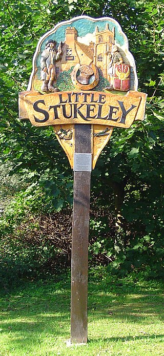
Little Stukeley is a village and former civil parish, now in the parish of The Stukeleys, in Cambridgeshire, England. Little Stukeley lies approximately 3 miles (5 km) north-west of Huntingdon. Little Stukeley is situated within Huntingdonshire which is a non-metropolitan district of Cambridgeshire as well as being a historic county of England. In 1931 the parish had a population of 209.
Chevithorne is a small village near Tiverton, Devon. It lies three miles to the North East of Tiverton. 'Chenetorne' is identified in two entries of the Doomsday Book: The first entry tells us the manor of Chevithorne, had a taxable value 0.6 geld units, and worth £2.3 to the lord in 1086. The holding was populated by 4 villagers. 2 smallholders. 8 slaves. There was enough ploughland for 2 lord's plough teams. and 2 men's plough teams and had, in addition, 0.12 lord's lands. 8 acres of meadow. 15 acres in pasture. and 3 acres of woodland. There were also 10 cattle and 60 sheep. The 'Lords' of this holding in 1086: are named as Alwin, and Beatrix . Ralph de Pomeroy was Tenant-in-chief, He was a large land holder in Devon, and his brother William held several properties as both lord and Tenant-in-Chief.

Milwich is a village and a civil parish in the English county of Staffordshire.
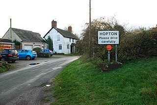
Hopton is a village in the civil parish of Hopton and Coton and is within the English county of Staffordshire.

North Radworthy is a hamlet and historic estate in the civil parish and former manor of North Molton, in the North Devon district of the county of Devon, England. It is about three miles north of the village of North Molton, and about fifteen miles to the east of the town of Barnstaple. The hamlet sits on an unclassified road, and is surrounded to the north, south and west by woodland. North Radworthy Farm is the centre of the historic estate.
Bilsthorpe Moor is a hamlet in the civil parish of Bilsthorpe, in the Newark and Sherwood district of Nottinghamshire, England. It is 120 miles north of London, 13 miles north east of the city of Nottingham, and 5 miles south of Ollerton, and close to the junction of the A614 and A617 roads.
