
The Mattagami River is a river in Northern Ontario, Canada.

Lake Doré is a freshwater lake in the township of North Algona-Wilberforce, Renfrew County, Ontario, Canada, about 6 kilometres (3.7 mi) north of the community of Eganville in the neighbouring township of Bonnechere Valley.
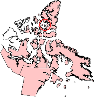
Graham Island is an uninhabited island in Qikiqtaaluk Region, Nunavut, Canada. A member of the Queen Elizabeth Islands and Canadian Arctic Archipelago, it is located in Norwegian Bay off the coast of Ellesmere Island. Located at 77°25'N 90°30'W it has an area of 1,378 km2 (532 sq mi), 55 kilometres (34 mi) long and 40 kilometres (25 mi) wide. It was named in 1910.

Crawford Lake Conservation Area is a conservation area owned and operated by Conservation Halton near the community of Campbellville in Milton, Halton, Ontario, Canada. It is categorized as a regional environmentally sensitive area, an Ontario Area of Natural and Scientific Interest, and part of the Niagara escarpment world biosphere reserve. The conservation area contains Crawford Lake, a reconstructed Iroquoian village, and several hiking trails.

The Bolton River is a river in the Hudson Bay drainage basin in Census Division No. 22 - Thompson-North Central, Northern Region, Manitoba, Canada. It is about 115 kilometres (71 mi) long and begins at Musketasonan Lake, about 20 kilometres (12 mi) south of Molson Lake, at an elevation of 249 metres (817 ft). It flows northeast through Little Bolton Lake at an elevation of 224 metres (735 ft), Rushforth Lake at an elevation of 218 metres (715 ft), Bolton Lake at an elevation of 212 metres (696 ft), where it takes in the right tributary Nikik River, and Kakwusis Lake at an elevation of 208 metres (682 ft). The river continues northeast over the twin Kasukwapiskechewak Rapids, then over the twin Kakwu Rapids, and empties into Aswapiswanan Lake at an elevation of 186 metres (610 ft), about 60 kilometres (37 mi) west southwest of the community of Gods Lake Narrows. The Bolton River's waters eventually flow into Gods Lake, and via the Gods River and the Hayes River into Hudson Bay.

Bolton Lake is a lake in the James Bay drainage basin in the municipality of Black River-Matheson in Cochrane District, Ontario, Canada. It is about 1,200 metres (3,937 ft) long and 800 metres (2,625 ft) wide, and lies at an elevation of 288 metres (945 ft) near the community of Wavell, 1.3 kilometres (0.8 mi) northeast of Ontario Highway 11 and the Ontario Northland Railway main line, and 33 kilometres (21 mi) northwest of the town of Kirkland Lake. The primary outflow is Burdick creek to the Black River, which flows via the Abitibi River and the Moose River to James Bay.
Blue Jay Creek is a river on Manitoulin Island in Central Manitoulin and Tehkummah townships, Manitoulin District in northeastern Ontario, Canada and a tributary of Lake Huron.
Botsford Lake is a lake in the Hudson Bay drainage basin in Kenora District in northwestern Ontario, Canada. It is about 15 kilometres (9 mi) long and 2.2 kilometres (1.4 mi) wide, is at an elevation of 357 metres (1,171 ft), and lies between the settlements of Superior Junction and McDougall Mills; Rosnel is on the south shore of the lake. The CN transcontinental rail line travels the along the entire south shore. Highway 642 runs west of the lake, and Highway 516 runs approximately parallel to the north shore of the lake at a distance of about 6 kilometres (4 mi).
Tripoli Lake is a lake in the Lake Superior drainage basin in Algoma District, northeastern Ontario, Canada. It is about 2.1 kilometres (1.3 mi) long and 0.9 kilometres (0.6 mi) wide and lies at an elevation of 422 metres (1,385 ft). The Canadian Pacific Railway transcontinental main line passes at the southwest tip of the lake.
West Tripoli Lake is a lake in the Lake Superior drainage basin in Algoma District, northeastern Ontario, Canada. It is about 2.5 kilometres (1.6 mi) long and 0.6 kilometres (0.4 mi) wide and lies at an elevation of 424 metres (1,391 ft). The Canadian Pacific Railway transcontinental main line passes at the northeast tip of the lake.
Upper Summit Lake is a lake in Regional District of Fraser-Fort George, in the Central Interior of British Columbia, Canada, about 40 kilometres (25 mi) north of the city of Prince George and 20 kilometres (12 mi) south of the community of Bear Lake. It lies just west of Highway 97.
Norway Lake is a lake in the Moira River and Lake Ontario drainage basins in Addington Highlands, Lennox and Addington County, Ontario, Canada.
Crawford Lake is a lake in the Albany River drainage basin in Cochrane District, Ontario, Canada. It is about 1.56 kilometres (0.97 mi) long and .81 kilometres (0.50 mi) wide, and lies at an elevation of 169 metres (554 ft). The primary outflow is an unnamed creek which flows via the Cheepay River and the Albany River to James Bay.
Crawford Lake is a lake in the Magnetawan River drainage basin in the township of Magnetawan, Almaguin Highlands region, Parry Sound District, Ontario, Canada. It is about 1.7 kilometres (1.1 mi) long and 1 kilometre (0.6 mi) wide, and lies at an elevation of 279 metres (915 ft). The primary inflows are the Neighick River and Wylie Creek. The primary outflow is a channel to Beaver Lake, which flows via The Narrows channel into Ahmic Lake on the Magnetawan River, and thence into Lake Huron.
Crawford Lake is a lake in the Moose River drainage basin in Sudbury District, Ontario, Canada. It is about 0.7 kilometres (0.4 mi) long and 0.5 kilometres (0.3 mi) wide, and lies at an elevation of 361 metres (1,184 ft) about 10 kilometres (6 mi) south of Ontario Highway 101 and 27 kilometres (17 mi) west of Ontario Highway 144.
Crawford Lake is a lake in the Montreal River and Ottawa River drainage basins in Timiskaming District, Ontario, Canada. It is about 0.87 kilometres (0.5 mi) long and 0.62 kilometres (0.4 mi) wide, and lies at an elevation of 374 metres (1,227 ft) about 7 kilometres (4 mi) southwest of the community of Gowganda. The primary outflow, at the northeast, is an unnamed creek to Long Lake, which flows via Gowganda Lake and the Montreal River to Lake Timiskaming on the Ottawa River.
Crawford Lake is a lake in the Montreal River and Ottawa River drainage basins in Timiskaming District, Ontario, Canada. It is about 0.63 kilometres (0.4 mi) long and 0.2 kilometres (0.1 mi) wide, and lies at an elevation of 348 metres (1,142 ft) about 8 kilometres (5 mi) northeast of the community of Gowganda. A short unnamed creek flows in at the north. The primary outflow, at the south, is an unnamed creek towards Lost Lake, which flows via Calcite Creek, Sydney Creek and the Montreal River to Lake Timiskaming on the Ottawa River.
Montreal Lake is a lake in the Lake Superior drainage basin in Sudbury District, Ontario, Canada, and the source of the Montreal River. It is about 1.5 kilometres (0.9 mi) long and 0.7 kilometres (0.4 mi) wide, and lies at an elevation of 447 metres (1,467 ft) on the north side of the community of Island Lake. The primary outflow, at the east, is the Montreal River, which flows to Lake Superior at Montreal River Harbour.
Molson Lake is a lake in Northern Region, Manitoba, Canada and the source of the Hayes River. It is located about 60 kilometres (37 mi) northeast of the community of Norway House.


