
Lake Michigan is one of the five Great Lakes of North America. It is the second-largest of the Great Lakes by volume and the third-largest by surface area, after Lake Superior and Lake Huron. To the east, its basin is conjoined with that of Lake Huron through the 3+1⁄2-mile (5.6-kilometer) wide, 295-foot deep Straits of Mackinac, giving it the same surface elevation as its easterly counterpart; geologically, the two bodies are a single lake that is, by area, the largest freshwater lake in the world.

Vilas County is a county in the state of Wisconsin, United States. As of the 2020 census, the population was 23,047. Its county seat is Eagle River. The county partly overlaps the reservation of the Lac du Flambeau Band of Lake Superior Chippewa.

Oneida County is a county in the state of Wisconsin, United States. At the 2020 census, the population was 37,845. Its county seat is Rhinelander.
Boulder Junction is a town in Vilas County, Wisconsin, United States. The population was 956 at the 2018 census.

Conover is a town in Vilas County, Wisconsin, United States. The population was 1,235 at the 2010 census. The unincorporated community of Conover is located in the town.

Lake Winnebago is a shallow freshwater lake in the north central United States, located in east central Wisconsin. At 137,700 acres, it is the largest lake entirely within the state, covering an area of about 30 miles by 10 miles with 88 miles of shoreline, an average depth of 15.5 feet, and a maximum depth of 21 feet. It has many shallow reefs along the west shore and a drop-off type shoreline on the east. There are several islands along the west shore.

The Chequamegon–Nicolet National Forest is a 1,530,647-acre (6,194.31 km2) U.S. National Forest in northern Wisconsin in the United States. Due to logging in the early part of the 20th century, very little old growth forest remains. Some of the trees there were planted by the Civilian Conservation Corps in the 1930s. The national forest land trees and vegetation are part of the North Woods Ecoregion that prevails throughout the upper Great Lakes region.
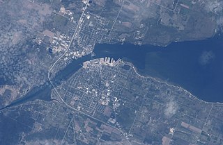
Sturgeon Bay is an arm of Green Bay extending southeastward approximately 10 miles into the Door Peninsula at the city of Sturgeon Bay, located approximately halfway up the Door Peninsula. The bay is connected to Lake Michigan by the Sturgeon Bay Ship Canal. The Potawatomi name for Sturgeon Bay is "Na-ma-we-qui-tong".

The Wolf River is a 225 mi (362 km) long tributary of the Fox River in northeastern Wisconsin in the Great Lakes region of the United States. The river is one of the two National Scenic Rivers in Wisconsin, along with the St. Croix River. The scenic portion is 24 miles (39 km) long. The river and its parent the Fox River and associated lakes are known for their sturgeon which spawn every spring upstream on the lower river until blocked by the Shawano Dam. The river flows through mostly undeveloped forestland southerly from central Forest County in the north to Lake Poygan in the south. The lake is part of the Winnebago Pool of lakes fed by both the Fox and Wolf Rivers. The Fox-Wolf basin is usually considered to be a single unified basin and the rivers themselves may be referred to as the Fox-Wolf River system.

The Door Peninsula is a peninsula in eastern Wisconsin, separating the southern part of the Green Bay from Lake Michigan. The peninsula includes northern Kewaunee County, northeastern Brown County, and the mainland portion of Door County. It is on the western side of the Niagara Escarpment. Well known for its cherry and apple orchards, the Door Peninsula is a popular tourism destination. With the 1881 completion of the Sturgeon Bay Ship Canal, the northern half of the peninsula became an island.
Lac Vieux Desert is a lake in the United States divided between Gogebic County, Michigan, and Vilas County, Wisconsin. Fed primarily by springs in the surrounding swamps, it is the source of the Wisconsin River, which flows out of its southwest corner. The lake contains a number of small islands, especially in its northeastern lobe, including Draper Island, in Michigan, and Duck Island, in Wisconsin.
Wisconsin's 7th congressional district is a congressional district of the United States House of Representatives in northwestern and central Wisconsin; it is the largest congressional district in the state geographically, covering 20 counties, for a total of 18,787 sq mi. The district contains the following counties: Ashland, Barron, Bayfield, Burnett, St. Croix, Chippewa (partial), Clark, Douglas, Florence, Forest, Iron, Jackson (partial), Juneau (partial), Langlade, Lincoln, Marathon, Monroe (partial), Oneida, Polk, Price, Rusk, Sawyer, Taylor, Vilas, Washburn, and Wood (partial).
Lost Lake is located in the town of St. Germain, in Vilas County, Wisconsin, United States. It is 544 acres (2.20 km2) in size and has a maximum depth of 22 feet (6.7 m). Visitors have access to the lake from a public boat landing. Fish include Musky, Panfish, Largemouth Bass, Northern Pike and Walleye.
Star Lake is a lake in Vilas County, Wisconsin, United States. The lake covers an area of 1,206 acres (4.88 km2) and reaches a maximum depth of 68 ft (21 m). Visitors have access to the lake from public boat landings. The community of Star Lake, Wisconsin is located on the lake's northeast shore. Fish species enzootic to Star Lake include bluegill, largemouth bass, muskellunge, northern pike, smallmouth bass, and walleye.

Trout Lake is in Vilas County, Wisconsin, near the towns of Boulder Junction and Arbor Vitae, Wisconsin. With a surface area of 6.208 sq mi (16.079 km2) and a volume of 0.058 cu mi (0.240 km3), Trout Lake is one of the largest lakes in Vilas County. It has 16.1 mi (25.9 km) of shoreline, a large portion of which is undeveloped. There are also seven islands within the lake: Miller Island, Zimmerman Island, Haunted Island, Easter Island, Fisk Island, Chocolate Drop Island, and an unnamed island. It is a dimictic oligotrophic lake that supports a large number of sport fish, which has made it a popular angling destination.

Beaver Dam Lake is a 6,718 acre lake in Dodge County, Wisconsin. The communities of Beaver Dam, South Beaver Dam, Sunset Beach, Beaver Edge, Fox Lake Junction border the lake. The fish present in the lake are Panfish, Largemouth Bass, Northern Pike, and Walleye. The lake is created by a dam located in the City of Beaver Dam at Haskell Street and flows into the Beaver Dam River. There are seven public boat landings and numerous parks along the lake shore.
Fence Lake is a 3,483 acre lake in Vilas County, Wisconsin. The communities of Marlands and Lac du Flambeau border the lake. The fish present in the lake are Muskellunge, Panfish, Largemouth Bass, Smallmouth Bass, Northern Pike, Trout and Walleye.
Ike Walton Lake is a 1,417 acre lake in Vilas County, Wisconsin. The fish present in the lake are Muskellunge, Panfish, Largemouth Bass, Smallmouth Bass, and Walleye. There is one boat ramp in a small bay on the western shore.

Flambeau Lake is a 1,166 acre lake in Vilas County, Wisconsin, USA. The community of Lac du Flambeau completely surrounds the lake. Fish present in the lake are muskellunge, largemouth bass, smallmouth bass, northern pike and walleye. There is one boat ramp on the northeast shore, accessible from Highway 47. It has a maximum depth of 78 feet. Visitors have access to the lake from a public boat landing. Fish include Musky, Panfish, Largemouth Bass, Smallmouth Bass, Northern Pike and Walleye.
Fox Lake is a 2,713 acre lake in Dodge County, Wisconsin. The City of Fox Lake, and the communities of Lyndon Dale and Delbern Acres are found along the shoreline. There are two boat landings that are open to the public, found in parks on the northwest and southeast sides of the lake. Fish present in the lake are Panfish, Muskellunge, Largemouth Bass, Northern Pike, and Walleye. Fox Lake is split by the peninsula, that the community of Lyndon Dale is located on, in the south end of the lake. This forms a bay known as The Jug, near the City of Fox Lake. According to the DNR, the bottom of the lake is 1% sand, 30% gravel, and 69% muck. The lake goes through the Fox Lake Dam, into Mill Creek, then flows to Beaver Dam Lake. The Fox Lake Correctional Institution is less than a mile from the north shore of the lake.

