| Creag Dhubh | |
|---|---|
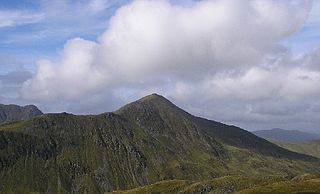
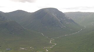
 Creag Dhubh from Glen Spean | |
| Highest point | |
| Elevation | 658 m (2,159 ft) [1] |
| Prominence | 332 m (1,089 ft) |
| Listing | Graham, Marilyn |
| Geography | |
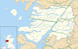
| Location | Lochaber, Scotland |
| Parent range | Grampian Mountains |
| OS grid | NN322824 |
| Topo map | OS Landranger 34, 41 |
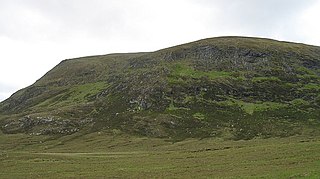
Creag Dhubh (658 m) is a hill in the Grampian Mountains of Scotland. It is located in the Lochaber region, east of Roybridge.

The Grampian Mountains are one of the three major mountain ranges in Scotland, occupying a considerable portion of the Scottish Highlands in northern Scotland. The other major mountain ranges in Scotland are the Northwest Highlands and the Southern Uplands. The Grampian range extends southwest to northeast between the Highland Boundary Fault and the Great Glen, occupying almost half of the land area of Scotland and including the Cairngorms and the Lochaber hills. The range includes many of the highest mountains in the British Isles, including Ben Nevis and Ben Macdui.

Lochaber is a name applied to areas of the Scottish Highlands. Historically, it consisted of the parishes of Kilmallie and Kilmonivaig, as they were before being reduced in extent by the creation of Quoad Sacra parishes in the 19th century; this Lochaber extended from the Northern shore of Loch Leven, a district called Nether Lochaber, to beyond Spean Bridge and Roy Bridge, which area is known as Brae Lochaber or Braigh Loch Abar in Gaelic. The town of Fort William is the main town and Lochaber was a distinct Province of Scotland in its own right. Lochaber is now also used to refer to a much wider area, one of the 16 ward management areas of the Highland Council of Scotland and one of eight former local government districts of the two-tier Highland region.
Roybridge is a small village, that lies at the confluence of the rivers River Roy and River Spean, located 3 miles east of Spean Bridge, in Kilmonivaig Parish, Inverness-shire, Scottish Highlands and is in the Highland administrative area.
A rounded hill, Creag Dhubh separates Glen Spean to the south and lower Glen Roy to the north. [2]

The River Spean flows from Loch Laggan in a westerly direction to join the River Lochy at Gairlochy in the Great Glen in the West Highlands of Scotland. Major tributaries of the Spean include the left-bank Abhainn Ghuilbinn and River Treig, the right-bank River Roy and the left-bank river known as The Cour. The river is accompanied by the A86 road for almost its entire length, running from (upper) Loch Laggan west to Spean Bridge. The river is spanned by a bridge carrying the A82 road near its junction with the A86 at Spean Bridge. A minor road bridges the Spean just above the falls at Inverlair. Two further road crossings exist - a private estate road across the short stretch of river between upper Loch Laggan and the Laggan reservoir and a road traversing the top of Laggan Dam. The West Highland Line crosses the river near Tulloch Station and follows its north bank before re-crossing a mile to the east of Spean Bridge. A branch of the railway formerly continued west beside the river from Spean Bridge, crossing it once again to the west of the village.

Glen Roy in the Lochaber area of the Highlands of Scotland is a national nature reserve noted for the geological puzzle of the three roads. The "Parallel Roads" of Glen Roy are loch terraces that formed along the shorelines of an ancient ice-dammed loch. The loch existed during a brief period of climatic deterioration, during a much longer period of deglaciation, subsequent to the last main ice age. From a distance they resemble man-made roads running along the side of the Glen, hence the name.