A glacier is a persistent body of dense ice that is constantly moving downhill under its own weight. A glacier forms where the accumulation of snow exceeds its ablation over many years, often centuries. It acquires distinguishing features, such as crevasses and seracs, as it slowly flows and deforms under stresses induced by its weight. As it moves, it abrades rock and debris from its substrate to create landforms such as cirques, moraines, or fjords. Although a glacier may flow into a body of water, it forms only on land and is distinct from the much thinner sea ice and lake ice that form on the surface of bodies of water.

Mount Kilimanjaro is a dormant volcano in Tanzania. With three volcanic cones — Kibo, Mawenzi and Shira — it is the highest mountain in Africa and the highest single free-standing mountain above sea level in the world: 5,895 m (19,341 ft) above sea level and 4,900 m (16,100 ft) above its plateau base. It is also the highest volcano in the Eastern Hemisphere.
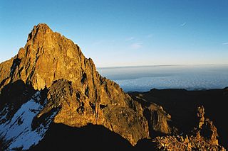
Mount Kenya is an extinct volcano in Kenya and the second-highest peak in Africa, after Kilimanjaro. The highest peaks of the mountain are Batian, Nelion and Point Lenana. Mount Kenya is located in the former Eastern and Central provinces of Kenya; its peak is now the intersection of Meru, Embu, Kirinyaga, Nyeri and Tharaka Nithi counties, about 16.5 kilometres south of the equator, around 150 km (90 mi) north-northeast of the capital Nairobi. Mount Kenya is the source of the name of the Republic of Kenya.

The Last Glacial Period (LGP), also known as the Last glacial cycle, occurred from the end of the Last Interglacial to the beginning of the Holocene, c. 115,000 – c. 11,700 years ago, and thus corresponds to most of the timespan of the Late Pleistocene.

Mount Melbourne is a 2,733-metre-high (8,967 ft) ice-covered stratovolcano in Victoria Land, Antarctica, between Wood Bay and Terra Nova Bay. It is an elongated mountain with a summit caldera filled with ice with numerous parasitic vents; a volcanic field surrounds the edifice. Mount Melbourne has a volume of about 180 cubic kilometres (43 cu mi) and consists of tephra deposits and lava flows; tephra deposits are also found encased within ice and have been used to date the last eruption of Mount Melbourne to 1892 ± 30 years. The volcano is fumarolically active.

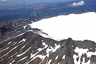
Mount Takahe is a 3,460-metre-high (11,350 ft) snow-covered shield volcano in Marie Byrd Land, Antarctica, 200 kilometres (120 mi) from the Amundsen Sea. It is a c. 30-kilometre-wide (19 mi) mountain with parasitic vents and a caldera up to 8 kilometres (5 mi) wide. Most of the volcano is formed by trachytic lava flows, but hyaloclastite is also found. Snow, ice, and glaciers cover most of Mount Takahe. With a volume of 780 km3 (200 cu mi), it is a massive volcano; the parts of the edifice that are buried underneath the West Antarctic Ice Sheet are probably even larger. It is part of the West Antarctic Rift System along with 18 other known volcanoes.

Pine Island Glacier (PIG) is a large ice stream, and the fastest melting glacier in Antarctica, responsible for about 25% of Antarctica's ice loss. The glacier ice streams flow west-northwest along the south side of the Hudson Mountains into Pine Island Bay, Amundsen Sea, Antarctica. It was mapped by the United States Geological Survey (USGS) from surveys and United States Navy (USN) air photos, 1960–66, and named by the Advisory Committee on Antarctic Names (US-ACAN) in association with Pine Island Bay.

Lonnie Thompson, is an American paleoclimatologist and university professor in the School of Earth Sciences at Ohio State University. He has achieved global recognition for his drilling and analysis of ice cores from ice caps and mountain glaciers in the tropical and sub-tropical regions of the world. He and his wife, Ellen Mosley-Thompson, run the ice core paleoclimatology research group at the Byrd Polar Research Center.

The retreat of glaciers since 1850 is well documented and is one of the effects of climate change. The retreat of mountain glaciers provide evidence for the rise in global temperatures since the late 19th century. Examples include mountain glaciers in western North America, Asia, the Alps in central Europe and tropical and subtropical regions of South America and Africa. Since glacial mass is affected by long-term climatic changes, e.g., precipitation, mean temperature, and cloud cover, glacial mass changes are one of the most sensitive indicators of climate change. Retreat of glaciers is also a major reason for sea level rise. Excluding peripheral glaciers of ice sheets, the total cumulated global glacial losses over the 26-year period from 1993 to 2018 were likely 5500 gigatons, or 210 gigatons per yr.

Furtwangler Glacier is located near the summit of Mount Kilimanjaro in Tanzania. The glacier is named after Walter Furtwängler who, with Siegfried König, formed the fourth party to ascend to the summit of Kilimanjaro in 1912.
Sollipulli is an ice-filled volcanic caldera and volcanic complex, which lies southeast of the small town of Melipeuco in the La Araucanía Region, Chile. It is part of the Southern Volcanic Zone of the Andes, one of the four volcanic belts in the Andes chain.

Arrow Glacier is located near the summit of Mount Kilimanjaro in Tanzania, on the west slope of the peak and is a small remnant of an icecap which once crowned the summit of Mount Kilimanjaro. The glacier is situated at an elevation of between 5,470 and 5,300 metres. Arrow Glacier is adjacent to a climbing route known as the Western Breach/Arrow Glacier Route or more commonly, the Lemosho Route. Arrow Glacier is a recently named glacial remnant that may not even exist as of 2011. It was what remained of an earlier glacier known as the Little Barranco Glacier.
Barranco Glacier is near the summit of Mount Kilimanjaro in Tanzania, on the southwest slope of the peak and is a small remnant of an icecap which once crowned the top of Mount Kilimanjaro. The glacier is situated at an elevation of between 5,200 and 4,800 metres. The Great Barranco Glacier was far larger when first documented in the late 19th century and it along with the now extinct Little Barranco Glacier may have been fed by the Furtwängler Glacier which is on the top of the mountain. By 2011, Barranco Glacier was reduced to two small disconnected and dormant ice bodies.
Drygalski Glacier was on Mount Kilimanjaro in Tanzania, on the northwest slope of the peak. The glacier terminus once extended to an elevation of 4,800 metres (15,700 ft) with an origination point near the summit of Mount Kilimanjaro and was fed by the Northern Ice Field. The Great Penck Glacier once flanked Drygalski Glacier to the south and until recently, the Credner Glacier did as well to the north. Drygalski Glacier is named for German geographer Erich von Drygalski.
Great Penck Glacier was on Mount Kilimanjaro in Tanzania, on the west slope of the peak. Extending from the Northern Ice Field, the glacier once flowed 2.4 kilometres (1.5 mi), to an elevation of 4,750 metres (15,580 ft). Between the years 1962 and 1975, Great Penck Glacier separated from the Northern Icefield and disappeared. Drygalski Glacier once also existed to the north of Great Penck, while the same is true of the Little Penck Glacier, which was to the south.
Little Penck Glacier is on Mount Kilimanjaro in Tanzania, on the west slope of the peak. Once extending from the Northern Ice Field, the glacier detached from the icefield by 1992. A sizeable but stagnant ice body remains near the 1912 historical terminal end of the glacier. The now vanished Great Penck and Uhlig Glaciers once flanked Little Penck Glacier to the north and south, respectively.
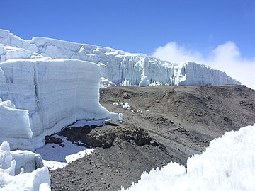
The Northern Ice Field is near the summit of Mount Kilimanjaro in Tanzania, on the west slope of the peak. The Northern Ice Field and Eastern Ice Fields were connected to the Southern Ice Field and formed part of a continuous body of glacial ice atop Mount Kilimanjaro when first scientifically examined in 1912. By 1962 the Southern Ice Field separated from the Northern Ice Field and then by 1975 the Eastern Ice Field did as well. In 1912, the glaciated areas atop Mount Kilimanjaro covered 11.40 square kilometres (4.40 sq mi); by 2011 this had been reduced to 1.76 square kilometres (0.68 sq mi), an 85 percent loss. At one time, ice flowing off the Northern Ice Field fed numerous glaciers, including, north to south, the Credner, Drygalski, Great Penck and Little Penck Glaciers.

Mount Erciyes, also known as Argaeus, its etymon, is an inactive volcano in Kayseri Province, Turkey. It is a large stratovolcano surrounded by many monogenetic vents and lava domes, and one maar. The bulk of the volcano is formed by lava flows of andesitic and dacitic composition. At some time in the past, part of the summit collapsed towards the east.
 Credner Glacier and recently exposed old lava in 2009
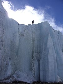 Scientist atop Credner Glacier in 2009