
The San Luis Valley is a region in south-central Colorado with a small portion overlapping into New Mexico. The Rio Grande with headwaters in the San Juan Mountains about seven miles east of Silverton, Colorado flows through the San Luis Valley and then south into New Mexico. It contains 6 counties and portions of 3 others. The San Luis Valley was ceded to the United States by Mexico following the Mexican–American War. Hispanic settlers began moving north and settling in the valley after the United States made a treaty with the Utes and established a fort. Prior to the Mexican war the Spanish and Mexican governments had reserved the valley to the Utes, their allies. During the 19th century Anglo settlers settled in the valley and engaged in mining, ranching, and irrigated agriculture. Today the valley has a diverse Anglo and Hispanic population.

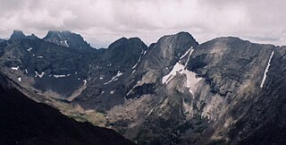
The Sangre de Cristo Range is a mountain range of the Rocky Mountains in southern Colorado in the United States, running north and south along the east side of the Rio Grande Rift. The mountains extend southeast from Poncha Pass for about 75 mi (121 km) through south-central Colorado to La Veta Pass, approximately 20 mi (32 km) west of Walsenburg, and form a high ridge separating the San Luis Valley on the west from the watershed of the Arkansas River on the east. The Sangre de Cristo Range rises over 7,000 ft (2,100 m) above the valleys and plains to the west and northeast.
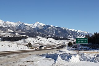
Saguache County is a county located in the U.S. state of Colorado. As of the 2010 census, the population was 6,108. The county seat is Saguache.
The Town of Hooper is a Statutory Town located in the San Luis Valley in Alamosa County, Colorado, United States. The population was 103 at the 2010 census.

Great Sand Dunes National Park and Preserve is an American national park that conserves an area of large sand dunes up to 750 feet (230 m) tall on the eastern edge of the San Luis Valley, and an adjacent national preserve in the Sangre de Cristo Range, in south-central Colorado, United States. The park was originally designated Great Sand Dunes National Monument on March 17, 1932, by President Herbert Hoover. The original boundaries protected an area of 35,528 acres. A boundary change and redesignation as a national park and preserve was authorized on November 22, 2000, and then established on September 24, 2004. The park encompasses 107,342 acres while the preserve protects an additional 41,686 acres for a total of 149,028 acres. The recreational visitor total was 527,546 in 2019.

The Sangre de Cristo Mountains are the southernmost subrange of the Rocky Mountains. They are located in southern Colorado and northern New Mexico in the United States. The mountains run from Poncha Pass in South-Central Colorado, trending southeast and south, ending at Glorieta Pass, southeast of Santa Fe, New Mexico. The mountains contain a number of fourteen thousand foot peaks in the Colorado portion, as well as all the peaks in New Mexico which are over twelve thousand feet.

The Baca National Wildlife Refuge is a 78,697-acre (31,848 ha) United States National Wildlife Refuge located in southern Colorado. It is within the Sangre de Cristo National Heritage Area.

The Paul Winter Consort is an American musical group, led by soprano saxophonist Paul Winter. Founded in 1967, the group mixes elements of jazz, classical music, world music, and the sounds of animals and nature. They are often classified as "new age" or "ecological jazz", and their musical style is often called "Earth Music". The group has had many lineup changes since it was founded. Long-standing members currently in the group include Paul Winter, cellist Eugene Friesen, Berklee alumnus bassist Eliot Wadopian, jazz oboist Paul McCandless, and percussionist and frame drum specialist Glen Velez. Past members who were part of the group for a considerable length of time include Paul Halley, Susan Osborn, Oscar Castro-Neves, Russ Landau, David Darling, Jim Scott, Dorothy Papadakos, and Rhonda Larson.
Kit Carson Peak is a high mountain summit of the Crestones in the Sangre de Cristo Range of the Rocky Mountains of North America. Officially designated Kit Carson Mountain, the 14,171-foot (4,319 m) fourteener is located 5.2 miles (8.4 km) east by south of the Town of Crestone in Saguache County, Colorado, United States. The name Kit Carson Mountain is used for both the massif with three summits, or to describe the main summit only. The mountain is named in honor of frontiersman Christopher Houston "Kit" Carson. The Crestones are a cluster of high summits in the Sangre de Cristo Range, comprising Crestone Peak, Crestone Needle, Kit Carson Peak, Challenger Point, Humboldt Peak, and Columbia Point. They are usually accessed from common trailheads.

Crestone Needle is a high mountain summit of the Crestones in the Sangre de Cristo Range of the Rocky Mountains of North America. The 14,203-foot (4,329 m) fourteener is located 6.9 miles (11.1 km) east-southeast of the Town of Crestone in Saguache County, Colorado, United States. The Crestones are a cluster of high summits in the Sangre de Cristo Range, comprising Crestone Peak, Crestone Needle, Kit Carson Peak, Challenger Point, Humboldt Peak, and Columbia Point. They are usually accessed from common trailheads.
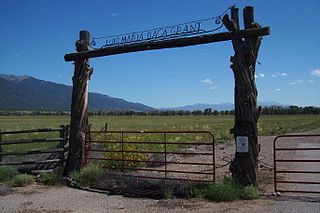
The Luis Maria Baca Grant No. 4, south of Crestone, Colorado, was a large land grant made in 1860 by the United States to the heirs of the original Vegas Grandes Grant at Las Vegas, New Mexico. Title to the grant at Las Vegas was clouded by a second grant of the same land. The Baca heirs were offered alternative lands from the public lands of the United States. The largest of the tracts selected, near what is now Crestone, was 12.5 miles (20.1 km) on a side and was located to the south of what is now Saguache County Road T, about 1-mile (1.6 km) south of the 38th parallel. The Bacas deeded the land to their attorney, but it soon passed by tax sale to a third party. The ranch headquarters was on Crestone Creek to the southwest of Crestone. The Baca Grant was one of the first large tracts of land to be fenced in the West and in its heyday was the home of prize Hereford cattle.

The Sangre de Cristo Wilderness is a long and narrow wilderness area covering 220,803 acres (893.56 km2) of the Sangre de Cristo Range centered about Saguache and Custer counties, Colorado. Smaller areas are located in Fremont, Alamosa, and Huerfano counties. All of the wilderness area is located on U.S. Forest Service land within the San Isabel and Rio Grande National Forests and Great Sand Dunes National Park and Preserve. The wilderness area is home to several fourteeners and quite a few thirteeners. Crestone Needle is considered the most difficult.

Tijeras Peak is a high mountain summit in the Sangre de Cristo Range of the Rocky Mountains of North America. The 13,610-foot (4,148 m) thirteener is located 9.8 miles (15.8 km) southeast by east of the Town of Crestone in Saguache County, Colorado, United States, in the Sangre de Cristo Wilderness on the boundary between Great Sand Dunes National Preserve and Rio Grande National Forest. Tijeras Peak is the highest summit in Great Sand Dunes National Park and Preserve. Tijeras is Spanish for scissors, and refers to the double-pronged rocky tip of the mountain.

State Highway 150 (SH 150) is a 16.114 mi-long (25.933 km) long state highway in southern Colorado. SH 150's southern terminus is at U.S. Route 160 (US 160) west of Blanca, and the northern terminus is at Great Sand Dunes National Park.

Zapata Falls is a waterfall located in the San Luis Valley near the base of the Sangre de Cristo Mountains on Bureau of Land Management land adjacent to Rio Grande National Forest and south of Great Sand Dunes National Park and Preserve in Alamosa County, Colorado. The waterfall has a drop of about 30 feet (9 m). Access to this waterfall entails a mildly steep 0.5-mile (800 m) hike. Viewing the falls requires fording the stream and climbing rocks.
Witchi-Tai-To is an album by the Jan Garbarek-Bobo Stenson Quartet released on the ECM label and performed by Garbarek, Stenson, Palle Danielsson, and Jon Christensen.

Mount Herard is a high and prominent mountain summit in the Sangre de Cristo Range of the Rocky Mountains of North America. The 13,345-foot (4,068 m) thirteener is located in the Sangre de Cristo Wilderness of Great Sand Dunes National Preserve, 15.0 miles (24.1 km) southeast of the Town of Crestone in Saguache County, Colorado, United States.
Mount Zwischen is a prominent mountain summit in the Sangre de Cristo Range of the Rocky Mountains of North America. The 12,011-foot (3,661 m) peak is located 32.1 miles (51.6 km) northeast of the City of Alamosa, Colorado, United States, on the drainage divide separating the Great Sand Dunes Wilderness in Great Sand Dunes National Preserve and Huerfano County from the Sangre de Cristo Wilderness in San Isabel National Forest and Saguache County.

Mosca Pass, elevation 9,714 feet, is a mountain pass in Alamosa and Huerfano counties in the Sangre de Cristo Range in southern Colorado. The pass lies on the eastern border of the Great Sand Dunes National Park and Preserve about 40 miles west of Walsenburg, Colorado. It marks the boundary between the Great Sand Dunes National Preserve to the west and San Isabel National Forest to the east, and it also lies on the border between Alamosa and Huerfano counties.
