
Snowdonia or Eryri, is a mountainous region in northwestern Wales and a national park of 823 square miles (2,130 km2) in area. It was the first to be designated of the three national parks in Wales, in 1951.

The Ffestiniog Railway is a heritage railway based on 1 ft 11+1⁄2 in narrow-gauge, located in Gwynedd, Wales. It is a major tourist attraction located mainly within the Snowdonia National Park.

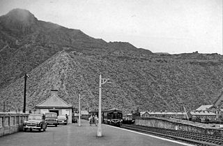
Blaenau Ffestiniog is a town in Gwynedd, Wales. Once a slate mining centre in historic Merionethshire, it now relies much on tourists, drawn for instance to the Ffestiniog Railway and Llechwedd Slate Caverns. It reached a population of 12,000 at the peak development of the slate industry, but fell with the decline in demand for slate. The population of the community, including the nearby village Llan Ffestiniog, was 4,875 in the 2011 census: the fourth most populous in Gwynedd after Bangor, Caernarfon and Llandeiniolen. The population not including Llan is now only about 4,000.
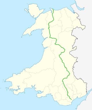
The A470 is a trunk road in Wales. It is the country's longest road at 186 miles (299 km) and links the capital Cardiff on the south coast to Llandudno on the north coast. While previously one had to navigate the narrow roads of Llanidloes and Dolgellau, both these market towns are now bypassed due to extensive road modernisation. The 26 miles (42 km) from Cardiff Bay to Merthyr Tydfil are mainly dual carriageway, but most of the route from north of Merthyr to Llandudno is single carriageway.

Dolwyddelan – in Victorian times, often spelled Dolyddelen – is a village and community in Conwy county borough, Wales, on the main A470 road between Blaenau Ffestiniog and Betws-y-Coed. As a community, the population of Dolwyddelan was recorded in the 2001 Census as 427, and 55.8% of those residents could speak Welsh. The population increased to 474 in the 2011 census with the proportion of Welsh speakers falling to 50.8%.
The Conwy Valley line is a railway line in north-west Wales. It runs from Llandudno via Llandudno Junction to Blaenau Ffestiniog, and was originally part of the London and North Western Railway, being opened in stages to 1879. The primary purpose of the line was to carry slate from the Ffestiniog quarries to a specially built quay at Deganwy for export by sea. The line also provided goods facilities for the market town of Llanrwst, and via the extensive facilities at Betws-y-Coed on the London to Holyhead A5 turnpike road it served many isolated communities in Snowdonia and also the developing tourist industry. Although only a little over 27 miles (43 km) between Llandudno and Blaenau Ffestiniog, the journey takes over one hour, largely due to the sinuous and steeply graded nature of the route taken. Most of the stations along the line are treated as request stops.

Foel-fras (944 m) is a mountain in the Carneddau range, about 10 km east of Bethesda in Wales. It lies on the border between the counties of Gwynedd and Conwy. With a summit elevation of 944 m it is officially the eleventh-highest summit in Wales. Foel-fras is located at the northern end of the main ridge of the Carneddau, between Drum to the north and Foel Grach to the south, with the subsidiary summit of Garnedd Uchaf (925 m) between it and Foel Grach. Due south and 400 m below lies the reservoir of Llyn Dulyn, while the smaller reservoir of Llyn Anafon lies to the north.

Roman Bridge railway station is a request stop passenger station in the Lledr Valley, Wales, on the Conwy Valley Line from Llandudno Junction to Blaenau Ffestiniog, which is operated by Transport for Wales Rail.

Pont-y-Pant railway station is a single platform passenger station in the Lledr Valley, Wales, on the Conwy Valley line from Llandudno Junction to Blaenau Ffestiniog, which is operated by Transport for Wales Rail. The station house is well maintained and used as a private dwelling.

Maentwrog is a village and community in the Welsh county of Merionethshire, lying in the Vale of Ffestiniog just below Blaenau Ffestiniog, within the Snowdonia National Park. The River Dwyryd runs alongside the village. Its population of 585 in 2001 increased to 631 at the 2011 Census. The Community of Maentwrog includes the village of Gellilydan.
Arenig railway station stood beneath Arenig Fawr on the Great Western Railway's Bala Ffestiniog Line in Gwynedd, Wales. It served this thinly populated upland area, but its particular purposes were to serve Arenig Granite quarry which opened in 1908 next to the station and to act as a passing loop on the largely single-track route. The railway was the quarry's main carrier and also its main customer, crushed stone being used for track ballast.

The Rhiwbach Tramway was a Welsh industrial, 1 ft 11+1⁄2 in narrow gauge railway connecting the remote slate quarries east of Blaenau Ffestiniog with the Ffestiniog Railway. It was in use by 1862, and remained so until progressively closed between 1956 and 1976. The route included three inclines, one of which became the last operational gravity incline in the North Wales slate industry. The tramway was worked by horses and gravity for much of its existence, but a diesel locomotive was used to haul wagons on the top section between 1953 and its closure in 1961.

The Lledr Valley is a valley in Snowdonia in north Wales. It runs from the top of the Crimea Pass, north of Blaenau Ffestiniog down to Betws-y-Coed.

The Blaen y Cwm quarry was a slate quarry located east of Blaenau Ffestiniog in Wales. It was first worked in some time between 1813 and 1818 and sporadically after that until 1914. The quarry was connected to the Ffestiniog Railway at Duffws Station via the Rhiwbach Tramway.

Graig Ddu quarry is a disused slate quarry near Blaenau Ffestiniog, in Gwynedd, North Wales. Although output was only about 3,000 tons a year, it reputedly has 36 saw tables and the same number of dressing machines on site. As with others in the area, the quarry suffered from a lack of water, resulting in the siting of the mill some distance away, at a lower level.
Cwm Prysor Halt was a railway station which served the remote rural area of Cwm Prysor, east of Trawsfynydd, Gwynedd, Wales.
Blaenau Ffestiniog North was the London and North Western Railway's (LNWR's) second passenger station in Blaenau Ffestiniog, then in Merionethshire, now in Gwynedd, Wales.

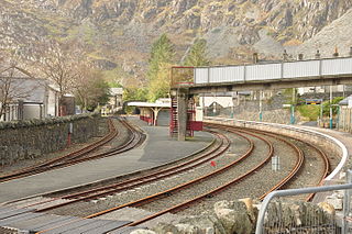
On 10 September 1883 the Bala and Festiniog Railway (B&FR) and the Festiniog Railway (FR) opened what would be known as an interchange station in Blaenau Ffestiniog, Merionethshire, Wales. Merionethshire is now part of the county of Gwynedd.

Owen Gethin Jones, was a Welsh building contractor, quarry owner and prominent poet.

Bwlch y Slaters quarry is a slate quarry near Blaenau Ffestiniog, in Gwynedd, North Wales.
