Cristianitos Creek

Last updated
Cristianitos Creek [1]
SanMateoCreekArroyoSanOnofre.jpg
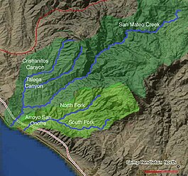
Map of San Mateo Creek and Arroyo San Onofre drainage basins. San Mateo Creek basin is in dark green.
Location
CountryUnited States
State California
Region Orange County, San Diego County
Physical characteristics
Sourceat the head of Cristianitos Canyon, Santa Ana Mountains, in Orange County County
  coordinates 33°30′36″N117°33′3″W / 33.51000°N 117.55083°W / 33.51000; -117.55083
  elevation800 ft (240 m)
Mouth confluence with San Mateo Creek, in San Diego County
  coordinates
33°25′11″N117°34′13″W / 33.41972°N 117.57028°W / 33.41972; -117.57028 Coordinates: 33°25′11″N117°34′13″W / 33.41972°N 117.57028°W / 33.41972; -117.57028
  elevation
75 ft (23 m)
Length7 mi (11 km)
Discharge 
  location Pacific Ocean
Basin features
Tributaries 
  left Gabino Canyon Creek, Talega Canyon Creek

Cristianitos Canyon Creek, a stream or arroyo, tributary to San Mateo Creek, in the Santa Ana Mountains. its source is within Orange County, California. Its source is at an altitude of 800 feet, at the head of Cristianitos Canyon, in the foothills of the Santa Ana Mountains, in Orange County. [2] It flows southwestward down Cristianitos Canyon, then turns south towards its confluence with San Mateo Creek, at an elevation of 75 feet, in San Diego County. [3]

Along its course it has two major tributaries that come in from the left bank from the Santa Ana Mountains southwest and south of the Verdugo Potrero. First Gabino Canyon Creek, 7 miles long, that arises at an elevation of 1840 feet in the Santa Ana Mountains, in the extreme southwestern part of Riverside County, a mile north of the San Diego County line and flows southwest, adding the waters of La Paz Canyon Creek on its way to its confluence with Cristianitos Creek, at the mouth of Cristianitos Cahyon, at an elevation of 301 feet in Orange County. [4] Second is Talega Canyon Creek, 10 miles long, that also arises in the Santa Anna Mountains, in southwestern part of Riverside County at altitude 2000 feet above sea level. It flows southwestward into Orange County until it reaches its confluence with Cristianitos Creek at an elevation of 177 ft feet just over the county line in San Diego County, on the Marine Corps Base Camp Pendleton. [5] [6]

Related Research Articles

<span class="mw-page-title-main">San Jacinto River (California)</span> River in California, United States

The San Jacinto River is a 42-mile-long (68 km) river in Riverside County, California. The river's headwaters are in Santa Rosa and San Jacinto Mountains National Monument. The lower portion of the 765-square-mile (1,980 km2) watershed is urban and agricultural land. As a partially endorheic watershed that is contiguous with other Great Basin watersheds, the western side of the San Jacinto Basin is a portion of the Great Basin Divide.

<span class="mw-page-title-main">Lytle Creek (California)</span> River in the United States

Lytle Creek, California, is an approximately 18-mile-long (29 km) stream in southwestern San Bernardino County near the city of San Bernardino. It is a tributary of Warm Creek, a tributary of the Santa Ana River. The Mormon settlers of San Bernardino named the stream "Lytle Creek" after their leader, Captain Andrew Lytle. The Tongva village of Wa’aachnga was located along Lytle Creek.

<span class="mw-page-title-main">San Juan Creek</span> River in Orange County, California, United States

San Juan Creek, also called the San Juan River, is a 29-mile (47 km) long stream in Orange and Riverside Counties, draining a watershed of 133.9 square miles (347 km2). Its mainstem begins in the southern Santa Ana Mountains in the Cleveland National Forest. It winds west and south through San Juan Canyon, and is joined by Arroyo Trabuco as it passes through San Juan Capistrano. It flows into the Pacific Ocean at Doheny State Beach. San Juan Canyon provides a major part of the route for California State Route 74.

<span class="mw-page-title-main">San Diego Creek</span> River in California, United States

San Diego Creek is a 16-mile (26 km) urban waterway flowing into Upper Newport Bay in Orange County, California in the United States. Its watershed covers 112.2 square miles (291 km2) in parts of eight cities, including Irvine, Tustin, and Costa Mesa. From its headwaters in Laguna Woods the creek flows northwest to its confluence with Peters Canyon Wash, where it turns abruptly southwest towards the bay. Most of the creek has been converted to a concrete flood control channel, but it also provides important aquatic and riparian habitat along its course and its tidal estuary.

<span class="mw-page-title-main">Coyote Creek (San Gabriel River tributary)</span> Tributary of the San Gabriel River in California

Coyote Creek is a principal tributary of the San Gabriel River in northwest Orange County, southeast Los Angeles County, and southwest Riverside County, California. It drains a land area of roughly 41.3 square miles (107 km2) covering eight major cities, including Brea, Buena Park, Fullerton, Hawaiian Gardens, La Habra, Lakewood, La Palma, and Long Beach. Some major tributaries of the creek in the highly urbanized watershed include Brea Creek, Fullerton Creek, and Carbon Creek. The mostly flat creek basin is separated by a series of low mountains, and is bounded by several small mountain ranges, including the Chino Hills, Puente Hills, and West Coyote Hills.

<span class="mw-page-title-main">Peters Canyon Wash</span>

Peters Canyon Wash is a tributary of San Diego Creek in central Orange County in the U.S. state of California. About 11.8 miles (19.0 km) long north-south, the wash, now mostly channelized, flows in a relatively straight course southwest from the 55-acre (0.22 km2) Peters Canyon Reservoir near the Orange/Tustin borderline to its confluence with San Diego Creek near the Irvine Civic Center Plaza. Less than 5 miles (8.0 km) below this confluence, San Diego Creek empties into Upper Newport Bay. The largest tributary of Peters Canyon is the Santa Ana Channel

<span class="mw-page-title-main">San Mateo Creek (Southern California)</span> River in California, United States

San Mateo Creek is a stream in Southern California in the United States, whose watershed mostly straddles the border of Orange and San Diego Counties. It is about 22 miles (35 km) long, flowing in a generally southwesterly direction. Draining a broad valley bounded by the Santa Ana Mountains and Santa Margarita Mountains, San Mateo Creek is notable for being one of the last unchannelized streams in Southern California.

Serrano Creek is a roughly 7.5-mile (12.1 km) tributary of San Diego Creek in the U.S. state of California. The creek starts in the Santa Ana Mountains in a canyon in Whiting Ranch Wilderness Park, near the boundary of the Cleveland National Forest. It then flows southwest into the city of Lake Forest, running in a channelized course roughly parallel to Aliso Creek. It abruptly turns northwest then southwest at 90-degree angles as it enters a large storm drain that takes it the rest of the way to the confluence with the La Cañada Channel, creating the main stem of San Diego Creek.

<span class="mw-page-title-main">Temescal Creek (Riverside County)</span> River in the United States

Temescal Creek is an approximately 29-mile-long (47 km) watercourse in Riverside County, in the U.S. state of California. Flowing primarily in a northwestern direction, it connects Lake Elsinore with the Santa Ana River. It drains the eastern slopes of the Santa Ana Mountains on its left and on its right the western slopes of the Temescal Mountains along its length. With a drainage basin of about 1,000 square miles (2,600 km2), it is the largest tributary of the Santa Ana River, hydrologically connecting the 720-square-mile (1,900 km2) San Jacinto River and Lake Elsinore watersheds to the rest of the Santa Ana watershed. However, flowing through an arid rain shadow zone of the Santa Ana Mountains, and with diversion of ground water for human use, the creek today is ephemeral for most of its length, except for runoff from housing developments and agricultural return flows.

Spencer Valley, originally known as Coleman Valley in the 19th century, is a mountain valley located in San Diego County, California, at an elevation of 3605 ft. It lies east of the Santa Ysabel Valley and northwest of the town of Julian in the Cuyamaca Mountains. It is drained by Baily Creek which runs down the valley from the north to its confluence with Coleman Creek in the south end of the valley. Its tributary from the east, Jim Green Creek meets Baily Creek just before its confluence with Coleman Creek, that runs from east to west down from Julian to the headwaters of the San Diego River. The unincorporated community of Wynola lies along State Highway 78, in the middle of the valley.

Coleman Creek in San Diego County, California is a tributary of the San Diego River that arises at the top of the valley running southeasterly from Julian, at a saddle between two ridges of the Cuyamaca Mountains just south of Kentwood-In-The-Pines. From there, Coleman Creek descends northwesterly down the valley to Julian, where it turns west, descending its canyon northwesterly through the site of Branson City, past the mouth of its tributary Eastwood Creek on the north, passing through the south end of Spencer Valley, past the mouth of its tributary Baily Creek on the north, then descending northwest down Quanai Canyon to its confluence with the San Diego River.

Eastwood Creek in San Diego County, California, is a tributary of Coleman Creek that arises in the Cuyamaca Mountains, at the north face of the gold bearing mountain north of Julian. From the source Eastwood Creek descends northwesterly a short distance, then turns southwest down a canyon to its confluence with Coleman Creek, just below the site of Branson City.

<span class="mw-page-title-main">San Mateo Peak</span>

San Mateo Peak is the unofficially named 3,591-foot (1,095 m) peak, at the western end of the ridge running west then northwest from Elsinore Peak to Morrell Canyon, south and west of the Morrell Potrero in the Elsinore Mountains of the Santa Ana Mountain Range. The peak name was given by Sierra Club Lower Peaks Committee Guide, originally named by Ken Croker who for 20 years maintained trails in the Santa Ana Mountains with volunteers from the Sierra Club. It remains officially nameless despite being the highest summit in the Elsinore Mountains, higher than Elsinore Peak, at 3536 ft., the highest named peak in those mountains.

Carbondale, in Orange County, California, is a historical coal mining town in Santiago Canyon, where Santiago Creek had its confluence with Silverado Creek in Silverado, California. It had a post office from May 11, 1881, to January 29, 1884, when it was closed and mail sent to the Santa Ana post office.

<span class="mw-page-title-main">Elsinore Mountains</span>

The Elsinore Mountains are a ridge of mountains within the larger range of the Santa Ana Mountains, in the Cleveland National Forest, Riverside County, California, United States. the tallest peaks within the range is the unofficially named San Mateo Peak at 3,591 ft (1,095 m). Second is officially named Elsinore Peak at 3,536 ft (1,078 m). The Elsinore Mountanins run in a ridge from just east of El Cariso, southeast to Elsinore Peak. Beyond that peak the ridge begins to descend and curves to the east. From Elsinore Peak, a ridge runs to the west and then northwest to San Mateo Peak, enclosing the Morrell Potrero on the south and west.

<span class="mw-page-title-main">Morrell Canyon Creek</span> River in California, United States

Morrell Canyon Creek is a stream or Arroyo, tributary to San Juan Creek, located in the Cleveland National Forest in Riverside County, California, at an elevation of 3,080 ft (939 m), in the Elsinore Mountains northeast of Elsinore Peak. It arises on the eastern slope of San Mateo Peak. An eastern fork draining the Morrell Potrero joins it a little over a mile north of its source and then flows northwestward about a third of a mile where it turns southeast descending the narrow Morrell Canyon east of Lion Spring. After descending 2.5 miles it turns north for half a mile then returns to a southwestern direction for another mile, the canyon widening here until it turns northwestward and down a steep canyon again for half a mile where it takes in from the right Decker Canyon Creek and Long Canyon Creek. It then turns southwestward again into a wider canyon and descends to its confluence with Bear Canyon Creek and becomes the head of San Juan Creek.

<span class="mw-page-title-main">Los Alamos Canyon Creek</span> River in California, United States

Los Alamos Canyon Creek, a stream or arroyo, tributary to San Mateo Creek, in the Cleveland National Forest in Riverside County, California. Its source is at an altitude of 2300 feet, in a canyon on the south face of the ridge of Elsinore Mountains that descends to the southeast from Elsinore Peak. The creek descends southward for a short distance then turns southwest for 4 miles where it turns west for 3 miles down Los Alamos Canyon to its confluence with San Mateo Creek at an elevation of 1312 feet.

<span class="mw-page-title-main">Tenaja Canyon Creek</span> River in California, United States

Tenaja Canyon Creek, a stream or arroyo, tributary to San Mateo Creek, in the Cleveland National Forest in Riverside County, California. Its source is at an altitude of 1875 feet. The creek has its source at the confluence of arroyos from El Potrero del Tenaja, Redonda Mesa and Tenaja Mountain highlands. and it flows northwestward 3+12 miles down Tenaja Canyon to its mouth and its confluence near Fishermans Camp, at an elevation of 1112 feet with San Mateo Creek. The word may refer to the arroyo El Portero del Tenaja or to the topographic structure.

<span class="mw-page-title-main">Devil Canyon Creek</span> River in California, United States

Devil Canyon Creek, a stream or arroyo, tributary to San Mateo Creek, in the Santa Margarita Mountains, all but its first and last part within the Cleveland National Forest in San Diego County, California. Its source is at an altitude of 2440 feet on a flat private land in the Santa Margarita Mountains. and it flows southwestward then turns down into the canyon and the San Mateo Wilderness and northward 2 miles before turning westward toward its confluence in San Mateo Canyon with San Mateo Creek at an elevation of 453 feet. The last half mile of the creek before this confluence is outside the National Forest boundary, and within the Camp Pendleton Marine Corps Base. Devil Canyon has one named tributary, Cold Spring Canyon Creek, draining the Santa Margarita Mountains north of the Devil Canyon watershed that enters it from the right about a mile and half above the confluence of Devil Canyon Creek with San Mateo Creek.

Temescal Mountains, also known as the Sierra Temescal, are one of the northernmost mountain ranges of the Peninsular Ranges in western Riverside County, in Southern California in the United States. They extend for approximately 25 mi (40 km) southeast of the Santa Ana River east of the Elsinore Fault Zone to the Temecula Basin and form the western edge of the Perris Block.

References