Related Research Articles
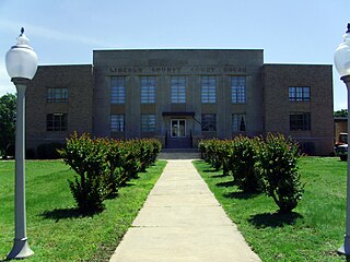
Lincoln County is located between the Arkansas Timberlands and Arkansas Delta in the U.S. state of Arkansas. It is also within the Pine Bluff metro area, and on the outer edge of the Central Arkansas region. The county is named for President Abraham Lincoln. Created as Arkansas's 65th county on March 28, 1871, Lincoln County has three incorporated cities, including Star City, the county seat and most populous city. The county contains 46 unincorporated communities and ghost towns, Cane Creek State Park at the confluence of Cane Creek and Bayou Bartholomew, and nine listings on the National Register of Historic Places to preserve the history and culture of the county.

Arkansas County is a county located in the U.S. state of Arkansas. As of the 2020 census, the population was 17,149. Located in the Arkansas Delta, the county has two county seats, DeWitt and Stuttgart.
St. Francis is a city in northeastern Clay County, Arkansas, United States, along the St. Francis River. The population was 250 at the 2010 census.

For people with the surname, see Redfield (surname).

Sherrill is a town in Plum Bayou Township, Jefferson County, Arkansas, United States. Its population was 84 at the 2010 U.S. census. It is included in the Pine Bluff, Arkansas Metropolitan Statistical Area.

Wabbaseka is a town in Dunnington Township, Jefferson County, Arkansas, United States. Its population was 255 at the 2010 U.S. census. It is included in the Pine Bluff, Arkansas Metropolitan Statistical Area.

DeValls Bluff is a city in and the county seat of the southern district of Prairie County, Arkansas, United States. The population was 619 at the 2010 census.
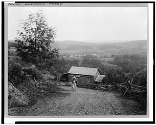
Dingmans Ferry is an unincorporated community in Delaware Township, Pike County, Pennsylvania, United States. As of 2014, it had a population of just over 1,000 people. It was originally sited on the Delaware River, in an area now included in the Delaware Water Gap National Recreation Area. When the Corps of Engineers acquired the land by eminent domain in the mid-twentieth century for the creation of the proposed Tocks Island Dam project, it relocated the community further up the hill.
DeWitt School District No. 1 is a school district based in the town of DeWitt, Arkansas, United States. The DeWitt School District is geographically the state's largest school district with 872.29 square miles (2,259.2 km2) of land and 46.18 square miles (119.6 km2) of water, encompassing portions of Arkansas and Jefferson, and Desha counties.
Solgohachiasaw-gə-HA-chee is an unincorporated community in Conway County, Arkansas, United States, about 10 miles (16 km) north of Morrilton on Arkansas Highway 9 and Arkansas Highway 287. The ZIP Code for Solgohachia is 72156. The name is from the Choctaw word Sok-ko-huch-cha, meaning "muscadine river".
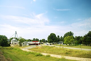
Tichnor is an unincorporated community in Arkansas County, Arkansas, United States. It is the location of the Tichnor Rice Dryer and Storage Building, and is the nearest community to the Roland Site, both listed on the National Register of Historic Places. The ZIP Code for Tichnor is 72166.
Hiwasse was an unincorporated census-designated place in Benton County, Arkansas, United States. As of the 2010 census, its population was 497. It is the location of Hiwasse Bank Building, which is located at Main St., AR 279 and Banks House, which is located on AR 72 west of Hiwasse. Both are listed on the National Register of Historic Places.
Lake Dick is an unincorporated community in Jefferson County, Arkansas, United States. Lake Dick is northeast of Pine Bluff and south of Altheimer.
Drasco is an unincorporated community and census-designated place (CDP) in Cleburne County, Arkansas, United States, with a ZIP code of 72530. Drasco lies just northeast of Greers Ferry Lake and includes the lakeside community of Tannenbaum.

Moscow is an unincorporated community in Jefferson County, Arkansas, United States. Moscow is located near the junction of U.S. Route 65 and Arkansas Highway 199, 13 miles (21 km) east-southeast of Pine Bluff. Moscow has a post office with ZIP code 71659.
Reydell or Reydel is an unincorporated community in Jefferson County, Arkansas, United States. Reydell is located at the junction of Arkansas Highway 11 and Arkansas Highway 88, 16 miles (26 km) southwest of De Witt. Reydell has a post office with ZIP code 72133.
Wright is an unincorporated community in Jefferson County, Arkansas, United States. Wright is located on Arkansas Highway 256, 7.5 miles (12.1 km) west-northwest of Sherrill. Wright has a post office with ZIP code 72182.
Ethel is an unincorporated community in Arkansas County, Arkansas, United States. Ethel is located on Arkansas Highway 17, 10 miles (16 km) east of DeWitt. Ethel has a post office with ZIP code 72048.
DeWitt High School is a comprehensive public high school located in DeWitt, Arkansas, United States. The school provides secondary education for students in grades 9 through 12. DeWitt is one of two public high schools in Arkansas County, Arkansas and the sole high school administered by the DeWitt School District.
Pastoria, also known as Pastoria Township, in an unincorporated community in Jefferson County, Arkansas. It lost population to Sherrill, Arkansas after a rail line bypassed it in the 19th century.
References
- 1 2 U.S. Geological Survey Geographic Names Information System: Crocketts Bluff, Arkansas
- ↑ "National Register Information System". National Register of Historic Places . National Park Service. March 13, 2009.
- ↑ "Crocketts Bluff ZIP Code". zipdatamaps.com. 2022. Retrieved November 11, 2022.
- ↑ "SCHOOL DISTRICT REFERENCE MAP (2010 CENSUS): Arkansas County, AR." U.S. Census Bureau. Retrieved on May 24, 2018.
- ↑ "General Highway Map Arkansas County, Arkansas" (PDF). Arkansas Department of Transportation. Archived from the original (PDF) on October 2, 2018. Retrieved February 25, 2021. - See Crocketts Bluff on the map.
Municipalities and communities of Arkansas County, Arkansas, United States | ||
|---|---|---|
| Cities |  | |
| Towns | ||
| Other communities | ||
| Footnotes | ‡This populated place also has portions in an adjacent county or counties | |
34°26′38″N91°13′12″W / 34.44389°N 91.22000°W
| | This article about a location in Arkansas County, Arkansas is a stub. You can help Wikipedia by expanding it. |