
Wallsend, historically Wallsend on Tyne, is a town in the metropolitan borough of North Tyneside, North East of England, in the traditional county of Northumberland. Wallsend derives its name as the location of the end of Hadrian's Wall. It has a population of 42,842 and lies 3.5 miles east of Newcastle City Centre. The population of the Wallsend ward of the North Tyneside Borough was at the 2011 census 10,304.
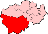
Teesdale was, from 1974 to 2009, a local government district in County Durham, England. Its council was based in Barnard Castle and it was named after the valley of the River Tees.

Wear Valley was, from 1974 to 2009, a local government district in County Durham, England. Its council and district capital was Crook.

Meadowfield is a small village in County Durham, England, situated approximately 2 miles south-west of Durham on the A690. It is situated within the civil parish of Brandon and Byshottles.
Page Bank is a village in County Durham, in England. It is situated on the north bank of the River Wear to the east of Willington and to the north-west of Spennymoor.
Morton Tinmouth is a village or, perhaps more accurately, a hamlet of a few farms in County Durham, England. It is situated a few miles to the north-west of Darlington close to the village of Bolam.

Helmington Row is a small village in County Durham, in the North East of England and is part of the parish of Crook, County Durham. It is situated between Crook and Willington. About 7 miles South West of Durham and 3 miles North, North West of Bishop Auckland.
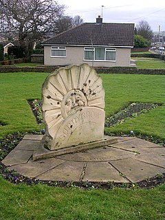
Sunnybrow is a village in County Durham, in England. In the 2001 census Sunnybrow had a population of 1,296. It is effectively the southern suburb of Willington.

Oakenshaw is a village in County Durham, in England. It is situated to the north of Willington. In the 2001 census Oakenshaw had a population of 470.
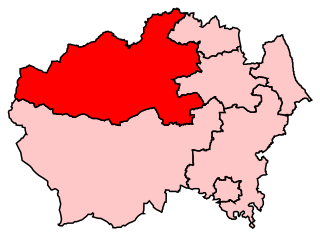
Penrith and the Border is a constituency in Cumbria represented in the House of Commons of the UK Parliament since 2010 by Rory Stewart, a Conservative.
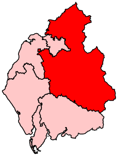
North West Durham is a constituency represented in the House of Commons of the UK Parliament since 8 June 2017 by Laura Pidcock of the Labour Party.
Saltburn, Marske and New Marske is a civil parish in Redcar and Cleveland in north east England. According to the 2001 census it had a population of 18,325 increasing to 19,134 at the 2011 census. The parish includes Saltburn-by-the-Sea, Marske-by-the-Sea and the inland settlement of New Marske. It borders the parishes of Skelton and Brotton, Guisborough and the unparished area of Redcar.
Central Lancashire is an area of Lancashire, England.

Crook Town Association Football Club is a football club based in Crook, County Durham, England. They are currently members of the Northern League Division Two and play at the Sir Tom Cowie Millfield. The club won the FA Amateur Cup five times.

Willington Association Football Club is an English football club based in Willington, County Durham. The club are currently members of the Northern League Division Two and play at Hall Lane.

Darlington is a unitary authority area in the ceremonial county of County Durham, north-east England. It borders the non-metropolitan county of County Durham to the north and west, Stockton-on-Tees to the east and North Yorkshire to the south along the line of the River Tees. The urban centre and the base of the borough is the town of Darlington. In 2011 it had a resident population of 106,000. The borough is a member of the Tees Valley combined authority area.
Willington Quay is an area in the borough of North Tyneside in Tyne and Wear in northern England. It is situated on the north bank of the River Tyne, facing Jarrow, and between Wallsend and North Shields. It is served by the Howdon Metro station in Howdon. The area from 2006 onwards has been an area of new housing built on brownfield sites. The house building continues into 2013 and is changing the social and economic balance in the area. The area has also had a make over of the bowling green off Howdon Lane and further warehousing next to the bowling green has been demolished to make way for further new housing. The changes made recently at Willington Quay are now making it an attractive place to live within North Tyneside.
Tynemouth was a rural district in the English county of Northumberland.
National Cycle Network (NCN) Route 70 is a Sustrans National Route that runs from Walney Island in Cumbria to Sunderland. The route is fully open and signed. From end to end the route is 149 miles (240 km), but two sections are shared with other NCN routes leaving Route 70 at 128 miles (206 km).

