Crowheart Butte

Last updated
Crowheart Butte
Crowheart Butte in Wyoming.jpg
Crowheart Butte from the southeast, 2022
Highest point
Elevation 2,064 m (6,772 ft) [1]
Prominence 210 m (690 ft)
Coordinates 43°18′37″N109°05′41″W / 43.31023°N 109.09485°W / 43.31023; -109.09485 Coordinates: 43°18′37″N109°05′41″W / 43.31023°N 109.09485°W / 43.31023; -109.09485
Geography
USA Wyoming location map.svg
Red triangle with thick white border.svg
Crowheart Butte
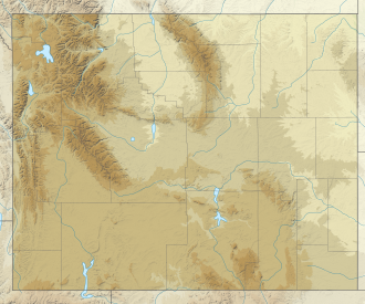
Location of Crowheart Butte in Wyoming

Crowheart Butte is a summit located in the Wind River Valley in rural Fremont County, Wyoming. [1] The community of Crowheart is located nearby.

Crowheart Butte was named after an 1866 battle between the Shoshone Crow tribes. According to legend, following a five-day battle for hunting rights in the Wind River Range, Chief Washakie of the Shoshone and Chief Big Robber of the Crow agreed to a duel to decide the winner. Chief Washakie slew his opponent, but impressed with his courage, cut out his heart and placed it on the end of his lance. [2]
Related Research Articles

Fremont County, Wyoming County in Wyoming, United States

Fremont County is a county in the U.S. state of Wyoming. As of the 2020 United States Census, the population was 39,234, making it the fifth-most populous county in Wyoming. Its county seat is Lander. The county was founded in 1884 and is named for John C. Frémont, a general, explorer, and politician. It is roughly the size of the state of Vermont.

Crowheart, Wyoming CDP in Wyoming, United States

Crowheart is a census-designated place (CDP) in Fremont County, Wyoming, United States. The population was 141 at the 2010 census. Nearby Crowheart Butte was the site of a battle between the Crow and Shoshone American Indian tribes in 1866. According to legend, following a five-day battle for rights to the hunting grounds in the Wind River Range, Chief Washakie of the Shoshone and Chief Big Robber of the Crow agreed to a duel, with the winner gaining the rights to the Wind River hunting grounds. Chief Washakie eventually prevailed, but he was so impressed with the courage of his opponent, that rather than scalp him, he instead cut out his heart and placed it on the end of his lance.

Fort Washakie, Wyoming CDP in Wyoming, United States

Fort Washakie is a census-designated place (CDP) in Fremont County, Wyoming, United States, within the Wind River Indian Reservation and along U.S. Route 287. The population was 1,759 at the 2010 census. The headquarters for the Eastern Shoshone Tribe is located in Fort Washakie, as well as the Bureau of Indian Affairs agency for the Wind River Indian Reservation.

Lander, Wyoming City in Wyoming, United States

Lander is a city in Wyoming, United States, and the county seat of Fremont County. It is in central Wyoming, along the Middle Fork of the Popo Agie River, just south of the Wind River Indian Reservation. It is a tourism center with several nearby guest ranches. Its population was 7,487 at the 2010 census.

The Shoshone or Shoshoni are a Native American tribe with four large cultural/linguistic divisions:

Washakie Eastern Shoshone chief

Washakie was a prominent leader of the Shoshone people during the mid-19th century. He was first mentioned in 1840 in the written record of the American fur trapper, Osborne Russell. In 1851, at the urging of trapper Jim Bridger, Washakie led a band of Shoshones to the council meetings of the Treaty of Fort Laramie (1851). Essentially from that time until his death, he was considered the head of the Eastern Shoshones by the representatives of the United States government. In 1979, he was inducted into the Hall of Great Westerners of the National Cowboy & Western Heritage Museum.

Jim Baker (frontiersman)

Jim Baker (1818–1898), known as "Honest Jim Baker", was a frontiersman, trapper, hunter, army scout, interpreter, and rancher. He was first a trapper and hunter. The decline of the fur trade in the early 1840s drove many trappers to quit, but Baker remained in the business until 1855. During that time he was a friend of Jim Bridger, Kit Carson and John C. Frémont. On August 21, 1841, he was among a group of twenty three trappers who were attacked by Arapaho, Cheyenne, and Sioux on what became known as Battle Mountain. After Henry Fraeb was killed, Baker organized the trappers against the Native Americans in a multiple-day fight.

Wind River Indian Reservation Indian reservation in Wyoming, United States

The Wind River Indian Reservation, in the west-central portion of the U.S. state of Wyoming, is shared by two Native American tribes, the Eastern Shoshone and the Northern Arapaho. Roughly 60 mi (97 km) east to west by 50 mi (80 km) north to south, the Indian reservation is located in the Wind River Basin, and includes portions of the Wind River Range, Owl Creek Mountains, and Absaroka Range.

Shoshone National Forest National Forest in Wyoming, US

Shoshone National Forest is the first federally protected National Forest in the United States and covers nearly 2,500,000 acres (1,000,000 ha) in the state of Wyoming. Originally a part of the Yellowstone Timberland Reserve, the forest is managed by the United States Forest Service and was created by an act of Congress and signed into law by U.S. President Benjamin Harrison in 1891. Shoshone National Forest is one of the first nationally protected land areas anywhere. Native Americans have lived in the region for at least 10,000 years, and when the region was first explored by European adventurers, forestlands were occupied by several different tribes. Never heavily settled or exploited, the forest has retained most of its wildness. Shoshone National Forest is a part of the Greater Yellowstone Ecosystem, a nearly unbroken expanse of federally protected lands encompassing an estimated 20,000,000 acres (8,100,000 ha).

Fort Washakie United States historic place

Fort Washakie was a U.S. Army fort in what is now the U.S. state of Wyoming. The fort was established in 1869 and named Camp Augur after General Christopher C. Augur, commander of the Department of the Platte. In 1870 the camp was renamed Camp Brown in honor of Captain Frederick H. Brown, who was killed in the Fetterman Massacre in 1866.

James Trosper

James Trosper is an Arapahoe running the Eastern Shoshone Sun Dance chief and “a respected voice on traditional Plains Indian spirituality.” He is Director of the High Plains American Indian Research Institute. HPAIRI facilitates a wide variety of partnerships between the University of Wyoming and the tribes of the Wind River Indian Reservation in Fort Washakie, Wyoming “to work together in ways that empower tribes, nurture innovation for American Indian sustainability, and demonstrate respect for Native peoples’ cultures, traditions, laws, and diverse expressions of sovereignty.”

The Bates Battlefield was the scene of an 1874 action in which an Arapaho encampment was attacked by U.S. Army forces under Captain Alfred E. Bates. The battlefield is a narrow valley in Hot Springs County, Wyoming near the junction of the Big Horn Mountains and the Owl Creek Mountains. Variously called the Bates Battle, the Battle of Young's Point, the Battle of Snake Mountain and the Nowood Battle, the action was part of a campaign by forces under the command of Lieutenant General Philip Sheridan to protect the comparatively sedentary Shoshone under Chief Washakie from raids by their traditional enemies, the Northern Cheyenne, the Sioux and the Northern Arapaho.

Eastern Shoshone

Eastern Shoshone are Shoshone who primarily live in Wyoming and in the northeast corner of the Great Basin where Utah, Idaho and Wyoming meet and are in the Great Basin classification of Indigenous People. They lived in the Rocky Mountains during the 1805 Lewis and Clark Expedition and adopted Plains horse culture in contrast to Western Shoshone that maintained a Great Basin culture.

Shoshone-Episcopal Mission United States historic place

Shoshone-Episcopal Mission is a historic mission and school in Fort Washakie, Wyoming. The school was built from 1889 to 1890 by Rev. John Roberts, the minister and teacher on the Wind River Indian Reservation. Roberts built the boarding school to teach the Shoshone girls living on the reservation; as many of the students lived up to 20 miles (32 km) away from the school, it was necessary to build a boarding school to teach them. The school later became the headquarters of the entire Episcopal mission on the reservation.

Mount Washakie is located in the Wind River Range in the U.S. state of Wyoming. The mountain is on the Continental Divide in the Bridger Wilderness of Bridger-Teton National Forest and Popo Agie Wilderness of Shoshone National Forest. Washakie Glacier lies .50 mi (0.80 km) to the southeast of the peak.

St. Michaels Mission (Ethete, Wyoming) United States historic place

St. Michael's Mission is an Episcopal church mission established about 1887 in Fremont County, Wyoming to minister to the Arapaho and Shoshone of the Wind River Indian Reservation. It was founded by Reverend John Roberts with the permission of Shoshone Chief Washakie. The community of Ethete grew around the mission, given its name by Washakie's assent in the Shoshone language, ethete. In 1900 a small log church was built about 3 miles (4.8 km) from the present location. In 1910 the mission received an endowment from Mrs. Baird Cooper and the new site was developed over the next seven years. In 1920 the original church was moved to the mission, enlarged, and named "The Church of Our Father's House.

Statue of Washakie American sculpture series

The sculptor David McGary has created a standing statue of Chief Washakie, leader of the Shoshone people, in multiple versions, as well as an equestrian statue of the same subject.

Big Robber Crow tribe leader

Chief Big Robber, also known as Big Shadow or Big Robert, was a 19th century Crow chief. He was a participant in the Fort Laramie Treaty of 1851. His name Big Shadow referred to his large stature.

Black Bear was an Arapaho leader into the 1860s when the Northern Arapaho, like other Native American tribes, were prevented from ranging through their traditional hunting grounds due to settlement by European-Americans who came west during the Pike's Peak Gold Rush. Conflicts erupted over land and trails used by settlers and miners. A watershed event was the Sand Creek massacre of 1864. This led to the Northern Arapaho joining with other tribes to prevent settlement in their traditional lands. In 1865, Black Bear's village was attacked during the Battle of the Tongue River. People died, lodges were set on fire, and food was ruined, all of which made it difficult for them to survive as a unit. He died during an ambush by white settlers on April 8, 1870 in the Wild Wind Valley of present-day Wyoming.

Friday (Arapaho chief) Chief and interpreter of Northern Arapaho

Friday (Arapaho: Teenokuhu or Warshinun, also known as Friday Fitzpatrick, was an Arapaho leader and interpreter in the mid to late 1800s. When he was around the age of eight, he was separated from his band and was taken in by a white trapper. During the next seven years, he was schooled in St. Louis, Missouri and went on trapping expeditions with his informally adopted father, Thomas Fitzpatrick. After he was recognized by his mother during an encounter with the Arapaho, he returned to the tribe.

References

  1. 1 2 "GNIS Detail – Crowheart Butte". geonames.usgs.gov. Retrieved 12 September 2021.
  2. Dayton, Kelsey (2 March 2018). "The battle of Crowheart Butte". WyoFile.

Further reading