Mesa Verde National Park is an American national park and UNESCO World Heritage Site located in Montezuma County, Colorado, and the only World Heritage Site in Colorado. The park protects some of the best-preserved Ancestral Puebloan ancestral sites in the United States.
The Pecos Classification is a chronological division of all known Ancestral Puebloans into periods based on changes in architecture, art, pottery, and cultural remains. The original classification dates back to consensus reached at a 1927 archæological conference held in Pecos, New Mexico, which was organized by the United States archaeologist Alfred V. Kidder.

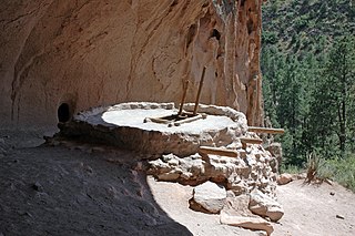
A kiva is a space used by Puebloans for rites and political meetings, many of them associated with the kachina belief system. Among the modern Hopi and most other Pueblo peoples, "kiva" means a large room that is circular and underground, and used for spiritual ceremonies.

Chaco Culture National Historical Park is a United States National Historical Park in the American Southwest hosting a concentration of pueblos. The park is located in northwestern New Mexico, between Albuquerque and Farmington, in a remote canyon cut by the Chaco Wash. Containing the most sweeping collection of ancient ruins north of Mexico, the park preserves one of the most important pre-Columbian cultural and historical areas in the United States.

Hovenweep National Monument is located on land in southwestern Colorado and southeastern Utah, between Cortez, Colorado and Blanding, Utah on the Cajon Mesa of the Great Sage Plain. Shallow tributaries run through the wide and deep canyons into the San Juan River.

Salmon Ruins is an ancient Chacoan and Pueblo site located in the northwest corner of New Mexico, USA. Salmon was constructed by migrants from Chaco Canyon around 1090 CE, with 275 to 300 original rooms spread across three stories, an elevated tower kiva in its central portion, and a great kiva in its plaza. Subsequent use by local Middle San Juan people resulted in extensive modifications to the original building, with the reuse of hundreds of rooms, division of many of the original large, Chacoan rooms into smaller rooms, and emplacement of more than 20 small kivas into pueblo rooms and plaza areas. The site was occupied by ancient Ancestral Puebloans until the 1280s, when much of the site was destroyed by fire and abandoned. The pueblo is situated on the north bank of the San Juan River, just to the west of the modern town of Bloomfield, New Mexico, and about 45 miles (72 km) north of Pueblo Bonito in Chaco Canyon. The site was built on the first alluvial terrace above the San Juan River floodplain.
Casa Chiquita is an Ancestral Puebloan great house and archaeological site located in Chaco Canyon, northwestern New Mexico, United States.

Chetro Ketl is an Ancestral Puebloan great house and archeological site located in Chaco Culture National Historical Park, New Mexico, United States. Construction on Chetro Ketl began c. 990 and was largely complete by 1075, with significant remodeling occurring in the early and mid-1110s. Following the onset of a severe drought, most Chacoans emigrated from the canyon by 1140; by 1250 Chetro Ketl's last inhabitants had vacated the structure.

The Canyons of the Ancients Visitor Center and Museum located in Dolores, Colorado, is an archaeological museum of Native American pueblo and hunter-gatherer cultures. Two 12th-century archaeological sites, the Escalante and Dominguez Pueblos, at the center were once home to Ancient Pueblo peoples. The museum's permanent and special exhibits display some of the 3 million mostly Ancestral Puebloan artifacts curated at the facility. The center also houses a public research library, educational resources and a museum shop. Wheelchair-accessible facilities include a picnic area and an interpreted nature and cultural trail.

Hundreds of Ancestral Puebloan dwellings are found across the American Southwest. With almost all constructed well before 1492 CE, these Puebloan towns and villages are located throughout the geography of the Southwest.

The Ansel Hall Ruin, also known as Cahone Ruin, is located in Cahone, Dolores County, Colorado. A pre-historic ruins from the Pueblo II period, the Northern San Juan pueblo was added to the National Register of Historic Places in 1997.

The Pueblo I Period was the first period in which Ancestral Puebloans began living in pueblo structures and realized an evolution in architecture, artistic expression, and water conservation.

The Pueblo II Period was the second pueblo period of the Ancestral Puebloans of the Four Corners region of the American southwest. During this period people lived in dwellings made of stone and mortar, enjoyed communal activities in kivas, built towers and dams for water conservation, and implemented milling bins for processing maize. Communities with low-yield farms traded pottery with other settlements for maize.

The Pueblo III Period was the third period, also called the "Great Pueblo period" when Ancestral Puebloans lived in large cliff-dwelling, multi-storied pueblo, or cliff-side talus house communities. By the end of the period, the ancient people of the Four Corners region migrated south into larger, centralized pueblos in central and southern Arizona and New Mexico.

The Basketmaker III Era also called the "Modified Basketmaker" period, was the third period in which Ancient Pueblo People were cultivating food, began making pottery and living in more sophisticated clusters of pit-house dwellings. Hunting was easier with the adoption of the bow and arrow.

The Mesa Verde Region is a portion of the Colorado Plateau in the United States that extends through parts of New Mexico, Colorado and Utah. It is bounded by the San Juan River to the south, the Piedra River to the east, the San Juan Mountains to the north and the Colorado River to the west.

The Ancestral Puebloans, also known as the Anasazi, were an ancient Native American culture that spanned the present-day Four Corners region of the United States, comprising southeastern Utah, northeastern Arizona, northwestern New Mexico, and southwestern Colorado. They are believed to have developed, at least in part, from the Oshara tradition, which developed from the Picosa culture. The people and their archaeological culture are often referred to as Anasazi, meaning "ancient enemies", as they were called by Navajo. Contemporary Puebloans object to the use of this term, with some viewing it as derogatory.
Bluff Great House is an Ancestral Puebloan great house and archeological site located in southeastern Utah, United States. The site lies near the north bank of the San Juan River, approximately 130 miles (210 km) northwest of Chaco Culture National Historical Park. It contained between fifty and sixty rooms, with four kivas and a great kiva nearby. Two ancient road segments were found in the area, and several berms were leveled to create a terrace, which is rare in Chacoan sites. The great house was partially excavated from 1996 to 2004, and archeologists believe the site was constructed, in at least two stages, between 1075 and 1150 CE by Chacoans who interacted with the Puebloan residents of both Mesa Verde and Kayenta, Arizona. Bluff Great House was abandoned c. 1250.

McElmo Phase refers to a period in the late 11th and early 12th centuries, when drastic changes in ceramics and masonry techniques in Chaco Canyon appeared. During this period the Ancestral Puebloans living in the canyon started using painted black-on-white pottery versus their standard grey ware, and the masonry and layout of great houses built during the McElmo phase, which was the last major construction era in the canyon, differ significantly from those built during the early parts of the Bonito Phase, which overlaps with the McElmo Phase. Archeologists initially suggested that the McElmo influence was brought to Chaco Canyon by immigrants from Mesa Verde, but subsequent research suggests that the developments were of local origin. Archeologist R. Gwinn Vivian notes, "The jury is still out on this question, a problem that poses intriguing possibilities for future work."


