Related Research Articles

Labrador is a geographic and cultural region within the Canadian province of Newfoundland and Labrador. It is the primarily continental portion of the province and constitutes 71% of the province's area but is home to only 6% of its population. It is separated from the island of Newfoundland by the Strait of Belle Isle. It is the largest and northernmost geographical region in the four Atlantic provinces.

Whitefish Township is a civil township of Chippewa County in the U.S. state of Michigan. The population was 575 at the 2010 census.
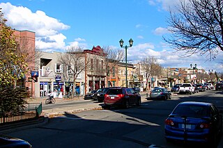
Lachute is a town in southwest Quebec, Canada, 62 km (39 mi) northwest of Montreal, on the Rivière du Nord, a tributary of the Ottawa River, and west of Mirabel International Airport. It is located on Autoroute 50, at the junctions of Quebec Provincial Highways Route 148, Route 158, and Secondary Highways 327 and 329.

Saint-Raymond, also called Saint-Raymond de Portneuf, is a city in Quebec, Canada, located about 63 kilometres (39 mi) north-west of Quebec City. It is the largest city in population and area of the Portneuf Regional County Municipality.
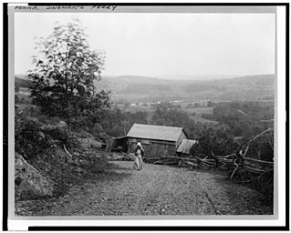
Dingmans Ferry is an unincorporated community in Delaware Township, Pike County, Pennsylvania, United States. As of 2014, it had a population of 7,477 people. It was originally sited on the Delaware River, in an area now included in the Delaware Water Gap National Recreation Area. When the Corps of Engineers acquired the land by eminent domain in the mid-twentieth century for the creation of the proposed Tocks Island Dam project, it relocated the community further up the hill.

Beauport is a borough of Quebec City, Quebec, Canada on the Saint Lawrence River.

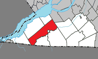
Elgin is a rural municipality in Quebec, Canada. The population as of the Canada 2016 Census was 394. It is located southwest of Huntingdon and bounded by the Trout and Chateauguay rivers and the Canada–United States border.

Hinchinbrooke is a rural community in southern Quebec, in the Châteauguay Valley, in the MRC de Le Haut-Saint-Laurent. The population as of the Canada 2011 Census was 2,242.
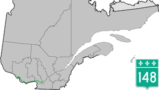
Route 148 is an east-west highway in Quebec, Canada. It runs from junction of Autoroute 13 and Autoroute 440 in Laval in the Montreal region to the Ontario-Quebec border in L'Isle-aux-Allumettes in western Quebec. For most of its length, Route 148 follows the north shore of the Ottawa River where it acted as the principal route between communities in the Outaouais region until the completion of Autoroute 50 in 2012. At the Ontario-Quebec border in L'Isle-aux-Allumettes Route 148 continues into Ontario as Highway 148.
Dickinson Air Force Station is a closed United States Air Force General Surveillance Radar station. It is located 3.8 miles (6.1 km) northeast of Dickinson, North Dakota. It was closed in 1965.
Val Gagné is an unincorporated rural community in the township of Black River-Matheson, Cochrane District, Ontario, Canada. It is located 1.5 km (0.93 mi) east of Highway 11, between Matheson and Iroquois Falls. For many years the community was accessible by train. The Ontario Northland Railway's Northlander from Toronto to Cochrane, which passed through Val Gagné, made its final passenger run in 2012. An Ontario Northland bus now stops at Val Gagné.
Krumville is a hamlet in the southeastern corner of the town of Olive in Ulster County, New York, United States. It takes its name from one of the most prominent of the early Dutch families who settled the area. Krumville is bordered on the northwest by the Olive hamlet of Samsonville, on the north by the hamlet of Olivebridge, on the southeast by the town of Marbletown and on the southwest by the town of Rochester. It lies at an elevation of 774 feet above sea level.

Westphalia is an unincorporated community and census-designated place (CDP) in Vigo Township, Knox County, Indiana. As of the 2010 census it had a population of 202.
Godmanchester is a township municipality located in Le Haut-Saint-Laurent Regional County Municipality in the Montérégie region of Quebec, Canada. The population as of the Canada 2011 Census was 1,417. The southeast part of the township is mostly delineated by the Chateauguay River, while the south end borders with Franklin County, New York.

Shawinigan-Sud is a predominantly French-speaking settlement in the Mauricie area in Quebec, Canada, on the Saint-Maurice River. In 1996, its population was 11,804.

The Rural Municipality of Glen McPherson No. 46 is a rural municipality (RM) in the Canadian province of Saskatchewan within Census Division No. 3 and SARM Division No. 3. It is located in the southwest portion of the province.

The Iron County MRA is a Multiple Resource Area addition to the National Register of Historic Places, which includes 72 separate structures and historic districts within Iron County, Michigan, United States of America. These properties were identified and placed on the Register in 1983, with the exception of one property that was placed on the Register in 1993.

Ortiz is an unincorporated community in Conejos County, in the U.S. state of Colorado. Until 1885 or 1890 Ortiz was called "Los Piños".
Fort Henry is an unincorporated community in Randolph County, in the U.S. state of Missouri. The community is on Missouri Route O approximately 3.5 miles west-northwest of Huntsville.
References
- ↑ Piché, Véronique (31 May 2021). "L'église Knox Church Crystal Falls s'envole en fumée". L’info du Nord Mont-Tremblant. Retrieved 29 March 2022.