
Oakland County is a county in the U.S. state of Michigan. It is part of the metropolitan Detroit area, located northwest of the city. As of the 2020 Census, its population was 1,274,395, making it the second-most populous county in Michigan, behind neighboring Wayne County. It is the largest county in the United States without a city of 100,000 residents. The county seat is Pontiac. The county was founded in 1819 and organized in 1820.

Pontiac is a city in and the county seat of Oakland County in the U.S. state of Michigan. As of the 2020 census, the city had a total population of 61,606. A northern suburb of Metro Detroit, Pontiac is about 20 miles (32.2 km) northwest of Detroit.

Waterford Township is a charter township in the geographic center of Oakland County, Michigan, United States.

M-1, commonly known as Woodward Avenue, is a north–south state trunkline highway in the Metro Detroit area of the US state of Michigan. The highway, called "Detroit's Main Street", runs from Detroit north-northwesterly to Pontiac. It is one of the five principal avenues of Detroit, along with Michigan, Grand River, Gratiot, and Jefferson avenues. These streets were platted in 1805 by Judge Augustus B. Woodward, namesake to Woodward Avenue. The Federal Highway Administration (FHWA) has listed the highway as the Automotive Heritage Trail, an All-American Road in the National Scenic Byways Program. It has also been designated a Pure Michigan Byway by the Michigan Department of Transportation (MDOT), and was also included in the MotorCities National Heritage Area designated by the US Congress in 1998.

Cass Lake is on the main branch of the Clinton River.
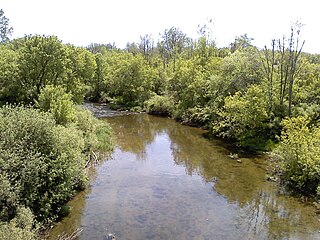
The Clinton River is a river in southeastern Michigan in the United States. It is named in honor of DeWitt Clinton, who was governor of New York from 1817 to 1823.

M-59 is an east–west state trunkline highway that crosses the northern part of Metropolitan Detroit in the US state of Michigan. It runs between Howell at Interstate 96 (I-96) and I-94 on the Chesterfield–Harrison township line near the Selfridge Air National Guard Base. While primarily a multi-lane surface highway, it is a full freeway from just east of downtown Pontiac near Opdyke Road to just east of the Mound Road/Merrill Road exit in Utica. The various surface highway segments are named either Highland Road, Huron Street or Hall Road, with the latter known as an area for shopping and dining. The rural sections west of Pontiac pass through Oakland County lake country crossing through two state recreational areas.

US Highway 24 is a United States Numbered Highway that runs from Minturn, Colorado, to Independence Township, Michigan. In Michigan, it is also known as Telegraph Road and runs for 79.828 miles (128.471 km) as a major north–south state trunkline highway from Bedford Township at the Ohio state line through Metro Detroit. The highway runs through three counties in southeastern Michigan, Monroe, Wayne and Oakland, as it parallels the Lake Erie shoreline and bypasses Metro Detroit on the west. Telegraph Road connects several suburbs together and passes through the western edge of Detroit before it terminates northwest of Clarkston at an interchange with Interstate 75 (I-75).

Waterford Village is an historic community in Waterford Township, Michigan. First settled in 1819, the village is located in the northernmost part of the township along Dixie Highway, on the southeast shore of Van Norman Lake.
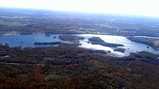
Elizabeth Lake is a freshwater lake located in Waterford Township, Michigan, along the Clinton River. It connects upstream to 90-acre Crescent Lake and downstream to 1,280-acre Cass Lake.
Clintonville is an unincorporated community in Oakland County in the U.S. state of Michigan. The community is located within Waterford Township. As an unincorporated community, Clintonville has no legally defined area or population statistics of its own, and it uses the Waterford 48328 ZIP Code.
Van Norman Lake is a private, all-sports, 66-acre lake along the main branch of the Clinton River, in Oakland County, in the U.S. state of Michigan. Most of the lake lies within Independence Township; however, the southern portion of the lake is in Waterford Township.
Schoolhouse Lake is an all-sports 37-acre lake located in central Oakland County, on the east side of Waterford in Waterford Township.
Sylvan Lake is an all-sports, 458-acre Oakland County, Michigan lake along the main branch of the Clinton River.
Pontiac Lake is an all-sports, 640-acre Oakland County, Michigan lake along the Huron River. The lake lies primarily in White Lake Township, while a small portion of the lake lies in Waterford Township.
Kent Lake is a 1,200-acre reservoir lake formed by damming the Huron River near its headwaters. Kent Lake is mostly located in Oakland County, Michigan in Milford and Lyon Townships, with a small portion including its dam located in Green Oak Township, Livingston County, Michigan.
Lester Lake is a lake in Oakland County, Michigan lake along the main branch of the Clinton River.
Otter Lake is an all-sports, 74-acre Oakland County, Michigan lake along the main branch of the Clinton River.
Upper Silver Lake is a 35.5-acre (14.4 ha) lake located in Waterford Township, Michigan in Oakland County, Michigan.
White Horse Lake is a lake located in Waterford Township, Michigan. It lies east of Hospital Rd., north of Elizabeth Lake Rd. and south of Pontiac Lake Rd.
