Csépa

Last updated
Csépa
Village
Coa Hungary Town Csepa big.svg
Coat of arms
Hungary location map.svg
Red pog.svg
Csépa
Coordinates: 46°48′24″N20°07′52″E / 46.80667°N 20.13111°E / 46.80667; 20.13111 Coordinates: 46°48′24″N20°07′52″E / 46.80667°N 20.13111°E / 46.80667; 20.13111
Country Flag of Hungary.svg  Hungary
County Jász-Nagykun-Szolnok
District Kunszentmárton
Area
  Total 29.67 km2 (11.46 sq mi)
Population (2015)
  Total 1,642 [1]
  Density 55.3/km2 (143/sq mi)
Time zone CET (UTC+1)
  Summer (DST) CEST (UTC+2)
Postal code 5475
Area code(s) (+36) 56

Csépa is a village in Jász-Nagykun-Szolnok county, in the Northern Great Plain region of central Hungary.

Village Small clustered human settlement smaller than a town

A village is a clustered human settlement or community, larger than a hamlet but smaller than a town, with a population ranging from a few hundred to a few thousand. Though villages are often located in rural areas, the term urban village is also applied to certain urban neighborhoods. Villages are normally permanent, with fixed dwellings; however, transient villages can occur. Further, the dwellings of a village are fairly close to one another, not scattered broadly over the landscape, as a dispersed settlement.

Northern Great Plain Region in Hungary

The Northern Great Plain is a statistical region of Hungary. It is part of the Great Plain and North region. The Northern Great Plain includes the counties of Hajdú-Bihar, Jász-Nagykun-Szolnok, and Szabolcs-Szatmár-Bereg, with a total area of 17,749 km2 (6,853 sq mi) and a population of around 1.5 million.

In geography, regions are areas that are broadly divided by physical characteristics, human impact characteristics, and the interaction of humanity and the environment. Geographic regions and sub-regions are mostly described by their imprecisely defined, and sometimes transitory boundaries, except in human geography, where jurisdiction areas such as national borders are defined in law.

Contents

Geography

It covers an area of 29.67 km2 (11 sq mi) and has a population of 1642 people (2015). [1]

Area quantity that expresses the extent of a two-dimensional surface or shape, or planar lamina, in the plane

Area is the quantity that expresses the extent of a two-dimensional figure or shape, or planar lamina, in the plane. Surface area is its analog on the two-dimensional surface of a three-dimensional object. Area can be understood as the amount of material with a given thickness that would be necessary to fashion a model of the shape, or the amount of paint necessary to cover the surface with a single coat. It is the two-dimensional analog of the length of a curve or the volume of a solid.

Population All the organisms of a given species that live in the specified region

In biology, a population is the number of all the organisms of the same group or species, which live in a particular geographical area, and have the capability of interbreeding. The area of a sexual population is the area where inter-breeding is potentially possible between any pair within the area, and where the probability of interbreeding is greater than the probability of cross-breeding with individuals from other areas.

Related Research Articles

Central Europe region of Europe

Central Europe is the region comprising the central part of Europe. It is said to occupy continuous territory that are otherwise conventionally Western Europe, Southern Europe, and Eastern Europe. The concept of Central Europe is based on a common historical, social and cultural identity. Central Europe is going through a phase of "strategic awakening", with initiatives such as the CEI, Centrope and the Visegrád Four. While the region's economy shows high disparities with regard to income, all Central European countries are listed by the Human Development Index as very highly developed.

Hungary Country in Central Europe

Hungary is a country in Central Europe. Spanning 93,030 square kilometres (35,920 sq mi) in the Carpathian Basin, it borders Slovakia to the north, Ukraine to the northeast, Austria to the northwest, Romania to the east, Serbia to the south, Croatia to the southwest, and Slovenia to the west. With about 10 million inhabitants, Hungary is a medium-sized member state of the European Union. The official language is Hungarian, which is the most widely spoken Uralic language in the world. Hungary's capital and its largest city and metropolis is Budapest. Other major urban areas include Debrecen, Szeged, Miskolc, Pécs and Győr.

Visegrád Group intergovernmental organization

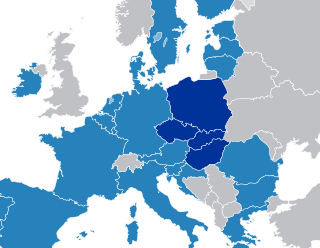
The Visegrád Group, Visegrád Four, or V4 is a cultural and political alliance of four Central European states – the Czech Republic, Hungary, Poland and Slovakia, that are members of the European Union (EU) and NATO – for the purposes of advancing military, cultural, economic and energy cooperation with one another along with furthering their integration in the EU.

Budapest Capital city in Hungary

Budapest is the capital and the most populous city of Hungary, and the tenth-largest city in the European Union by population within city limits. The city had an estimated population of 1,752,704 in 2016 distributed over a land area of about 525 square kilometres. Budapest is both a city and county, and forms the centre of the Budapest metropolitan area, which has an area of 7,626 square kilometres and a population of 3,303,786, comprising 33 percent of the population of Hungary.

Telkibánya Village in Northern Hungary, Hungary

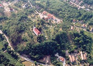
Telkibánya is a village in Borsod-Abaúj-Zemplén county, in the Northern Hungary region of northeastern Hungary.

Rakamaz Place in Northern Great Plain, Hungary

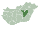
Rakamaz is a town in Szabolcs-Szatmár-Bereg county, in the Northern Great Plain region of eastern Hungary.

Vámosoroszi Place in Northern Great Plain, Hungary

Vámosoroszi is a village in Szabolcs-Szatmár-Bereg county, in the Northern Great Plain region of eastern Hungary.

Vállaj Place in Northern Great Plain, Hungary

Vállaj is a village in Szabolcs-Szatmár-Bereg county, in the Northern Great Plain region of eastern Hungary.

Túrricse Place in Northern Great Plain, Hungary

Túrricse is a village in Szabolcs-Szatmár-Bereg county, in the Northern Great Plain region of eastern Hungary.

Tunyogmatolcs Place in Northern Great Plain, Hungary

Tunyogmatolcs is a village in Szabolcs-Szatmár-Bereg county, in the Northern Great Plain region of eastern Hungary.

Tornyospálca Place in Northern Great Plain, Hungary

Tornyospálca is a village in Szabolcs-Szatmár-Bereg county, in the Northern Great Plain region of eastern Hungary.

Tiszaszentmárton Place in Northern Great Plain, Hungary

Tiszaszentmárton is a village in Szabolcs-Szatmár-Bereg county, in the Northern Great Plain region of eastern Hungary.

Tiszarád Place in Northern Great Plain, Hungary

Tiszarád is a village in Szabolcs-Szatmár-Bereg county, in the Northern Great Plain region of eastern Hungary.

Tiszanagyfalu Place in Northern Great Plain, Hungary

Tiszanagyfalu is a village in Szabolcs-Szatmár-Bereg county, in the Northern Great Plain region of eastern Hungary.

Tiszabercel Place in Northern Great Plain, Hungary

Tiszabercel is a village in Szabolcs-Szatmár-Bereg county, in the Northern Great Plain region of eastern Hungary.

Tiborszállás Place in Northern Great Plain, Hungary

Tiborszállás is a village in Szabolcs-Szatmár-Bereg county, in the Northern Great Plain region of eastern Hungary.

Tarpa Place in Northern Great Plain, Hungary

Tarpa is a village in Szabolcs-Szatmár-Bereg county, in the Northern Great Plain region of eastern Hungary.

Szamostatárfalva Place in Northern Great Plain, Hungary

Szamostatárfalva is a village in Szabolcs-Szatmár-Bereg county, in the Northern Great Plain region of eastern Hungary.

Szamosszeg Place in Northern Great Plain, Hungary

Szamosszeg is a village in Szabolcs-Szatmár-Bereg county, in the Northern Great Plain region of eastern Hungary.

Szamosbecs Place in Northern Great Plain, Hungary

Szamosbecs is a village in Szabolcs-Szatmár-Bereg county, in the Northern Great Plain region of eastern Hungary.

References

  1. 1 2 Gazetteer of Hungary, 1st January 2015 . Hungarian Central Statistical Office. 03/09/2015