Saint Lucia is an island country in the West Indies in the eastern Caribbean Sea on the boundary with the Atlantic Ocean. The island was previously called Iyonola, the name given to the island by the native Arawaks, and later Hewanorra, the name given by the native Caribs, two separate Amerindian peoples. Part of the Windward Islands of the Lesser Antilles, it is located north/northeast of the island of Saint Vincent, northwest of Barbados and south of Martinique. It covers a land area of 617 km2 and reported a population of 165,595 in the 2010 census. Its capital is Castries. Soufrière was colonized by the French and was the original capital of the island.

Saint Lucia was inhabited by the Arawak and Kalinago Caribs before European contact in the early 16th century. It was colonized by the British and French in the 17th century and was the subject of several possession changes until 1814, when it was ceded to the British by France for the final time. In 1958, St. Lucia joined the short-lived semi-autonomous West Indies Federation. Saint Lucia was an associated state of the United Kingdom from 1967 to 1979 and then gained full independence on February 22, 1979.

Saint Lucia is one of many small land masses composing the insular group known as the Windward Islands. Unlike large limestone areas such as Florida, Cuba, and the Yucatan Peninsula, or the Bahamas, which is a small island group composed of coral and sand, St. Lucia is a typical Windward Island formation of volcanic rock that came into existence long after much of the region had already been formed.

Castries, population 20,000, aggl. 53,639, is the capital and largest city of Saint Lucia, an island country in the Caribbean. The quarter with the same name had a population of 70,000 on 22 May 2013 and stretches over an area of 80 km2 (31 sq mi).

The Saint Lucia Football Association is the governing body of football in Saint Lucia. The FA was founded in 1979, the same year the island gained independence, and is headquartered in Castries, the nation's capital. It runs the Saint Lucia men's and women's junior and senior national teams, as well as its domestic football competitions, which include both men's and women's professional leagues and youth championships.

The House of Assembly is the lower house of the Parliament of Saint Lucia, elected by popular vote. The upper house is the Senate. It has 17 or 18 members: 17 members elected for a five-year term in single-seat constituencies, and a speaker elected by the 17 members, who may be one of their number or a person chosen from outside the House.

Philip Joseph Pierre is a Saint Lucian politician currently serving as the prime minister of Saint Lucia since 28 July 2021 and Leader of the Saint Lucia Labour Party since 18 June 2016. He has represented the Castries East constituency in the House of Assembly since 1997.

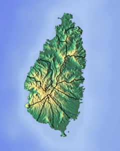
The Canelles River is a river in Saint Lucia. It flows southeast from the central highlands in the south of the island, reaching the Atlantic Ocean to the south of the town of Micoud.
The Roseau River is a river in the Anse-la-Raye Quarter of the island country of Saint Lucia. It flows north and then west from the central highlands in the south of the island, reaching the Caribbean Sea to the north of the town of Anse la Raye. The Roseau river is also the longest in the country and is dammed by the John Compton Dam near Millet.
The Balembouche River is a coastal river in Laborie Quarter, Saint Lucia that flows into the Caribbean Sea.
The Castries River is a river in Castries Quarter on the island county of Saint Lucia.
The Choc River is a river in the Soufrière Quarter of the island country of Saint Lucia. It flows to the Caribbean Sea.
The Esperance River is a river in Gros Islet Quarter in the island country of Saint Lucia.
The Louvet River is a river of Saint Lucia. It drains from the forest area to the east coast.

The Capture of St Lucia was the result of a campaign from 18–28 December 1778 by British land and naval forces to take over the island, which was a French colony. Britain's actions followed the capture of the British-controlled island of Dominica by French forces in a surprise invasion in September 1778. During the Battle of St. Lucia, the British fleet defeated a French fleet sent to reinforce the island. A few days later French troops were soundly defeated by British troops during the Battle of Morne de la Vierge. Realising that another British fleet would soon arrive with reinforcements, the French garrison surrendered. The remaining French troops were evacuated, and the French fleet returned to Martinique, another French colony. St. Lucia stayed in the hands of the British.
Indo–Saint Lucians or Indian–Saint Lucians, are Saint Lucians whose ancestry lies within the country of India, primarily the modern-day Indian states of Bihar, Jharkhand and Uttar Pradesh in Northern India. In 1859, the British began transporting indentured workers from British India to work on plantation estates in Saint Lucia, which had become a British colony in 1814. The first ship carrying 318 indentured workers from India, the Palmyra, arrived in Saint Lucia on 6 May 1859, and the last ship carrying Indian indentured workers, the Volga, arrived on 10 December 1893.
Saint Lucian nationality law is regulated by the Saint Lucia Constitution Order of 1978, as amended; the Citizenship of Saint Lucia Act of 1979, and its revisions; and various British Nationality laws. These laws determine who is, or is eligible to be, a national of Saint Lucia. Saint Lucian nationality is typically obtained either on the principle of jus soli, i.e. by birth in Saint Lucia; or under the rules of jus sanguinis, i.e. by birth abroad to parents with Saint Lucian nationality. It can be granted to persons with an affiliation to the country, or to a permanent resident who has lived in the country for a given period of time through naturalisation. There is also, currently a program in Saint Lucia for persons to acquire nationality through investment in the country. Nationality establishes one's international identity as a member of a sovereign nation. Though it is not synonymous with citizenship, for rights granted under domestic law for domestic purposes, the United Kingdom, and thus the commonwealth, have traditionally used the words interchangeably.

Ti Rocher is a settlement on the island of Saint Lucia.