Cumberland Homesteads

Last updated
Cumberland Homesteads Historic District
Cumberland-homesteads-tower-tn1.jpg
Homesteads Tower
USA Tennessee location map.svg
Red pog.svg
Usa edcp location map.svg
Red pog.svg
LocationRoughly along County Seat and Valley Rds., Grassy Cove Rd., Deep Draw and Pigeon Ridge Rds.
Nearest city Crossville, Tennessee
Coordinates 35°54′22″N84°58′58″W / 35.90611°N 84.98278°W / 35.90611; -84.98278
Area10,250 acres (4,150 ha) [1]
Built19341941
ArchitectWilliam Macy Stanton [1]
Architectural style FSA small house
NRHP reference No. 88001593 [2]
Added to NRHPSeptember 30, 1988

Cumberland Homesteads is a community located in Cumberland County, Tennessee, United States. Established by the New Deal-era Division of Subsistence Homesteads in 1934, the community was envisioned by federal planners as a model of cooperative living for the region's distressed farmers, coal miners, and factory workers. While the cooperative experiment failed and the federal government withdrew from the project in the 1940s, the Homesteads community nevertheless survived. In 1988, several hundred of the community's original houses and other buildings, which are characterized by the native "crab orchard" sandstone used in their construction, were added to the National Register of Historic Places as a historic district. [3]

Contents

By the early 1930s, decades of poor farming practices had rendered many of the small farms in East Tennessee untenable, and the Great Depression had left thousands of coal miners and other industrial workers unemployed. In January 1934, the Division of Subsistence Homesteads chose Cumberland County as a site for one of its "stranded" agricultural communities, in which families were resettled on small farms and would work in community-owned businesses. Most of the cooperative ventures failed, however, and after World War II the government divested itself of the project. The community's general layout still appears much as it did in the late 1930s. [3]

Location

Cumberland Homesteads is located in a hilly area atop the Cumberland Plateau, just south of Crossville. Byrd Creek, a tributary of the Obed River, flows through and drains much of the community. Cumberland Mountain State Park, which was developed simultaneously in the 1930s as a recreational area, is located in Cumberland Homesteads.

U.S. Route 127 connects the Homestead area with Crossville and Interstate 40 to the north and the Sequatchie Valley to the south. State Route 68 (Grassy Cove Road) connects the area to Grassy Cove and Spring City to the east. The Cumberland Homesteads Historic District, which covers over 10,000 acres (40 km2), includes properties on Chestnut Lane, Coon Hollow Lane, County Seat Road, Crab Apple Lane, Crab Orchard Road, Deep Draw Road, Grassy Cove Road (State Route 68), Highland Lane, Huckleberry Road, Old Mail Road, Open Range Road, Pigeon Ridge Road (State Route 419), Saw Mill Road, Turkey Oak Road, and Valley Road, as well as over a dozen structures in Cumberland Mountain State Park. [1]

Site plan for Cumberland Homesteads Cumberland-homesteads-aerial-view-tn1.jpg
Site plan for Cumberland Homesteads

Conception

The passage of the National Industrial Recovery Act in 1933 created the Division of Subsistence Homesteads and gave the Roosevelt Administration $25,000,000 to purchase land for the creation of small farming communities for the nation's displaced workers. Cumberland County farm agent Robert Lyons led a local committee that drew up a proposal for a homestead community, which it submitted to the Division of Subsistence Homesteads in December 1933. Lyons had likely been influenced by earlier Plateau-area "back to the land" experiments, such as the Clifty Consolidated Coal Company's 1917 program that helped Fentress County miners purchase small farms, [4] as well as relief efforts provided by local Quakers. [5] Due in part to the influence of Tennessee Valley Authority chairman and cooperative living proponent Arthur Morgan, the Division of Subsistence Homesteads accepted the Cumberland County proposal in January 1934. The Civil Works Administration immediately hired several hundred locals to prepare the newly acquired land, providing wages that effectively ended the Great Depression in Cumberland County. Tennessee Valley Authority (TVA) architect William Macy Stanton, who designed a number of buildings in TVA's planned city of Norris, drew up basic designs for houses and other buildings at the Homesteads. [5] The Civilian Conservation Corps built recreational buildings and a small lake for the community at what is now Cumberland Mountain State Park. By late 1934, the community's first stone houses had been completed. [6]

Intention and Applicants

Overall, Franklin D. Roosevelt came up with the project with grandiose expectations. FDR not only wanted the homes to be comfortable for the tenants, but the community to be utopian like. [7] The Division focused on three types of settlements communities of part-time farmers near wage-earning employment, communities of farmers resettled from unproductive land, and communities of "stranded" industrial workers, namely miners and loggers. The latter type, which eventually included Cumberland Homesteads, drew the most criticism, as many believed such communities would never be self-supporting. [1] Kelly Cox, Director of the Cumberland Homestead Tower Association believes the project was successful because of the dire situation. According to her, the people were desperate for opportunity to work and create a living for themselves. [8]

Crab orchard stone being quarried for Cumberland Homesteads construction Cumberland-homesteads-quarrying-stone-tn1.jpg
Crab orchard stone being quarried for Cumberland Homesteads construction

Over 20,000 acres (81 km2) of land south of Crossville were purchased from the Missouri Land Company, and Cumberland Homesteads, Inc., was created to administer the project. [4]

First Lady Eleanor Roosevelt speaking at Cumberland Homesteads in 1935 Cumberland-homesteads-eleanor-roosevelt-tn1.jpg
First Lady Eleanor Roosevelt speaking at Cumberland Homesteads in 1935

Of the initial 233 families selected for the Cumberland Homesteads project, 30% were distressed farmers, 30% were unemployed miners, 30% were unemployed textile workers, and 10% were struggling professionals (including teachers, nurses, and a doctor). [9]

Success of Project

A community-owned store (the "Trading Post") and cannery were established in 1934, but both struggled with inexperienced management. Wage-paying industries never relocated to the Homesteads as the government had hoped, and attempts by homesteaders to establish a coal mine and sorghum mill failed. Throughout the 1930s, the Homesteads project was overseen by a succession of agencies with differing philosophies, leaving the project without a clear purpose. By 1945, the federal government had extricated itself from the Homesteads project after allowing the remaining homesteaders to purchase their farms. Although the original purpose of the Homesteads project failed, the community survived, and over half the farms remained in the hands of original homesteaders through the 1950s. [10]

Interviews with Local Historians

Today the Cumberland Homestead Tower Association works hard to preserve the rich history of the Cumberland Homestead project. Three individuals who work in the Tower Association were interviewed and were clear in the opportunity that the project provided. Charles Tollett, an Association volunteer, was adamant that the Homesteads were not another Government handout, but an opportunity for Tennessee citizens to work hard for a place to live. [8] From the beginning when the land was cleared and homes were built, the community held a pivotal role. Kelly Cox the Museum Director shared that some eventual tenants were working while two thirds of their credit hours would go towards purchasing a home. [11]

Building designs

A typical Cumberland Homesteads house Cumberland-homesteads-house-tn3.jpg
A typical Cumberland Homesteads house

When establishing the community, its creators were clear in their intention to build with resources local to the area according to Tollett. [8] Buildings at Cumberland Homesteads were constructed using primarily a locally quarried sandstone known as "crab orchard" stone, which is known for its durability and reddish hue in late afternoon sunlight. The most notable building in Cumberland Homesteads is the Homesteads Tower, a cross-shaped building centered around an eight-story octagonal water tower. This building originally housed the Homesteads offices and provided water to the community. Today it is home to the Cumberland Homestead Tower Association which preserves the history of the program. [11] The elementary school and high school, located behind the Homesteads Tower, consists of unique pod-style designs, with detached classrooms and workshops connected by covered walkways. Both school complexes are now part of Homestead Elementary School. The cannery and hosiery mill have both been modified to the extent that they are not considered contributing properties to the historic district, although their respective water towers are considered contributing structures. [1]

Homestead Today

Stone arch bridge over Byrd Creek Deep-draw-road-bridge-tn1.jpg
Stone arch bridge over Byrd Creek

Most of the original 251 houses are still standing. Fifteen distinct housing designs have been identified, with eleven of the designs found multiple times, as they followed basic patterns provided by William Macy Stanton. Stanton's designs include rectangular houses, L-shaped houses, and T-shaped houses, most of which are 1.5 stories with gable roofs and one or two chimneys. Most houses originally had covered-porch entrances and batten doors. [1] Typical interiors consisted of pine paneling with built-in bookcases. Attics contained water storage tanks, and most houses were wired in anticipation of TVA providing electrical power. [6] Most farmsteads included a barn (with either gable or gambrel-roof design), a smokehouse, a chicken house, and toolsheds. [1]

The Cumberland Homesteads Historic District includes several structures at Cumberland Mountain State Park, including Byrd Creek Dam, Millhouse Lodge (originally a gristmill designed by Quakers), several rustic cabins, and a stone water tower. Byrd Creek Dam is the largest masonry structure ever built by the Civilian Conservation Corps. [12] Two stone arch bridges, one along Deep Draw Road and one along Old Mail Road, are listed as contributing structures within the district. [1]

Related Research Articles

<span class="mw-page-title-main">Cumberland County, Tennessee</span> County in Tennessee, United States

Cumberland County is a county located in the U.S. state of Tennessee. As of the 2020 census, the population was 61,145. Its county seat is Crossville. Cumberland County comprises the Crossville, TN micropolitan statistical area.

<span class="mw-page-title-main">Norris, Tennessee</span> City in Tennessee, United States

Norris is a city in Anderson County, Tennessee. Its population was 1,599 at the 2020 census. It is included in the Knoxville, TN Metropolitan Statistical Area.

<span class="mw-page-title-main">Crab Orchard, Tennessee</span> City in Tennessee, United States

Crab Orchard is a city in Cumberland County, Tennessee, United States. The population was 719 at the 2020 census.

<span class="mw-page-title-main">Crossville, Tennessee</span> City in Tennessee, United States

Crossville is a city in and the county seat of Cumberland County, Tennessee, United States. It is part of the Crossville Micropolitan Statistical Area. The population was 12,071 at the 2020 census.

<span class="mw-page-title-main">Pleasant Hill, Tennessee</span> Town in Tennessee, United States

Pleasant Hill is a town in Cumberland County, Tennessee, United States. The population was 563 at the 2010 census.

<span class="mw-page-title-main">Rugby, Tennessee</span> Historic house in Tennessee, United States

Rugby is an unincorporated community in Morgan and Scott counties in the U.S. state of Tennessee. Founded in 1880 by English author Thomas Hughes, Rugby was built as an experimental utopian colony. While Hughes's experiment largely failed, a small community lingered at Rugby throughout the 20th century. In the 1960s, residents, friends and descendants of Rugby began restoring the original design and layout of the community, preserving surviving structures and reconstructing others. Rugby's Victorian architecture and picturesque setting have since made it a popular tourist attraction. In 1972, Rugby's historic area was listed under the name Rugby Colony on the National Register of Historic Places as a historic district.

<span class="mw-page-title-main">Caney Fork River</span> River in Tennessee, United States

The Caney Fork River is a river that flows through central Tennessee in the United States, draining a substantial portion of the southwestern Cumberland Plateau and southeastern Highland Rim regions. It is a major tributary of the Cumberland River, and is part of the Cumberland, Ohio and Mississippi basins. The river is 143 miles (230 km) long, and its watershed covers 1,771 square miles (4,590 km2) in eleven counties. Monterey, Baxter, Sparta, Smithville, McMinnville, Altamont, Spencer and Gordonsville are among the towns that are at least partially drained by the river.

<span class="mw-page-title-main">Melton Hill Dam</span> Dam in Tennessee and Lenoir City, Tennessee

Melton Hill Dam is a hydroelectric dam on the Clinch River just south of Oak Ridge, Tennessee, United States. The dam is operated by the Tennessee Valley Authority, which built the dam in the early 1960s to extend the Tennessee Valley's continuous navigation channel up the Clinch as far as Clinton and to increase TVA's overall power-generating capacity. The dam impounds the 5,470-acre (2,210 ha) Melton Hill Lake, and is the only TVA tributary dam serviced by a navigation lock. The dam and associated infrastructure were listed on the National Register of Historic Places in 2017.

<span class="mw-page-title-main">Resettlement Administration</span>

The Resettlement Administration (RA) was a New Deal U.S. federal agency created May 1, 1935. It relocated struggling urban and rural families to communities planned by the federal government. On September 1, 1937, it was succeeded by the Farm Security Administration.

<span class="mw-page-title-main">Cumberland Mountain State Park</span> State park in Tennessee, United States

Cumberland Mountain State Park is a state park in Cumberland County, Tennessee, in the southeastern United States. The park consists of 1,720 acres (7.0 km2) situated around Byrd Lake, a man-made lake created by the impoundment of Byrd Creek in the 1930s. The park is set amidst an environmental microcosm of the Cumberland Plateau and provides numerous recreational activities, including an 18-hole Bear Trace golf course.

<span class="mw-page-title-main">Arthurdale, West Virginia</span> Unincorporated community in West Virginia, United States

Arthurdale is an unincorporated community in Preston County, West Virginia, United States. It was built in 1933 at the height of the Great Depression as a social experiment to provide opportunities for unemployed local miners and farmers. Arthurdale was undertaken by the short-lived Subsistence Homesteads Division and with the personal involvement of First Lady Eleanor Roosevelt, who used her influence to win government approval for the scheme.

Concord is an unincorporated community in Knox County, Tennessee, United States and is listed on the National Register of Historic Places as a historic district, the Concord Village Historic District. The United States Geographic Names Information System classifies Concord as a populated place. It is located in western Knox County, east of Farragut and west of Knoxville. Mail destined for Concord is now addressed to Concord, Knoxville, or Farragut.

<span class="mw-page-title-main">Cove Lake State Park</span> State park in Tennessee, United States

Cove Lake State Park is a state park in Campbell County, Tennessee, in the southeastern United States. The park consists of 673 acres (2.72 km2) situated around Cove Lake, an impoundment of Cove Creek created by the completion of Caryville Dam in 1936. The park's location is adjacent to the town of Caryville and just west of Jacksboro.

<span class="mw-page-title-main">Ozone Falls State Natural Area</span>

Ozone Falls State Natural Area is a state natural area in Cumberland County, Tennessee in the southeastern United States. It consists of 43 acres (0.17 km2) centered on Ozone Falls, a 110-foot (34 m) plunge waterfall, and its immediate gorge along Fall Creek. Because of its picturesque beauty and easy access, Disney selected Ozone Falls for scenes for their live-action film "Rudyard Kipling's The Jungle Book". The area is managed by the Tennessee Department of Environment and Conservation and maintained by Cumberland Mountain State Park. It is also part of Cumberland Trail State Park.

<span class="mw-page-title-main">Sgt. Alvin C. York State Historic Park</span>

Sgt. Alvin C. York State Historic Park is a state park in Pall Mall, in the U.S. state of Tennessee. Situated along the Wolf River, the park contains the farm and gristmill once owned by decorated World War I soldier Alvin C. York (1887–1964), who lived in the Pall Mall area for his entire life. Along with the millhouse and milldam, the park includes York's two-story house, York's general store and post office, the Wolf River Cemetery, the Wolf River Methodist Church, the York Bible Institute, and various picnic facilities.

<span class="mw-page-title-main">Norvelt, Pennsylvania</span> Census-designated place in Pennsylvania, United States

Norvelt is a census-designated place in Mount Pleasant Township, Westmoreland County, Pennsylvania, United States, founded in 1934 as Westmoreland Homesteads. In 1937 it was renamed to honor Eleanor Roosevelt. The community was part of the Calumet-Norvelt CDP for the 2000 census, but was split into the two separate communities of Calumet and Norvelt for the 2010 census. Calumet was a typical company town, locally referred to as a "patch" or "patch town", built by a single company to house coal miners as cheaply as possible. On the other hand, Norvelt was created during the Great Depression by the federal government of the United States as a model community, intended to increase the standard of living of laid-off coal miners. Award winning writer Jack Gantos was born in the village and wrote two books about it

<span class="mw-page-title-main">Grassy Cove</span> Geographical region in Cumberland County, Tennessee, United States

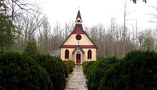
Grassy Cove is an enclosed valley in Cumberland County, Tennessee, United States. The valley is notable for its karst formations, which have been designated a National Natural Landmark. Grassy Cove is also home to a small unincorporated community.

<span class="mw-page-title-main">Hiwassee Dam</span> Dam in North Carolina, United States

Hiwassee Dam is a hydroelectric dam on the Hiwassee River in Cherokee County, in the U.S. state of North Carolina. It is one of three dams on the river owned and operated by the Tennessee Valley Authority, which built the dam in the late 1930s to bring flood control and electricity to the region. The dam impounds the Hiwassee Lake of 6,000 acres (2,400 ha), and its tailwaters are part of Apalachia Lake. At 307 feet (94 m), Hiwassee Dam is the third highest dam in the TVA system, behind only Fontana and Watauga. The dam and associated infrastructure was listed on the National Register of Historic Places in 2017.

<span class="mw-page-title-main">Subsistence Homesteads Division</span> US federal agency of the 1930s known as DSH

The Subsistence Homesteads Division of the United States Department of the Interior was a New Deal agency that was intended to relieve industrial workers and struggling farmers from complete dependence on factory or agricultural work. The program was created to provide low-rent homesteads, including a home and small plots of land that would allow people to sustain themselves. Through the program, 34 communities were built. Unlike subsistence farming, subsistence homesteading is based on a family member or members having part-time, paid employment. However the new resident were not allowed to purchase the new homes.

<span class="mw-page-title-main">Palace Theater (Crossville, Tennessee)</span> United States historic place

The Palace Theater at 210 N. Main St. in Crossville, Tennessee is a historic movie theater built in the 1930s.

References

  1. 1 2 3 4 5 6 7 8 Elizabeth Straw, National Register of Historic Places Nomination Form for Cumberland Homesteads Historic District, May 1988.
  2. "National Register Information System". National Register of Historic Places . National Park Service. July 9, 2010.
  3. 1 2 Elizabeth Straw, Cumberland Homesteads. Tennessee Encyclopedia of History and Culture, 2002. Retrieved: 30 March 2010.
  4. 1 2 James Collins Moore, An Analysis of the New Deal Subsistence Homesteads Program in Cumberland County, Tennessee: A Thesis Presented to the Faculty of the Graduate School, Tennessee Technological University (Cookeville, Tenn.: 1967), pp. 1-5.
  5. 1 2 Edna Gossage Blue, "The Man Stanton," Looking Back: Cumberland Homesteads Golden Anniversary Album (Crossville, Tenn.: E.J.P. Vaden, 1984), p. 6.
  6. 1 2 Emma Jean Pedigo Vaden, Looking Back: Cumberland Homesteads Golden Anniversary Album (Crossville, Tenn.: E.J.P. Vaden, 1984), pp. 11-19.
  7. Austin, Linda T. (2009). "Unrealized Expectations: Cumberland, The New Deal's Only Homestead Project". Tennessee Historical Quarterly. 68 (4): 433–450. ISSN   0040-3261. JSTOR   42628718.
  8. 1 2 3 Cumberland Homesteads | Cumberland County | #DiscoverUC , retrieved 2022-04-28
  9. Moore, thesis, pp. 6-9.
  10. Moore, thesis, pp. 13-26.
  11. 1 2 History lives on at Cumberland Homesteads , retrieved 2022-04-28
  12. Carroll Van West, Cumberland Mountain State Park. Tennessee Encyclopedia of History and Culture, 2002. Retrieved: 1 April 2010.