
Yarmouth is a town in Cumberland County, Maine, United States, twelve miles north of the state's largest city, Portland. When originally settled in 1636, as North Yarmouth, it was part of the Massachusetts Bay Colony, and remained part of its subsequent incarnations for 213 years. In 1849, twenty-nine years after Maine's admittance to the Union as the twenty-third state, it was incorporated as the Town of Yarmouth.
The historical buildings and structures of Yarmouth, Maine, represent a variety of building styles and usages, largely based on its past as home to almost sixty mills over a period of roughly 250 years. These mills include that of grain, lumber, pulp and cotton. Additionally, almost three hundred vessels were launched by Yarmouth's shipyards in the century between 1790 and 1890, and the homes of master shipwrights and ship captains can still be found throughout the town.
The history of Yarmouth, Maine, is closely tied to its position on the banks of the Royal River and its proximity to Casco Bay, an inlet of the Gulf of Maine, itself a gulf of the Atlantic Ocean.
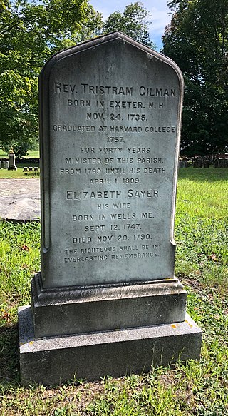
Tristram Gilman was an American Congregational minister who served as the fourth pastor of the "Old Ledge" meetinghouse in what was then North Yarmouth, Massachusetts, for forty years. Gilman Road, adjacent to where the church formerly stood, is now named for him.

Main Street is a historic street in Yarmouth, Maine, United States. It is part of the 18-mile-long (29 km) State Route 115 (SR 115), the eastern terminus of which is in Yarmouth at the intersection of Marina Road and Lafayette Street (SR 88), at Yarmouth Harbor in the Lower Falls area. Its western end is a merging with Walnut Hill Road in North Yarmouth, at which point SR 115 continues west.

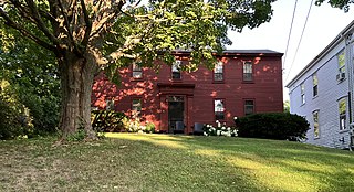
Pioneer Cemetery, also known as the Pioneers Burial Ground and the Indian Fighters Cemetery, is a historic cemetery in Yarmouth, Maine, United States. Dating to 1731, it was the first public burial place in Old North Yarmouth, which was then part of the Province of Massachusetts Bay. It stands on Gilman Road, around 450 feet (140 m) northeast of the Ledge Cemetery, and almost directly across Gilman Road from the Cutter House, which was completed a year earlier.
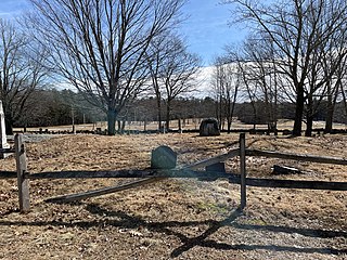
Ledge Cemetery, also known as the Cemetery under the Ledge, is a historic cemetery in Yarmouth, Maine, United States. Dating to 1770, it stands on Gilman Road, around 450 feet (140 m) southwest of the older and smaller Pioneer Cemetery. Some headstones bear dates earlier than 1770, for many burials — such as that of Revd. Nicholas Loring — were removed from the older cemetery
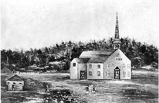
The Meetinghouse under the Ledge, also known as the Old Ledge Meetinghouse, was a church that stood in present-day Yarmouth, Maine, between 1729 and 1836. It was the ninth church founded in Maine.

Ammi Ruhamah Cutter was an American Congregational minister who served as the first pastor of the "Old Ledge" meetinghouse in what was then North Yarmouth, Province of Massachusetts Bay.
Nicholas Loring was an American Congregational minister who served as the second pastor of the "Old Ledge" meetinghouse in what was then North Yarmouth, Province of Massachusetts Bay. He died while in the 28th year of his tenure.
Ammi Ruhamah Mitchell was an 18th- and 19th-century American physician. He also served ten years in the Massachusetts Legislature.
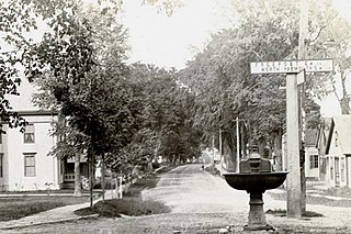
Elm Street is a prominent street in Yarmouth, Maine, United States. It runs for about 2.7 miles (4.3 km) from North Road in the north to Portland Street in the south. The street's addresses are split between "West Elm Street" and "East Elm Street", the transition occurring at Main Street in the Upper Village. Several of its buildings are homes dating to the late 18th and early 19th centuries.
The Johnathan True House is a historic home at 43 East Main Street in the Lower Falls area of Yarmouth, Maine. Built in 1780, before Yarmouth's secession from North Yarmouth, it is one of the oldest surviving buildings in the town. Between 1780 and the turn of the 19th century, Lower Falls saw an increase in its population after early settlers gradually moved inland from the area around the Meetinghouse under the Ledge on Gilman Road.

35 East Main Street, also known as the Jeremiah Baker House, is a historic four-storey home at 35 East Main Street in the Lower Falls area of Yarmouth, Maine. Between 1780 and the turn of the 19th century, Lower Falls saw an increase in its population after early settlers gradually moved inland from the area around the Meetinghouse under the Ledge on Gilman Road. Built in 1848, possibly for William Stockbridge, before Yarmouth's secession from North Yarmouth, the home overlooks Yarmouth Marina, which was a bustling working harbor from the early to late 19th century, and the area of the harbor historically known as Grantville. It stands adjacent to the Johnathan True House.

108 Main Street is a historic three-storey building in the Lower Falls area of Yarmouth, Maine. Between 1780 and the turn of the 19th century, Lower Falls saw an increase in its population after early settlers gradually moved inland from the area around the Meetinghouse under the Ledge on Gilman Road.

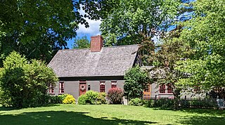
The Gilman Manse is an historic home at 463 Lafayette Street in Yarmouth, Maine. Built in 1771, making it one of the oldest extant buildings in the town, it was originally the home of Tristram Gilman, the fourth minister of the now-demolished Meetinghouse under the Ledge, which stood around 900 feet (270 m) to the northeast between 1729 and 1836. It succeeded the Cutter House, at 60 Gilman Road, as the parsonage for the church.
Gilman Road is a prominent street in Yarmouth, Maine, United States. It runs for about 1.7 miles (2.7 km) from Lafayette Street in the northwest to the Ellis C. Snodgrass Memorial Bridge at White's Cove in the southeast. At the bridge, which connects the Yarmouth mainland to Cousins Island, the road becomes Cousins Road.

Princes Point Road is a prominent street in Yarmouth, Maine, United States. It runs for about 1.93 miles (3.11 km) from Lafayette Street in the north to Sunset Point Road in the south. It was one of the first streets laid out in the town when it was centered around the Meetinghouse under the Ledge in the 18th century. Gilman Road, another of the early roads in the area, intersects Princes Point Road near its northern end.

Drinkwater Point Road is a prominent street in Yarmouth, Maine, United States. One of the first streets laid out in what was then coastal North Yarmouth, Province of Massachusetts Bay, it runs for about 0.45 miles (0.72 km) from Gilman Road in the north to Seaborne Drive in the south. Drinkwater Point faces Cousins Island, to which it is connected by the Ellis C. Snodgrass Memorial Bridge, and overlooks inner Casco Bay.
Jacob Curry Mitchell was an American deacon who became prominent in what is now North Yarmouth, Maine.


 The home faces the Pioneer Cemetery