Pioneer Cemetery (Yarmouth, Maine)

Last updated
Pioneer Cemetery
Pioneer Cemetery (Yarmouth, Maine) 1.jpg
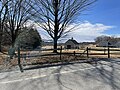
The cemetery in 2022. The memorial plaque on the boulder replaced an earlier one that was deemed offensive to some
Pioneer Cemetery (Yarmouth, Maine)
Details
Established1731(292 years ago) (1731)
Location
Gilman Road
Yarmouth, Maine
CountryUnited States
Coordinates 43°47′08″N70°10′25″W / 43.7856°N 70.1735°W / 43.7856; -70.1735
Owned byTown of Yarmouth
Size0.5 acres (0.20 ha)
Find a Grave Pioneer Cemetery

Pioneer Cemetery, also known as the Pioneers Burial Ground and the Indian Fighters Cemetery, is a historic cemetery in Yarmouth, Maine, United States. [1] Dating to 1731, it was the first public burial place in Old North Yarmouth, which was then part of the Province of Massachusetts Bay. [2] It stands on Gilman Road, around 450 feet (140 m) northeast of the Ledge Cemetery, and almost directly across Gilman Road from the Cutter House, which was completed a year earlier.

Contents

Notable burials

Inscriptions recorded by Augustus W. Corliss in his late-19th-century publication Old Times in North Yarmouth, Maine , and later reprinted in Records of the American Catholic Historical Society of Philadelphia, include: [5]

Here Lyes Buried the Body of
Mr. Andrew Ring
Aged 48 years
Died Nove. ye 17, 1744

and

Here Lyes buried ye body
of Capt. Stephen Larrabee
Departed this life
Oct. 20th. anno dom
1737

Marker

The marker for the burial ground, which was attached to a boulder, was removed to the town's historical society in February 2019, having been in place for ninety years, because some people found the term describing the Abenaki Indians tribe "savage enemies" offensive. Information regarding the intended meaning of the text will be displayed alongside it at the museum. [6]

The plaque reads:

Here rest those who in the third and permanent settlement of the town, defended it against the savage enemies, some at the sacrifice of their lives. [6]

Related Research Articles

<span class="mw-page-title-main">Arch Street Friends Meeting House</span> Historic church in Pennsylvania, United States

The Arch Street Meeting House, at 320 Arch Street at the corner of 4th Street in the Old City neighborhood of Philadelphia, Pennsylvania, is a Meeting House of the Religious Society of Friends (Quakers). Built to reflect Friends’ testimonies of simplicity and equality, this building is little changed after more than two centuries of continuous use.

<span class="mw-page-title-main">North Yarmouth and Freeport Baptist Meetinghouse</span> Historic church in Maine, United States

The North Yarmouth and Freeport Baptist Meetinghouse, also known as the Old Baptist Meeting House, is an historic church on Hillside Street in Yarmouth, Maine. Built in 1796 and twice altered in the 19th century, it is believed to be the oldest surviving church built for a Baptist congregation in the state of Maine. It is now owned by the town and maintained by a local non-profit organization.

<span class="mw-page-title-main">Yarmouth, Maine</span> Town in the state of Maine, United States

Yarmouth is a town in Cumberland County, Maine, United States, twelve miles north of the state's largest city, Portland. When originally settled in 1636, as North Yarmouth, it was part of the Massachusetts Bay Colony, and remained part of its subsequent incarnations for 213 years. In 1849, twenty-nine years after Maine's admittance to the Union as the twenty-third state, it was incorporated as the Town of Yarmouth.

<span class="mw-page-title-main">Palmer Cemetery</span> Cemetery in the Fishtown neighborhood of Philadelphia, Pennsylvania, US

Palmer Cemetery, originally known as the Kensington Burial Grounds, was established around 1732 in the Fishtown section of Philadelphia.

The historical buildings and structures of Yarmouth, Maine, represent a variety of building styles and usages, largely based on its past as home to almost sixty mills over a period of roughly 250 years. These mills include that of grain, lumber, pulp and cotton. Additionally, almost three hundred vessels were launched by Yarmouth's shipyards in the century between 1790 and 1890, and the homes of master shipwrights and ship captains can still be found throughout the town.

The history of Yarmouth, Maine, is closely tied to its position on the banks of the Royal River and its proximity to Casco Bay, an inlet of the Gulf of Maine, itself a gulf of the Atlantic Ocean.

<span class="mw-page-title-main">Riverside Cemetery (Yarmouth, Maine)</span> Cemetery in Yarmouth, Maine

Riverside Cemetery is a historic cemetery in Yarmouth, Maine, United States. Several prominent early business owners, sea captains and other townspeople are buried in the cemetery, including Leon Gorman, former president of L.L.Bean, which was founded by his grandfather, Leon Leonwood Bean.

Walter Gendall was a 17th-century English sawmill owner in and prominent citizen of North Yarmouth, Massachusetts Bay Colony. He was also a captain in King Philip's War of 1675–1678 and King William's War of 1688–1697. He lost his life in the second conflict. His name is also spelled Walter Gendle in literature.

<span class="mw-page-title-main">Tristram Gilman</span> American minister

Tristram Gilman was an American Congregational minister who served as the fourth pastor of the "Old Ledge" meetinghouse in what was then North Yarmouth, Massachusetts, for forty years. Gilman Road, adjacent to where the church formerly stood, is now named for him.

<span class="mw-page-title-main">Old Baptist Cemetery</span> Cemetery in Yarmouth, Maine

Old Baptist Cemetery is a historic cemetery in Yarmouth, Maine, United States. Dating to the late 17th century, it stands on Hillside Street, adjoining the North Yarmouth and Freeport Baptist Meetinghouse, a National Register of Historic Places property, on its southern side. It is the only burial site in the town attached to an extant church building.

<span class="mw-page-title-main">Ledge Cemetery</span> Cemetery in Yarmouth, Maine

Ledge Cemetery, also known as the Cemetery under the Ledge, is a historic cemetery in Yarmouth, Maine, United States. Dating to 1770, it stands on Gilman Road, around 450 feet (140 m) southwest of the older and smaller Pioneer Cemetery. Some headstones bear dates earlier than 1770, for many burials — such as that of Revd. Nicholas Loring — were removed from the older cemetery

<span class="mw-page-title-main">Meetinghouse under the Ledge</span> Historic church in Maine, United States

The Meetinghouse under the Ledge, also known as the Old Ledge Meetinghouse, was a church that stood in present-day Yarmouth, Maine, between 1729 and 1836. It was the ninth church founded in Maine.

Henry Hutchins (1819–1889) was an American merchant shipwright during a prolific period at Yarmouth Harbor in Maine. His shipyard was one of the four major ones during the town's peak years, between 1850 and 1875.

Nicholas Loring was an American Congregational minister who served as the second pastor of the "Old Ledge" meetinghouse in what was then North Yarmouth, Province of Massachusetts Bay. He died while in the 28th year of his tenure.

Joseph Weare was a noted 18th-century Indian fighter in North Yarmouth, Province of Massachusetts Bay. He was nicknamed the Scout.

<span class="mw-page-title-main">Cutter House</span> Historic house in Maine, United States

The Cutter House is an historic home at 60 Gilman Road in Yarmouth, Maine, United States. Built in 1730, over a century before today's Yarmouth was incorporated, it is the oldest extant building in the town. It was built for Ammi Ruhamah Cutter, the first minister of the now-demolished Meetinghouse under the Ledge, which stood around 150 yards (140 m) to the west, in the same strip of land between Gilman Road and Lafayette Street, between 1729 and 1836. It stands almost directly across Gilman Road from the Pioneer Cemetery, which was established a year later. The home, the Pioneer Cemetery and the nearby Ledge Cemetery are all that remain of this early settlement.

Gilman Road is a prominent street in Yarmouth, Maine, United States. It runs for about 1.7 miles (2.7 km) from Lafayette Street in the northwest to the Ellis C. Snodgrass Memorial Bridge at White's Cove in the southeast. At the bridge, which connects the Yarmouth mainland to Cousins Island, the road becomes Cousins Road.

<span class="mw-page-title-main">Princes Point Road</span> Prominent street in Yarmouth, Maine

Princes Point Road is a prominent street in Yarmouth, Maine, United States. It runs for about 1.93 miles (3.11 km) from Lafayette Street in the north to Sunset Point Road in the south. It was one of the first streets laid out in the town when it was centered around the Meetinghouse under the Ledge in the 18th century. Gilman Road, another of the early roads in the area, intersects Princes Point Road near its northern end.

<span class="mw-page-title-main">Drinkwater Point Road</span> Prominent street in Yarmouth, Maine

Drinkwater Point Road is a prominent street in Yarmouth, Maine, United States. One of the first streets laid out in what was then coastal North Yarmouth, Province of Massachusetts Bay, it runs for about 0.45 miles (0.72 km) from Gilman Road in the north to Seaborne Drive in the south. Drinkwater Point faces Cousins Island, to which it is connected by the Ellis C. Snodgrass Memorial Bridge, and overlooks inner Casco Bay.

References

  1. Cemeteries in Yarmouth – Town of Yarmouth official website
  2. 1 2 3 4 5 6 Ancient North Yarmouth and Yarmouth, Maine 1636-1936: A History, William Hutchinson Rowe (1937)
  3. Descendants of Thomas Brewer: Connecticut to Maine, 1682–1996, with Allied Families, Dorothy Brewer Erikson, Jane Fletcher Fiske (1996), p. 370 ISBN   9780880820547
  4. "Colonial Tavern Keepers"
  5. Records of the American Catholic Historical Society of Philadelphia, Volumes 35-36. American Catholic Historical Society of Philadelphia. 1925. p. 366.
  6. 1 2 "Yarmouth removes historical marker calling Native Americans 'savage enemies'" Portland Press Herald , February 13, 2019