Cwmgelli Cemetery

Last updated
Cwmgelli Cemetery
Cwmgelli Cemetery - geograph.org.uk - 32249.jpg
Cwmgelli Cemetery
Details
Established1895
Location
CountryUnited Kingdom
Coordinates 51°39′05″N3°56′36″W / 51.6514°N 3.9433°W / 51.6514; -3.9433
TypePublic
Owned by City and County of Swansea Council
Size8 acres (3 ha)
Find a Grave Cwmgelli Cemetery
Official nameCwmgelli Cemetery
Designated1 February 2022
Reference no.PGW(Gm)60(SWA) [1]
ListingGrade II

Cwmgelli Cemetery, also known as Cwmgelly Cemetery, [2] is a cemetery located in the Treboeth area of Swansea, Wales. The cemetery is listed on the Cadw/ICOMOS Register of Parks and Gardens of Special Historic Interest in Wales, where it is designated Grade II for "its historic interest as a small Victorian garden cemetery". [1]

Contents

History

As far back as October 1888 Swansea Corporation and the rural sanitation authority had earmarked Cwmgelli as the site for a public cemetery. [3] The Corporation purchased a total of nineteen acres (8 ha) of land but only eight acres (3 ha) were used for laying out the cemetery, the remainder was let for farming. The cemetery site was enclosed by stone walls and had space for 6,950 burial plots. Cwmgelli Cemetery was formally opened by Alderman W. H. Edwards on 19 September 1895. The Swansea Journal and South Wales Liberal newspaper noted the land sloped "rather suddenly" from west to east and described the internal roads as a "series of curves, which have the double effect of minimising the gradient, and at the same time dividing the ground in a number of shapely parterres". [4]

Denominational issues

The cemetery was apportioned between Nonconformists and Anglicans who had an equal share over three quarters of the area and the Roman Catholics with an eighth. The remaining eighth was given over to the planting of shrubbery near pathways and a belt of trees alongside the boundary wall. [5]

In 1895 the Swansea Journal and South Wales Liberal stated that Cwmgelli is "the first public cemetery in Wales in which no portion is consecrated". It explained that Nonconformist members of the local council thought it unfair for burial fees to end up in parish church coffers when it was the council funding the laying out of the cemetery. Permission for the cemetery was sought by the council Burial Board but was refused by the Home Office, who imposed the condition that part of the ground be consecrated. The council circumvented the condition by making a second application as a sanitary authority and obtained authorisation from the Local Government Board under different legislation. [4] The Western Mail in 1892 had been critical of the Nonconformist councillors for causing the cemetery to be delayed, saying that "apparently, the dissatisfied section of Dissenters wish to shut the adherents of the Church of England out from carrying out their peculiar rites and ceremonies with respect to the portion [of the cemetery] allotted them". [6]

Features

The cemetery covers around eight acres (3 ha). [7] The cemetery chapel was built in a Gothic style with sandstone dressings and a red tiled roof. The date, 1895, is over the round-arched doorway in the porch. By 1996, it had been converted for other use. [8] [9] In 2020 the cemetery was reported to have no remaining burial spaces. [10]

Burials

The Commonwealth War Graves Commission lists 37 military personnel buried here who died as a result of their service in the First and Second World Wars. [11]

Notable burials

See also

Related Research Articles

<span class="mw-page-title-main">Aberffraw</span> Village and community in Anglesey, Wales

Aberffraw is a village and community on the south west coast of the Isle of Anglesey in Wales. The village is 9 miles from the island's capital, Llangefni, and is located is on the west bank of the Afon Ffraw. The community includes Soar and Dothan. Located near the A4080 and the nearest rail station is Bodorgan.

<span class="mw-page-title-main">Southampton Old Cemetery</span>

The cemetery has had various titles including The Cemetery by the Common, Hill Lane Cemetery and is currently known as Southampton Old Cemetery. An Act of Parliament was required in 1843 to acquire the land from Southampton Common. It covers an area of 27 acres (11 ha) and the total number of burials is estimated at 116,800. Currently there are 6 to 8 burials a year to existing family plots.

<span class="mw-page-title-main">History of Cardiff</span> The 6,000 year history of Cardiff

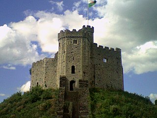
The history of Cardiff—a City and County Borough and the capital of Wales—spans at least 6,000 years. The area around Cardiff has been inhabited by modern humans since the Neolithic Period. Four Neolithic burial chambers stand within a radius of 10 mi (16 km) of Cardiff City Centre, with the St Lythans burial chamber the nearest, at about 4 mi (6.4 km) to the west. Bronze Age tumuli are at the summit of Garth Hill, within the county's northern boundary, and four Iron Age hillfort and enclosure sites have been identified within the City and County of Cardiff boundary, including Caerau Hillfort, an enclosed area of 5.1 ha. Until the Roman conquest of Britain, Cardiff was part of the territory of an Iron Age Celtic British tribe called the Silures, which included the areas that would become known as Brecknockshire, Monmouthshire and Glamorgan. The Roman fort established by the River Taff, which gave its name to the city—Caerdydd, earlier Caerdyf, from caer (fort) and Taf—was built over an extensive settlement that had been established by the Silures in the 50s AD.

<span class="mw-page-title-main">Parc le Breos</span> Medieval deer park in Wales

Parc le Breos was a great medieval deer park in the south of the Gower Peninsula, about eight miles (13 km) west of Swansea, Wales, and about 1+14 miles (2.0 km) north of the Bristol Channel. The park was an enclosed, oval area of 6.7 miles (10.8 km) in circumference, covering about 2,000 acres (810 ha) and measuring 2+12 miles (east–west) by just over 1+34 miles. Parc le Breos was established in the 1220s CE by John de Braose, Marcher Lord of Gower and husband to Margaret Ferch Llywelyn, Llywelyn Fawr's daughter. Other than for deer husbandry, the park received an income from agistment, pannage, and from sales of wild honey, ferns and dead wood. There is evidence of rabbit warrens in the park. Whether the warrens were free or domestic is unknown.

<span class="mw-page-title-main">Warren, Pembrokeshire</span> Parish in Pembrokeshire, Wales

Warren is an ancient parish in the community of Stackpole and Castlemartin, in the most southerly part of Pembrokeshire, Wales. Its northern edge is 5 miles (8 km) south of Pembroke and its southern edge reaches the sea at Flimston Bay. It is bordered by Castlemartin to the west, St Twynnells to the east and Monkton to the north.

<span class="mw-page-title-main">St Woolos Cemetery</span> Cemetery in Newport, Wales

St Woolos Cemetery is the main cemetery in the city of Newport, Wales situated one mile to the west of the Church in Wales cathedral known by the same name. It contains four chapels, and various ornate memorials dating back to the early Victorian period, and was the first municipally constructed cemetery in England and Wales. It remains in use to this present day as the main cemetery for burials in Newport, and has been used as a filming location for the BBC series, Doctor Who. The cemetery is listed on the Cadw/ICOMOS Register of Parks and Gardens of Special Historic Interest in Wales.

<span class="mw-page-title-main">Cowbridge Town Hall</span> Municipal building in Cowbridge, Wales

Cowbridge Town Hall is a public building in the High Street of Cowbridge in South Wales. The town hall, which is the meeting place for Cowbridge with Llanblethian Town Council, and also houses the town clerk's office, the committee rooms and the Cowbridge Museum, is a Grade II* listed building.

<span class="mw-page-title-main">Tiverton Cemetery</span> Cemetery in Devon, England

Tiverton Cemetery is the burial ground for the town of Tiverton in Devon. The cemetery covers eight acres and is owned and maintained by Mid Devon Council.

<span class="mw-page-title-main">St Andrew's Church, Penrice</span> Church in Swansea, Wales

The Church of St Andrew, Penrice, Swansea, Wales dates from the 12th century. A Grade II* listed building, St Andrew's remains an active parish church in the parish of South-West Gower, in the Diocese of Swansea and Brecon.

<span class="mw-page-title-main">Perth-hir House</span> House in Rockfield, Monmouthshire

Perth-hir House, Rockfield, Monmouthshire, Wales, was a major residence of the Herbert family. It stood at a bend of the River Monnow, to the north-west of the village. At its height in the 16th century, the mansion, entered by two drawbridges over a moat, comprised a great hall and a number of secondary structures. Subsequently in the ownership of the Powells, and then the Lorimers, the house became a centre of Catholic recusancy following the English Reformation. By the 19th century, the house had declined to the status of a farmhouse and it was largely demolished in around 1830. Its ruins, and the site which contains considerable remnants of a Tudor garden, are a scheduled monument.

<span class="mw-page-title-main">Registered historic parks and gardens in Merthyr Tydfil County Borough</span> List of buildings in county borough of Wales

Merthyr Tydfil County Borough is located in the historic county of Glamorgan in Wales and takes its name from its largest town. The county borough covers an area of 111 km2 (43 sq mi) and had a population of approximately 58,900 in 2021. There are three sites on the register of parks and gardens in Merthyr Tydfil County Borough. Two are listed at Grade II*, and one is Grade II.

<span class="mw-page-title-main">Registered historic parks and gardens in the Vale of Glamorgan</span> List of buildings in county borough of Wales

The Vale of Glamorgan is a county borough in south-east Wales. It covers an area of 331 km2 (128 sq mi) and in 2021 the population was approximately 132,500.

<span class="mw-page-title-main">Registered historic parks and gardens in Swansea</span> List of buildings in county of Wales

The City and County of Swansea is a principal area in south Wales. It covers an area of 380 km2 (150 sq mi) and in 2021 the population was approximately 237,800.

<span class="mw-page-title-main">Wrexham Cemetery</span> Main cemetery of Wrexham, Wales

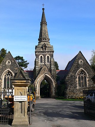
Wrexham Cemetery is a Victorian garden cemetery in Wrexham, North Wales, which served as the main burial site for the city.

References

  1. 1 2 Cadw. "Cwmgelli Cemetery (PGW(Gm)60(SWA))". National Historic Assets of Wales . Retrieved 13 June 2023.
  2. "Swansea (Cwmgelly) Cemetery". Wales at War. Retrieved 13 June 2023.
  3. "Swansea Cemeteries". The Cardiff Times . 20 October 1888. p. 4. Retrieved 21 June 2023 via The National Library of Wales.
  4. 1 2 "Swansea's new burial ground". Swansea Journal and South Wales Liberal. 28 September 1895. p. 4. Retrieved 19 June 2023 via British Newspaper Archive.
  5. "Opening of Cwmgelly Cemetery - yesterday". The Cambrian . 20 September 1895. p. 8. Retrieved 22 June 2023 via The National Library of Wales.
  6. "An attempt is being made by a small section of Swansea county councillors . . ". The Western Mail . 26 January 1892. p. 4. Retrieved 22 June 2023 via The National Library of Wales.
  7. "Cwmgelli Cemetery". Cwmgelli Cemetery. Retrieved 8 June 2023.
  8. "Cwmgelli Cemetery, Treboeth, Swansea (301667)". Coflein. RCAHMW . Retrieved 13 June 2023.
  9. "Cwmgelli Cemetery Chapel, Cwmgelli, Glandwr (13570)". Coflein. RCAHMW . Retrieved 13 June 2023.
  10. "Graves reclaimed in Merthyr Tydfil as Welsh burial space reaches 'crisis'". BBC News. 3 February 2020. Retrieved 13 June 2023.
  11. "Swansea (Cwmgelli) Cemetery". Commonwealth War Graves Commission . Retrieved 8 June 2023.
  12. Brookes, Geoff (2015). "22 January". Swansea in 100 Dates. History Press. ISBN   9780750963404.
  13. "Annual Report of the County Archivist 2012 2013". West Glamorgan Archive Service. 4 June 2013: 24. Retrieved 13 June 2023.{{cite journal}}: Cite journal requires |journal= (help)