The transport system in Rwanda centres primarily around the road network. Paved roads lie between the capital, Kigali, and most other major cities and towns in the country. Rwanda is also linked by road with other countries in the African Great Lakes, via which the majority of the country's imports and exports are made.

Kigali is the capital and largest city of Rwanda. It is near the nation's geographic centre in a region of rolling hills, with a series of valleys and ridges joined by steep slopes. As a primate city, Kigali is a relatively new city. It has been Rwanda's economic, cultural, and transport hub since it was founded as an administrative outpost in 1907, and became the capital of the country at independence in 1962, shifting focus away from Huye.

Trinity County is a county located in the northwestern portion of the U.S. state of California. Trinity County is rugged, mountainous, heavily forested, and lies along the Trinity River within the Salmon, Klamath Mountains, as well as a portion of the Scott, Trinity, and North Yolla Bolly Mountains. It is also one of three counties in California with no incorporated cities.

Bukavu is a city in eastern Democratic Republic of the Congo (DRC), lying at the extreme south-western edge of Lake Kivu, west of Cyangugu in Rwanda, and separated from it by the outlet of the Ruzizi River. It is the capital of the South Kivu Province and as of 2012 it had an estimated population of 806,940.
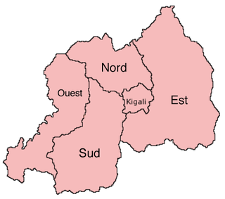
The provinces of Rwanda are divided into districts (akarere) and municipalities (umujyi). Prior to January 1, 2006, Rwanda was composed of 12 provinces. The Rwandan government decided to establish new provinces in an attempt to address issues that arose from the Rwandan genocide. The new provinces were to be "ethnically-diverse administrative areas".

Likouala is a department of the Republic of the Congo in the northern part of the country. It borders the departments of Cuvette and Sangha, and internationally, the Democratic Republic of the Congo and the Central African Republic. The region has an area of 66,044 km² and an estimated population of almost 360,000. The chief town is Impfondo. Principal cities and towns include Epena and Dongou.
Gangtok District is an administrative district of the Indian state of Sikkim. It was renamed in 2021 as a result of administrative reorganisation of the state, which also saw three subdivisions of the East Sikkim district spawned off as a separate Pakyong district.

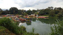
Kibuye is a city in Karongi District, and the headquarters of the Western Province in Rwanda.
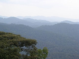
The Albertine Rift montane forests is a tropical moist broadleaf forest ecoregion in east-central Africa. The ecoregion covers the mountains of the northern Albertine Rift, and is home to distinct Afromontane forests with high biodiversity.
Tourism in Rwanda is the largest source of foreign exchange earnings in Rwanda. It was projected to grow at a rate of 25% every year from 2013–2018. The sector is the biggest contributor to the national export strategy. Total revenue generated from the sector in 2014 alone was USD 305 million.
Articles related to the Democratic Republic of the Congo include:

Kamembe International Airport,, is an airport in Rwanda. RwandAir operates a Dash 8-Q400 with seven flights per week to and from Kigali International Airport. The airport receives charter flights from Tanzania, Uganda and the Democratic Republic of the Congo, though not on a regular schedule. During the Rwandan Civil War, Kamembe airport was suggested as a site for transiting French arms to the interim government after April 1994.

Nyagatare is the largest and second most populous district (akarere) in Rwanda. Located in Eastern Province, Rwanda, it occupies the northeastern extremity of Rwanda. Its capital is Nyagatare City, the former capital of the now defunct Umutara province. Nyagatare District borders Uganda in the North, Tanzania in the East, Gatsibo District of the in the South, and Gicumbi District of the Northern Province in the West. Nyagatare has an area of 1741 km2, what makes it the largest district in Rwanda. With a population of 466,944 in 2012, and 653,861 in 2022, Nyagatare is the second most populated district of Rwanda only after Gasabo District of Kigali City with 879,505 inhabitants. This is a 156% increase from 2002 when the population was only 255,104. This sharp rise in the population is mainly due to the major movement of the population from other parts of the country in search of land.

Nyamagabe is a district (akarere) in Southern Province, Rwanda. Its capital is Gasaka.

Nyaruguru is a district (akarere) in Southern Province, Rwanda. Its capital is Kibeho, a pilgrimage site of the Catholic Church.

Rubavu District is one of the seven districts (akarere) in Western Province, Rwanda, with a total surface area of 388.4 km2. Its capital is Gisenyi, a large beach resort and border city. The Rubavu Urban area, which includes Gisenyi, Rugerero and other nearby localities, had a 2012 population of 149,209, the second most populous urban area in Rwanda.
Karongi is a district (akarere) in Western Province, Rwanda. The district's capital is Rubengera. However, it comprises Kibuye, provincial capital and a major Rwandan lakeside resort. It is one of the districts with the lowest population density of 380 inhabitants per square kilometre (980/sq mi) as of the 2022 census.

Rusizi is a district (akarere) in Western Province, Rwanda. Its capital is Cyangugu, the major city of the Rwandan south-west and the district contains large parts of the former Cyangugu Province.
Bugarama is a town in western Rwanda.