A geographic information system (GIS) consists of integrated computer hardware and software that store, manage, analyze, edit, output, and visualize geographic data. Much of this often happens within a spatial database, however, this is not essential to meet the definition of a GIS. In a broader sense, one may consider such a system also to include human users and support staff, procedures and workflows, the body of knowledge of relevant concepts and methods, and institutional organizations.
Computational archaeology describes computer-based analytical methods for the study of long-term human behaviour and behavioural evolution. As with other sub-disciplines that have prefixed 'computational' to their name, the term is reserved for methods that could not realistically be performed without the aid of a computer.
A GIS file format is a standard for encoding geographical information into a computer file, as a specialized type of file format for use in geographic information systems (GIS) and other geospatial applications. Since the 1970s, dozens of formats have been created based on various data models for various purposes. They have been created by government mapping agencies, GIS software vendors, standards bodies such as the Open Geospatial Consortium, informal user communities, and even individual developers.

Geomatics is defined in the ISO/TC 211 series of standards as the "discipline concerned with the collection, distribution, storage, analysis, processing, presentation of geographic data or geographic information". Under another definition, it consists of products, services and tools involved in the collection, integration and management of geographic (geospatial) data. It is also known as geomatic(s) engineering. Surveying engineering was the widely used name for geomatic(s) engineering in the past.

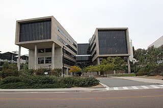
The San Diego Supercomputer Center (SDSC) is an organized research unit of the University of California, San Diego (UCSD). SDSC is located at the UCSD campus' Eleanor Roosevelt College east end, immediately north the Hopkins Parking Structure.
Geoinformatics is the science and the technology which develops and uses data, software, and computing facilities in the cyberinfrastructure ecosystem to address the needs of geosciences and related branches of science and engineering.
A GIS software program is a computer program to support the use of a geographic information system, providing the ability to create, store, manage, query, analyze, and visualize geographic data, that is, data representing phenomena for which location is important. The GIS software industry encompasses a broad range of commercial and open-source products that provide some or all of these capabilities within various information technology architectures.
Geographic information science or geoinformation science is a scientific discipline at the crossroads of computational science, social science, and natural science that studies geographic information, including how it represents phenomena in the real world, how it represents the way humans understand the world, and how it can be captured, organized, and analyzed. It is a sub-field of geography, specifically part of technical geography. It has applications to both physical geography and human geography, although its techniques can be applied to many other fields of study as well as many different industries.
United States federal research funders use the term cyberinfrastructure to describe research environments that support advanced data acquisition, data storage, data management, data integration, data mining, data visualization and other computing and information processing services distributed over the Internet beyond the scope of a single institution. In scientific usage, cyberinfrastructure is a technological and sociological solution to the problem of efficiently connecting laboratories, data, computers, and people with the goal of enabling derivation of novel scientific theories and knowledge.

Spatial analysis is any of the formal techniques which studies entities using their topological, geometric, or geographic properties. Spatial analysis includes a variety of techniques using different analytic approaches, especially spatial statistics. In may be applied in fields as diverse as astronomy, with its studies of the placement of galaxies in the cosmos, or to chip fabrication engineering, with its use of "place and route" algorithms to build complex wiring structures. In a more restricted sense, spatial analysis is geospatial analysis, the technique applied to structures at the human scale, most notably in the analysis of geographic data. It may also be applied to genomics, as in transcriptomics data.

Charlie Catlett is a senior computer scientist at Argonne National Laboratory and a visiting senior fellow at the Mansueto Institute for Urban Innovation at the University of Chicago. From 2020 to 2022 he was a senior research scientist at the University of Illinois Discovery Partners Institute. He was previously a senior computer scientist at Argonne National Laboratory and a senior fellow in the Computation Institute, a joint institute of Argonne National Laboratory and The University of Chicago, and a senior fellow at the University of Chicago's Harris School of Public Policy.
The Texas Advanced Computing Center (TACC) at the University of Texas at Austin, United States, is an advanced computing research center that is based on comprehensive advanced computing resources and supports services to researchers in Texas and across the US. The mission of TACC is to enable discoveries that advance science and society through the application of advanced computing technologies. Specializing in high performance computing, scientific visualization, data analysis & storage systems, software, research & development and portal interfaces, TACC deploys and operates advanced computational infrastructure to enable the research activities of faculty, staff, and students of UT Austin. TACC also provides consulting, technical documentation, and training to support researchers who use these resources. TACC staff members conduct research and development in applications and algorithms, computing systems design/architecture, and programming tools and environments.
Geographic information systems (GISs) have become a useful and important tool in the field of hydrology to study and manage Earth's water resources. Climate change and greater demands on water resources require a more knowledgeable disposition of arguably one of our most vital resources. Because water in its occurrence varies spatially and temporally throughout the hydrologic cycle, its study using GIS is especially practical. Whereas previous GIS systems were mostly static in their geospatial representation of hydrologic features, GIS platforms are becoming increasingly dynamic, narrowing the gap between historical data and current hydrologic reality.
Luc E. Anselin is one of the developers of the field of spatial econometrics.
Distributed GIS refers to GI Systems that do not have all of the system components in the same physical location. This could be the processing, the database, the rendering or the user interface. It represents a special case of distributed computing, with examples of distributed systems including Internet GIS, Web GIS, and Mobile GIS. Distribution of resources provides corporate and enterprise-based models for GIS. Distributed GIS permits a shared services model, including data fusion based on Open Geospatial Consortium (OGC) web services. Distributed GIS technology enables modern online mapping systems, Location-based services (LBS), web-based GIS and numerous map-enabled applications. Other applications include transportation, logistics, utilities, farm / agricultural information systems, real-time environmental information systems and the analysis of the movement of people. In terms of data, the concept has been extended to include volunteered geographical information. Distributed processing allows improvements to the performance of spatial analysis through the use of techniques such as parallel processing.

The iPlant Collaborative, renamed Cyverse in 2017, is a virtual organization created by a cooperative agreement funded by the US National Science Foundation (NSF) to create cyberinfrastructure for the plant sciences (botany). The NSF compared cyberinfrastructure to physical infrastructure, "... the distributed computer, information and communication technologies combined with the personnel and integrating components that provide a long-term platform to empower the modern scientific research endeavor". In September 2013 it was announced that the National Science Foundation had renewed iPlant's funding for a second 5-year term with an expansion of scope to all non-human life science research.
A data infrastructure is a digital infrastructure promoting data sharing and consumption.

Francine Berman is an American computer scientist, and a leader in digital data preservation and cyber-infrastructure. In 2009, she was the inaugural recipient of the IEEE/ACM-CS Ken Kennedy Award "for her influential leadership in the design, development and deployment of national-scale cyberinfrastructure, her inspiring work as a teacher and mentor, and her exemplary service to the high performance community". In 2004, Business Week called her the "reigning teraflop queen".
Science gateways provide access to advanced resources for science and engineering researchers, educators, and students. Through streamlined, online, user-friendly interfaces, gateways combine a variety of cyberinfrastructure (CI) components in support of a community-specific set of tools, applications, and data collections.: In general, these specialized, shared resources are integrated as a Web portal, mobile app, or a suite of applications. Through science gateways, broad communities of researchers can access diverse resources which can save both time and money for themselves and their institutions. As listed below, functions and resources offered by science gateways include shared equipment and instruments, computational services, advanced software applications, collaboration capabilities, data repositories, and networks.

Web GIS, or Web Geographic Information Systems, are GIS that employ the World Wide Web to facilitate the storage, visualization, analysis, and distribution of spatial information over the Internet.


