Cycleway 4

Last updated

Cycleway 4 Icon.png
Cycleway 4
Route information
NetworkCycleways
Length3.11 km
DirectionEast–West
Opened25 September 2020 (2020-09-25)
Owned by Transport for London
Southwark Council
Lewisham Council
Greenwich Council
Managed by Transport for London
Area Served City of London (Streetspace for London scheme)
Southwark
Lewisham
Greenwich
Technical
SegregationFully segregated
Track typeLong distance cycle route

Cycleway 4 is a fully segregated cycle path in London originally planned to run from Tower Bridge to Woolwich and coordinated by Transport for London. First proposed in 2008 [1] but first consulted on as Cycle Superhighway 4 between Tower Bridge and Greenwich in 2017, [2] the cycle lane has been in lengthy development. The section from Tower Bridge to Rotherhithe Roundabout, and the section on Evelyn Street and Creek Road, has been built as a permanent scheme.

Contents

In response to the COVID-19 pandemic, TfL have extended Cycleway 4 in multiple places. Temporary, lightly segregated lanes using wands have been created on London Bridge, which has also been restricted to buses and cyclists only from 7am to 7pm, Monday to Friday. [3] An extension of Cycleway 4 on Tooley Street and Duke Street Hill has been constructed to connect this to the permanent section at Tower Bridge. [4] At the other end of the planned route, a temporary extension from the Royal Naval College, Greenwich, to Angerstein Roundabout has been built using light segregation, which is being extended again to Anchor and Hope Lane.

The future permanent construction of the other segments of the cycleway depends on TfL's healthy streets budget, which has had a £300 million decrease in available money [5] due to the COVID-19 pandemic.

Construction

Cycleway 4 route is built or will be built in different stages.

London Bridge to Tower Bridge

No permanent proposals have been put forward for this section of the route; however, in Autumn 2020 lightly segregated lanes were installed over London Bridge to Duke Street Hill. [6] As part of the Streetspace for London programme, sections of lanes protected by wands and other minor improvements were installed along Tooley Street in March 2021. [7]

Tower Bridge to Rotherhithe Roundabout

This section is the first completed section of Cycleway 4 and was opened on 25 September 2020. It consists of a fully segregated bidirectional path and was built between July 2019 and September 2020, with construction interrupted between March and June 2020 due to COVID-19. The section links up with Cycleway 14 to Canada Water, and Quietway 14 (which may become Cycleway 4 [8] ), to Blackfriars Road, which further connects with Cycleway 6 on Blackfriars Road and Cycle Superhighway 7 on Southwark Bridge Road. The section will also connect with the Streetspace for London temporary cycle lane on Tooley Street.

Lower Road

This section of Cycleway 4 was not included in the original 2017 consultation, instead included in the Rotherhithe Movement Plan consultation in 2019, and is consequently further from construction. [9] Southwark council is currently reviewing the consultation with TfL. A temporary version of Cycleway 4 will be implemented in order to respond to the COVID-19 pandemic. [10] However, the construction was eventually delayed due to financial uncertainty of TfL. The construction works were started in November 2022 with the announcement from the Walking and Cycling Commissioner [11] and the section was expected to be completed in the autumn of 2023. [12]

Evelyn Street

The section was consulted on in the 2017 consultation but had not progressed to construction before the COVID-19 pandemic halted projects. [2] A temporary version of this section was announced with construction planned to start in March 2021. [13] However, this did not occur, with TfL instead announcing permanent construction of the lane beginning Summer 2021. [3] The construction was completed and opened in September 2022. [14]

Creek Road

Construction from Deptford Church Street to Norway Street in Greenwich started in November 2019 [15] but was paused from March to December 2020 due to the pandemic. Construction has now restarted and a permanent lane was completed in May 2021. [3] TfL requires additional work on the Creek Bridge in August 2021, which has caused a delay of opening for 14 weeks. [16]

Greenwich Town Centre

Initial proposals for Greenwich Town Centre have been consulted on, [17] involving converting the one way system to two way and pedestrianising College Approach and King William Walk. This would include an extension of Cycleway 4 from Norway Street to the Royal Naval College. However, no detailed proposals have been presented, and there is no available schedule for when works will start.

Royal Naval College to Anchor and Hope Lane

No permanent proposals have been presented for this section, however a temporary scheme has been implemented [18] [19] Initial ideas for the Angerstein Roundabout were included in TfL's Greenwich to Woolwich consultation in January 2020. [20]

Anchor and Hope Lane to Woolwich Ferry Roundabout

A permanent scheme was consulted on in January 2020, [20] involving a bidirectional cycle lane on the south side of the road containing safe junctions and bypassed roundabouts. The progress was paused due to TfL's financial uncertainty. In September 2023, TfL submitted a planning application with the detailed design of the cycleway to the Royal Borough of Greenwich council. [21] The planning application states that TfL is expecting to start the construction in 2025. [22]

Route

Tower Bridge to Rotherhithe

The cycle lane starts with a single-direction, eastbound track from Tooley Street before the junction with Queen Elizabeth Street, before forming a bidirectional cycle lane on the north side of the carriageway at the Tower Bridge Road junction. Heading eastbound along Tooley Street, the cycle lane reaches Tanner Street, where it connects with Quietway 14 and Cycleway 14. It continues east down Jamaica Road and bypasses the Abbey Street junction with bike pocket turnings, crosses the St James's Road crossroads and passes opposite Bermondsey tube station. It then switches to the opposite side of the road at Southwark Park Road in order to bypass the Rotherhithe Roundabout. Where it meets Lower Road, a set of traffic lights allow cyclists to continue towards Greenwich on the other side of the road until the Lower Road segment is constructed.

Royal Naval College to Angerstein Roundabout

The cycle lane begins at the Greenwich side of the naval college, before passing through the college on the main east to west shared path. This section is only open from 7am-7pm, with cyclists forced to use the unprotected Romney Road at other times. It continues as an unprotected route along Old Woolwich Road before reaching the junction with Trafalgar Road. It then forms a protected bi directional lane formed by wands. This continues on the north side of the road to the west of the Angerstein Roundabout, where it becomes shared space and crosses the middle of the roundabout using new toucan crossings. It then continues as a bidirectional lane to the Angerstein Wharf railway bridge, where it ends awaiting an extension to Charlton.

Related Research Articles

<span class="mw-page-title-main">Bermondsey</span> District in the London Borough of Southwark

Bermondsey is a district in southeast London, part of the London Borough of Southwark, England, 2.5 miles (4.0 km) southeast of Charing Cross. To the west of Bermondsey lies Southwark, to the east Rotherhithe and Deptford, to the south Walworth and Peckham, and to the north is Wapping across the River Thames. It lies within the historic county boundaries of Surrey. During the Industrial Revolution Bermondsey became a centre for manufacturing, particularly in relation to tanning. More recently it has experienced regeneration including warehouse conversions to flats and the provision of new transport links.
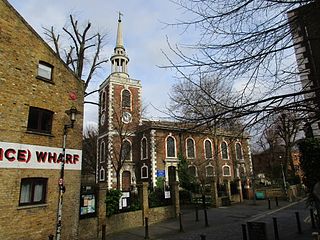
<span class="mw-page-title-main">Rotherhithe</span> Residential district in south-east London, England

Rotherhithe is a district of south-east London, England, and part of the London Borough of Southwark. It is on a peninsula on the south bank of the Thames, facing Wapping, Shadwell and Limehouse on the north bank, with the Isle of Dogs to the east. It borders Bermondsey to the west and Deptford to the south-east. The district is a part of the Docklands area.

<span class="mw-page-title-main">A3 road</span> London to Portsmouth road in England

The A3, known as the Portsmouth Road or London Road in sections, is a major road connecting the City of London and Portsmouth passing close to Kingston upon Thames, Guildford, Haslemere and Petersfield. For much of its 67-mile (108 km) length, it is classified as a trunk road and therefore managed by National Highways. Almost all of the road has been built to dual carriageway standards or wider. Apart from bypass sections in London, the road travels in a southwest direction and, after Liss, south-southwest.

<span class="mw-page-title-main">Blackwall Tunnel</span> Pair of road tunnels underneath the River Thames in London

The Blackwall Tunnel is a pair of road tunnels underneath the River Thames in east London, England, linking the London Borough of Tower Hamlets with the Royal Borough of Greenwich, and part of the A102 road. The northern portal lies just south of the East India Dock Road (A13) in Blackwall; the southern entrances are just south of The O2 on the Greenwich Peninsula. The road is managed by Transport for London (TfL).

<span class="mw-page-title-main">Rotherhithe Tunnel</span> Road tunnel under the Thames river

The Rotherhithe Tunnel, designated the A101, is a road tunnel under the River Thames in East London, connecting Limehouse in the London Borough of Tower Hamlets north of the river to Rotherhithe in the London Borough of Southwark south of the river. It was formally opened in 1908 by George, Prince of Wales, and Richard Robinson, Chairman of the London County Council. It is a rare example of a road tunnel where road traffic, pedestrians and cyclists all share the same tunnel bore. Transport for London took over ownership and maintenance of the tunnel in 2001.

<span class="mw-page-title-main">A13 road (England)</span> Major road in England

The A13 is a major road in England linking Central London with east London and south Essex. Its route is similar to that of the London, Tilbury and Southend line via Rainham, Grays, Tilbury, Stanford-Le-Hope & Pitsea,and runs the entire length of the northern Thames Gateway area, terminating on the Thames Estuary at Shoeburyness. It is a trunk road between London and the Tilbury junction, a primary route between there and Sadlers Hall Farm near South Benfleet, and a non-primary route between there and Shoeburyness.

<span class="mw-page-title-main">Thames Gateway Bridge</span>

The Thames Gateway Bridge was a proposed crossing over the River Thames in east London, England. It was first mooted in the 1970s but never came to fruition. The concept was re-proposed in 2004, with preliminary planning proceeding until November 2008, when Boris Johnson, the then Mayor of London, formally cancelled the entire £500 million scheme.

<span class="mw-page-title-main">South East London Green Chain</span>

The South East London Green Chain, also known as the Green Chain Walk, is a linked system of open spaces between the River Thames and Crystal Palace Park in London, England. In 1977 four London boroughs and the Greater London Council created this Green Chain of 300 open spaces to protect them from building activity. The four London boroughs are Bexley, Bromley, Lewisham and Greenwich. More recently it has been extended to include sections in Southwark. Many parts of the system are also part of the Capital Ring route.

<span class="mw-page-title-main">Silvertown Tunnel</span> Tunnel under construction below the Thames between Sivertown and North Greenwich

The Silvertown Tunnel is a road tunnel under construction beneath the River Thames between the Greenwich Peninsula and west Silvertown.

<span class="mw-page-title-main">A201 road</span> Road in Central London

The A201 is an A road in London, England running from Kings Cross to Bricklayer's Arms.

<span class="mw-page-title-main">A202 road</span> Primary A road in London, England

The A202 is a primary A road in London. It runs from New Cross Gate to London Victoria station. A section of the route forms a part of the London Inner Ring Road between Vauxhall and Victoria, known as Vauxhall Bridge Road.

<span class="mw-page-title-main">A200 road</span> Road in London, England

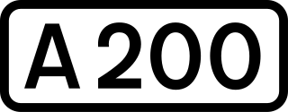
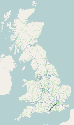
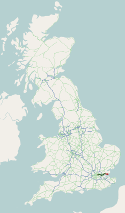
The A200 is an A road in London running from London Bridge to Greenwich.

<span class="mw-page-title-main">Bakerloo line extension</span> Proposed southern extension of the London Underground

The Bakerloo line extension is a proposed extension of the London Underground Bakerloo line in South London from its current terminus at Elephant & Castle to Lewisham station.

<span class="mw-page-title-main">Gallions Reach Crossing</span> Proposed bridge or ferry crossing the River Thames

The Gallions Reach Crossing was a proposed River Thames crossing close to Gallions Reach in East London, running between Beckton in the London Borough of Newham and Thamesmead in the Royal Borough of Greenwich. Originally a proposed ferry crossing replacing the Woolwich Ferry, later plans suggested either a bridge or a tunnel.

<span class="mw-page-title-main">Cycleway 3</span> Long cycle path in London, England

Cycleway 3 (C3) is a cycle route in London, England. It is part of the Cycleway network coordinated by TfL. It runs from Barking in the east to Lancaster Gate in central London. It is a popular route with both commuter and leisure cyclists, passing a number of major destinations in London along its route. For almost the entire route, cyclists are separated from other traffic in segregated cycle lanes, and cycling infrastructure has been provided at major interchanges. The cycleway, originally called Cycle Superhighway 3, was renamed to Cycleway 3 in January 2023.

The Docklands Light Railway extension to Thamesmead is a proposed Docklands Light Railway (DLR) extension to serve the Beckton Riverside and Thamesmead redevelopment areas of East London.

<span class="mw-page-title-main">Rotherhithe crossing</span> Proposed route across the River Thames in London, England

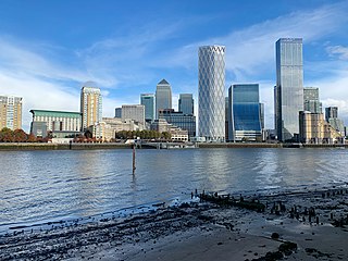
The Rotherhithe crossing is a proposed route for pedestrians and cyclists across the River Thames in London, England between Rotherhithe and Canary Wharf.

<span class="mw-page-title-main">Old Oak Common Lane railway station</span> Proposed railway station in London, England

Old Oak Common Lane railway station is a proposed railway station in West London, UK. If constructed, it will be situated on the North London Line, between Acton Central and Willesden Junction, within the London Overground commuter rail system. Old Oak Common Lane station would be situated about 400 yards to the west of the planned Old Oak Common railway station and will offer interchange between London Overground and other rail services, including National Rail, Crossrail and High Speed 2. It is one of two proposed new stations which will connect with Old Oak Common, the other being Hythe Road on the West London line.

References

  1. "Mayor announces first two Cycle Superhighway routes". road.cc. 8 June 2009. Retrieved 5 April 2021.
  2. 1 2 "Have your say on Cycle Superhighway Route 4 from Tower Bridge to Greenwich - Transport for London - Citizen Space". consultations.tfl.gov.uk. Retrieved 18 February 2021.
  3. 1 2 3 "Cycleway 4 - Transport for London". Archived from the original on 15 April 2018.
  4. "Tooley Street and Duke Street Hill - Transport for London - Citizen Space". consultations.tfl.gov.uk. Retrieved 18 February 2021.
  5. "News from Caroline Russell: Mayor's Streetspace plan 'sticking plaster' covering £300m cuts". London City Hall. 18 June 2020. Retrieved 5 April 2021.
  6. "London Bridge corridor - Transport for London - Citizen Space". consultations.tfl.gov.uk. Retrieved 5 April 2021.
  7. "Tooley Street and Duke Street Hill - Transport for London - Citizen Space". consultations.tfl.gov.uk. Retrieved 5 April 2021.
  8. "Cycle". Transport for London. Retrieved 5 April 2021.
  9. "Rotherhithe Movement Plan - Lower Road Two-Way streets and Cycleway 4 - London Borough of Southwark - Citizen Space". consultations.southwark.gov.uk. Retrieved 18 February 2021.
  10. "Issue details - Covid-19 – Post lockdown highway schemes Batch 4". Southwark Council. 29 September 2020. Retrieved 18 February 2021.
  11. "Work is well underway on the new section of Cycleway 4 - filling the gap on the route between Tower Bridge and Greenwich". X (formerly Twitter). Retrieved 1 September 2023.
  12. Matters, Transport for London | Every Journey. "Cycleway 4". Transport for London. Retrieved 1 September 2023.
  13. Raha, Alex. "Cycleway 4 – work in progress – Lewisham Cyclists" . Retrieved 18 February 2021.
  14. "TfL Press Release - New section of cycle route opens in Deptford, as part of Cycleway 4 in southeast London". tfl-newsroom.prgloo.com. Retrieved 1 September 2023.
  15. "Construction work on new London cycleway reaches major milestone". Infrastructure Intelligence. Retrieved 18 February 2021.
  16. "Deptford's new Cycleway 4 to stay closed for months because of bridge works". 853. 20 August 2021. Retrieved 28 August 2021.
  17. "1. Ideas for a better Greenwich town centre". greenwichtowncentreproposals.commonplace.is. Retrieved 5 April 2021.
  18. "Improvements for pedestrians, cyclists and bus passengers between Greenwich and Woolwich Phase 1: Park Row to Angerstein Roundabout - Transport for London - Citizen Space". consultations.tfl.gov.uk. Retrieved 5 April 2021.
  19. "Improvements for pedestrians, cyclists and bus passengers between Greenwich and Woolwich Phase 1b: Woolwich Road from Aldeburgh Street to Anchor and Hope Lane - Transport for London - Citizen Space". consultations.tfl.gov.uk. Retrieved 5 April 2021.
  20. 1 2 "We want your views on the first phase of our proposals to transform streets in south-east London between Greenwich and Woolwich - Transport for London - Citizen Space". consultations.tfl.gov.uk. Retrieved 5 April 2021.
  21. Smith, John (25 September 2023). "Major street changes as Cycleway 4 extension submitted through Greenwich borough". Murky Depths. Retrieved 28 September 2023.
  22. "23/3099/TC | Removal of trees as per plan and covering letter to enable highway improvements and replace with suitable specimens once works completed | STREET RECORD, FOOTPATH FROM WOOLWICH ROAD TO EASTMOOR PLACE, CHARLTON". planning.royalgreenwich.gov.uk. Retrieved 28 September 2023.