
The Rurubu River is a river in central Africa whose waters gather from the most distant portion of the Nile basin. It is about 300 km long. It rises in the north of Burundi, near the town of Kayanza and then does a southward arc through Burundi, being joined by the Ruvyironza River near Gitega. From there it runs northeast, through the Ruvubu National Park, up to the Tanzanian border. After a stretch along the border, the Ruvubu crosses properly into Tanzania, before joining the Nyabarongo River on the Tanzania–Rwanda border near Rusumo Falls, to form the Kagera River.
Kępy is a village in the administrative district of Gmina Wądroże Wielkie, within Jawor County, Lower Silesian Voivodeship, in south-western Poland. Prior to 1945 it was in Germany.
Sośno is a village in Sępólno County, Kuyavian-Pomeranian Voivodeship, in north-central Poland. It is the seat of the gmina called Gmina Sośno. It lies approximately 13 kilometres (8 mi) south-east of Sępólno Krajeńskie and 37 km (23 mi) north-west of Bydgoszcz.

Dąb Polski is a village in the administrative district of Gmina Włocławek, within Włocławek County, Kuyavian-Pomeranian Voivodeship, in north-central Poland. It lies approximately 24 kilometres (15 mi) east of Włocławek and 71 km (44 mi) south-east of Toruń.
Rybaki is a village in the administrative district of Gmina Michałowo, within Białystok County, Podlaskie Voivodeship, in north-eastern Poland, close to the border with Belarus.
Wilcza Jama is a village in the administrative district of Gmina Sokółka, within Sokółka County, Podlaskie Voivodeship, in north-eastern Poland, close to the border with Belarus.
Kwasówka is a settlement in the administrative district of Gmina Janów, within Sokółka County, Podlaskie Voivodeship, in north-eastern Poland. It lies approximately 9 kilometres (6 mi) south of Janów, 18 km (11 mi) west of Sokółka, and 31 km (19 mi) north of the regional capital Białystok.
Oprzężów-Kolonia is a village in the administrative district of Gmina Wola Krzysztoporska, within Piotrków County, Łódź Voivodeship, in central Poland.
Broszki-Kolonia is a village in the administrative district of Gmina Złoczew, within Sieradz County, Łódź Voivodeship, in central Poland. It lies approximately 5 kilometres (3 mi) south-east of Złoczew, 25 km (16 mi) south of Sieradz, and 72 km (45 mi) south-west of the regional capital Łódź.
Grądy is a village in the administrative district of Gmina Galewice, within Wieruszów County, Łódź Voivodeship, in central Poland. It lies approximately 6 kilometres (4 mi) north-west of Galewice, 11 km (7 mi) north-east of Wieruszów, and 98 km (61 mi) south-west of the regional capital Łódź.
Niemojew is a village in the administrative district of Gmina Lututów, within Wieruszów County, Łódź Voivodeship, in central Poland. It lies approximately 3 kilometres (2 mi) north-east of Lututów, 24 km (15 mi) north-east of Wieruszów, and 83 km (52 mi) south-west of the regional capital Łódź.
Graby is a village in the administrative district of Gmina Złota, within Pińczów County, Świętokrzyskie Voivodeship, in south-central Poland.
Dąbie is a village in the administrative district of Gmina Secemin, within Włoszczowa County, Świętokrzyskie Voivodeship, in south-central Poland. It lies approximately 7 kilometres (4 mi) south-west of Secemin, 20 km (12 mi) south-west of Włoszczowa, and 63 km (39 mi) west of the regional capital Kielce.
Secymin Polski is a village in the administrative district of Gmina Leoncin, within Nowy Dwór Mazowiecki County, Masovian Voivodeship, in east-central Poland. It lies approximately 18 kilometres (11 mi) west of Nowy Dwór Mazowiecki and 43 km (27 mi) north-west of Warsaw.
Kazuń Polski is a village in the administrative district of Gmina Czosnów, within Nowy Dwór Mazowiecki County, Masovian Voivodeship, in east-central Poland. It lies approximately 6 kilometres (4 mi) west of Czosnów, 4 km (2 mi) south of Nowy Dwór Mazowiecki, and 31 km (19 mi) north-west of Warsaw.
Skały is a village in the administrative district of Gmina Toszek, within Gliwice County, Silesian Voivodeship, in southern Poland. It lies approximately 10 kilometres (6 mi) west of Toszek, 30 km (19 mi) north-west of Gliwice, and 51 km (32 mi) north-west of the regional capital Katowice.
Jabłonka is a settlement in the administrative district of Gmina Trzciel, within Międzyrzecz County, Lubusz Voivodeship, in western Poland. It lies approximately 3 kilometres (2 mi) north of Trzciel, 21 km (13 mi) east of Międzyrzecz, 57 km (35 mi) north-east of Zielona Góra, and 58 km (36 mi) south-east of Gorzów Wielkopolski.
Przodkowo-Wybudowanie is a village in the administrative district of Gmina Przodkowo, within Kartuzy County, Pomeranian Voivodeship, in northern Poland. It lies approximately 2 kilometres (1 mi) north of Przodkowo, 9 km (6 mi) north-east of Kartuzy, and 23 km (14 mi) west of the regional capital Gdańsk.
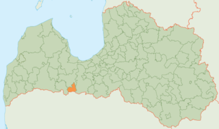
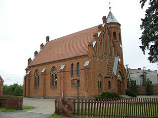
Tērvete Municipality is a municipality in Zemgale, Latvia. The municipality was formed in 2002 by merging Augstkalne parish, Bukaiši parish and Tērvete parish, the administrative centre being Zelmeņi.
The Atlanta Hotel also known as Thompson's Hotel, was one of the original hotels in antebellum Atlanta, Georgia. It stood at the northwest side of State Square, pre-war Atlanta's central square, on the northwest side of Pryor Street between Decatur Street and what is now Wall Street.


