
San Pedro District is one of twenty-one districts of the province Lucanas in Peru.
Santa Lucía District is one of twenty-one districts of the province Lucanas in Peru.

Budziarze is a village in the administrative district of Gmina Biszcza, within Biłgoraj County, Lublin Voivodeship, in eastern Poland. It lies approximately 6 kilometres (4 mi) north of Biszcza, 12 km (7 mi) south-west of Biłgoraj, and 88 km (55 mi) south of the regional capital Lublin.
Karoliny is a village in the administrative district of Gmina Sztabin, within Augustów County, Podlaskie Voivodeship, in north-eastern Poland. It lies approximately 5 kilometres (3 mi) west of Sztabin, 19 km (12 mi) south of Augustów, and 65 km (40 mi) north of the regional capital Białystok.

Sahqaya is a village in Baku, Azerbaijan.
Məmər, transliterated alternatively as Memer, is a village in the Qubadli Rayon of Azerbaijan.
Maçkalaşen is a village in the Martuni Province of the de facto Republic of Artsakh, de jure part of the Republic of Azerbaijan.
Mayıs is a village in the Lachin Rayon of Azerbaijan.
Jeziorko is a village in the administrative district of Gmina Mokrsko, within Wieluń County, Łódź Voivodeship, in central Poland. It lies approximately 3 kilometres (2 mi) south of Mokrsko, 11 km (7 mi) south-west of Wieluń, and 99 km (62 mi) south-west of the regional capital Łódź.
Janówka is a village in the administrative district of Gmina Hanna, within Włodawa County, Lublin Voivodeship, in eastern Poland, close to the border with Belarus.
Błoniec is a village in the administrative district of Gmina Busko-Zdrój, within Busko County, Świętokrzyskie Voivodeship, in south-central Poland.
Drzenkowice is a village in the administrative district of Gmina Ćmielów, within Ostrowiec County, Świętokrzyskie Voivodeship, in south-central Poland. It lies approximately 5 kilometres (3 mi) south-west of Ćmielów, 9 km (6 mi) south-east of Ostrowiec Świętokrzyski, and 60 km (37 mi) east of the regional capital Kielce.
Kołków is a village in the administrative district of Gmina Michałów, within Pińczów County, Świętokrzyskie Voivodeship, in south-central Poland. It lies approximately 4 kilometres (2 mi) south of Michałów, 11 km (7 mi) south-west of Pińczów, and 49 km (30 mi) south of the regional capital Kielce.
Płaczkowice is a village in the administrative district of Gmina Klimontów, within Sandomierz County, Świętokrzyskie Voivodeship, in south-central Poland. It lies approximately 6 kilometres (4 mi) north-west of Klimontów, 25 km (16 mi) west of Sandomierz, and 60 km (37 mi) east of the regional capital Kielce.
Wygiełzów is a village in the administrative district of Gmina Irządze, within Zawiercie County, Silesian Voivodeship, in southern Poland. It lies approximately 2 kilometres (1 mi) north of Irządze, 26 km (16 mi) north-east of Zawiercie, and 66 km (41 mi) north-east of the regional capital Katowice.
Chróścina is a village in the administrative district of Gmina Lewin Brzeski, within Brzeg County, Opole Voivodeship, in south-western Poland. It lies approximately 6 kilometres (4 mi) east of Lewin Brzeski, 19 km (12 mi) south-east of Brzeg, and 20 km (12 mi) north-west of the regional capital Opole.
Magnuszowiczki is a village in the administrative district of Gmina Niemodlin, within Opole County, Opole Voivodeship, in south-western Poland.
Pęklewo is a settlement in the administrative district of Gmina Tolkmicko, within Elbląg County, Warmian-Masurian Voivodeship, in northern Poland. It lies approximately 6 kilometres (4 mi) south-west of Tolkmicko, 23 km (14 mi) north of Elbląg, and 89 km (55 mi) north-west of the regional capital Olsztyn.
Fenghua railway station is a railway station of Yongtaiwen Railway located in Zhejiang, People's Republic of China.
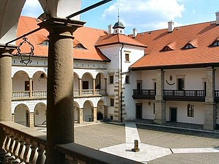
The Niepołomice Royal Castle is a Gothic castle from the mid-14th century, rebuilt in the late Renaissance style and called the second Wawel. It is situated in Niepołomice, Poland.


