
The siege of Warsaw in 1939 was fought between the Polish Warsaw Army garrisoned and entrenched in Warsaw and the invading German Army.
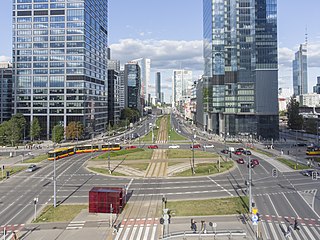
Wola is a district in western Warsaw, Poland. An industrial area with traditions reaching back to the early 19th century, it underwent a transformation into a major financial district, featuring various landmarks and some of the tallest office buildings in the city.
Kabaty is a residential neighborhood in Ursynów, the southernmost district of Warsaw. Sparsely populated until the late 1980s, Kabaty witnessed rapid growth in the 1990s and especially the 2000s. It is located near the Kabaty Woods, a popular weekend destination for Warsaw citizens.

Jerusalem Avenue is one of the principal streets of the capital city of Warsaw in Poland. It runs through the City Centre along the East-West axis, linking the western borough of Wola with the bridge on the Vistula River and the borough of Praga on the other side of the river.

The battle of Warsaw, also known as the battle and storming of Warsaw, was fought in September 1831 between Imperial Russia and Poland. After a two-day assault on the city's western fortifications, the Polish defences collapsed and the city was evacuated. It was the largest battle and the final episode of the Polish–Russian War of 1830–31, a conflict that became better known as the November Uprising.

The Wola massacre was the systematic killing of between 40,000 and 50,000 Poles in the Wola neighbourhood of the Polish capital city, Warsaw, by the Waffen-SS and fellow Axis collaborators in the Azerbaijani Legion, as well as the mostly-Russian RONA forces, which took place from 5 to 12 August 1944. The massacre was ordered by Heinrich Himmler, who directed to kill "anything that moves" to stop the Warsaw Uprising soon after it began.

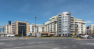
Ochota is a district of Warsaw, Poland, located in the central part of the city's urban agglomeration. It is Warsaw's most densely populated district and home to the scientific campus of the University of Warsaw.

Włochy is one of the districts of Warsaw, located in the south-western part of city. Włochy borders districts Bemowo and Wola from the north, Ochota and Mokotów from the east, and Ursus and Ursynów from the south.

Wesoła is one of the districts of Warsaw, and has been as such since October 27, 2002. Wesoła is located in the south-eastern part of city.

The Ochota Massacre was a wave of German-orchestrated mass murder, looting, arson, torture and rape, which swept through the Warsaw district of Ochota from 4–25 August 1944, during the Warsaw Uprising. The principal perpetrators of these war crimes were the Nazi collaborationist S.S. Sturmbrigade R.O.N.A., the so-called "Russian National Liberation Army", commanded by Bronislav Kaminski.

The Warsaw Insurgents Cemetery is located at 174/176 Wolska Street in the Wola district of Warsaw. It was established in 1945 and occupies 1.5 hectares.
The Battle of Pęcice took place on 2 August 1944 between military units of Armia Krajowa, belonging to the 4th Ochota Sub-district, and the German military during the Warsaw Uprising in Poland during World War II.

Narutowicz Square is a city square located in the Ochota district in Warsaw, Poland.

Wolska is the main artery of Warsaw's borough of Wola. Initially Wola district was but a western suburb of Warsaw and a road leading to it was dubbed "droga wolska" - Wola road. In 1725 parts of that road closest to the Warsaw Old Town, located along the Saxon Axis, were officially renamed to "Aleja Wolska" - Wola Avenue. In modern times it starts at a crossing of Chłodna and Towarowa Streets, and runs as a continuation of Solidarity Avenue through the neighbourhoods of Młynów, Czyste and Ulrychów, all the way to Połczyńska Street.

Artur Zawisza Square is a public square in Warsaw's borough of Ochota. It is named after Artur Zawisza, a 19th-century Polish revolutionary who was executed on the spot by Russians in 1833.

The Wola Massacre Memorial on Górczewska Street is a war memorial located at 32 Górczewska Street in the Wola district of Warsaw, Poland.

The Warsaw Icon Museum is the first museum in Warsaw and the third in Poland dedicated to icons. Located in the Ochota district of Warsaw, Poland, the museum is housed in a former boilerhouse.

Henryków is a neighborhood of the Białołęka district of northern Warsaw, Poland. The estate is located east of Modlińska Street.

Ujazdów is a prominent neighbourhood situated in central Warsaw, the capital of Poland. It is the southernmost part of the Downtown (Śródmieście) district, next to Solec and historical Frascati. The main thoroughfare passing through the neighbourhood is Ujazdów Avenue; the Chancellery of the Prime Minister of Poland, the Foreign Ministry and the Belweder Palace are located on or in the vicinity of the street. Ujazdów is an affluent neighbourhood, with villas, palaces and parks comprising most of its area. The most notable landmarks are the Łazienki Park and Palace on the Isle, the 18th century summer residence of Poland's last monarch Stanisław II Augustus.

Odolany is a neighbourhood, and an area of the City Information System, in the city of Warsaw, Poland, located within the district of Wola.
