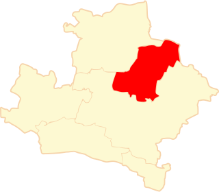
Rudna is a village in Lubin County, Lower Silesian Voivodeship, in south-western Poland. It is the seat of the administrative district (gmina) called Gmina Rudna. Prior to 1945 it was in Germany. It lies approximately 14 kilometres (9 mi) north of Lubin and 69 km (43 mi) north-west of the regional capital Wrocław.

Konstantyna is a village in the administrative district of Gmina Rzgów, within Łódź East County, Łódź Voivodeship, in central Poland. It lies approximately 5 kilometres (3 mi) north-east of Rzgów and 11 km (7 mi) south of the regional capital Łódź.
Woźniki is a village in the administrative district of Gmina Zapolice, within Zduńska Wola County, Łódź Voivodeship, in central Poland. It lies approximately 4 kilometres (2 mi) south of Zapolice, 12 km (7 mi) south-west of Zduńska Wola, and 51 km (32 mi) south-west of the regional capital Łódź.
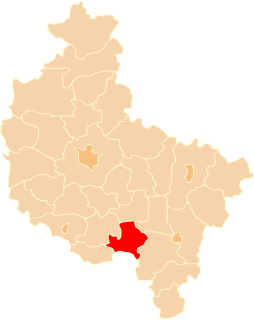
Biadoliny Szlacheckie is a village in the administrative district of Gmina Dębno, within Brzesko County, Lesser Poland Voivodeship, in southern Poland.
Wola Zadybska-Kolonia is a village in the administrative district of Gmina Kłoczew, within Ryki County, Lublin Voivodeship, in eastern Poland. It lies approximately 14 kilometres (9 mi) north of Ryki and 74 km (46 mi) north-west of the regional capital Lublin.
Krzczonowice is a village in the administrative district of Gmina Staszów, within Staszów County, Świętokrzyskie Voivodeship, in south-central Poland. It lies approximately 8 kilometres (5 mi) south-west of Staszów and 54 km (34 mi) south-east of the regional capital Kielce.
Oskardów is a settlement in the administrative district of Gmina Warka, within Grójec County, Masovian Voivodeship, in east-central Poland.
Czerwonka is a village in the administrative district of Gmina Grabów nad Pilicą, within Kozienice County, Masovian Voivodeship, in east-central Poland. It lies approximately 3 kilometres (2 mi) north-west of Grabów nad Pilicą, 32 km (20 mi) north-west of Kozienice, and 54 km (34 mi) south of Warsaw.
Baranów is a village in the administrative district of Gmina Chotcza, within Lipsko County, Masovian Voivodeship, in east-central Poland. It lies approximately 4 kilometres (2 mi) south-west of Chotcza, 10 km (6 mi) north-east of Lipsko, and 123 km (76 mi) south-east of Warsaw.
Białe-Figle is a village in the administrative district of Gmina Boguty-Pianki, within Ostrów Mazowiecka County, Masovian Voivodeship, in east-central Poland.
Nagoszewo is a village in the administrative district of Gmina Ostrów Mazowiecka, within Ostrów Mazowiecka County, Masovian Voivodeship, in east-central Poland. It lies approximately 9 kilometres (6 mi) south-west of Ostrów Mazowiecka and 81 km (50 mi) north-east of Warsaw.
Wymysłów is a settlement in the administrative district of Gmina Potworów, within Przysucha County, Masovian Voivodeship, in east-central Poland.
Chrzczanka Włościańska is a village in the administrative district of Gmina Długosiodło, within Wyszków County, Masovian Voivodeship, in east-central Poland.
Choszczowe is a village in the administrative district of Gmina Zabrodzie, within Wyszków County, Masovian Voivodeship, in east-central Poland.
Gołąbki is a village in the administrative district of Gmina Trzemeszno, within Gniezno County, Greater Poland Voivodeship, in west-central Poland. It lies approximately 10 kilometres (6 mi) north-west of Trzemeszno, 16 km (10 mi) north-east of Gniezno, and 63 km (39 mi) north-east of the regional capital Poznań.
Biele is a village in the administrative district of Gmina Sompolno, within Konin County, Greater Poland Voivodeship, in west-central Poland.
Grabów-Pustkowie is a village in the administrative district of Gmina Grabów nad Prosną, within Ostrzeszów County, Greater Poland Voivodeship, in west-central Poland. It lies approximately 3 kilometres (2 mi) north-west of Grabów nad Prosną, 14 km (9 mi) north-east of Ostrzeszów, and 127 km (79 mi) south-east of the regional capital Poznań.
Płytnica is a settlement in the administrative district of Gmina Szydłowo, within Piła County, Greater Poland Voivodeship, in west-central Poland. It lies approximately 18 kilometres (11 mi) north-east of Szydłowo, 17 km (11 mi) north of Piła, and 100 km (62 mi) north of the regional capital Poznań.
Piekarniak is a settlement in the administrative district of Gmina Kwidzyn, within Kwidzyn County, Pomeranian Voivodeship, in northern Poland. It lies approximately 3 kilometres (2 mi) north-east of Kwidzyn and 72 km (45 mi) south of the regional capital Gdańsk.
Dolny Siniec is a village in the administrative district of Gmina Srokowo, within Kętrzyn County, Warmian-Masurian Voivodeship, in northern Poland, close to the border with the Kaliningrad Oblast of Russia.