Laakso is a neighbourhood in Helsinki, Finland. Its borders are defined by the streets of Mannerheimintie and Nordenskiöldinkatu and the Helsinki Central Park. The neighbourhood is bordered by Töölö in the south, Meilahti in the southwest, Ruskeasuo in the north and Länsi-Pasila in the east.

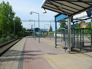
Tapanila (Finnish) or Mosabacka (Swedish) is a railway station in the Tapanila district of Helsinki, Finland. It is located between the stations of Malmi and Puistola, along the main railroad track from Helsinki to Riihimäki, about 13 kilometres northeast from the Helsinki Central railway station.

Wilkszyn is a village in the administrative district of Gmina Miękinia, within Środa Śląska County, Lower Silesian Voivodeship, in south-western Poland. Prior to 1945 it was in Germany.

Byków is a village in the administrative district of Gmina Długołęka, within Wrocław County, Lower Silesian Voivodeship, in south-western Poland. Prior to 1945 it was in de:Landkreis Oels, in the Breslau district of (Silesia) Germany.

Międzyrzecze is a village in the administrative district of Gmina Supraśl, within Białystok County, Podlaskie Voivodeship, in north-eastern Poland. It lies approximately 10 kilometres (6 mi) north-east of Supraśl and 26 km (16 mi) north-east of the regional capital Białystok.

Mikołajewice-Kolonia is a village in the administrative district of Gmina Lutomiersk, within Pabianice County, Łódź Voivodeship, in central Poland. It lies approximately 2 kilometres (1 mi) south of Lutomiersk, 17 km (11 mi) north-west of Pabianice, and 20 km (12 mi) west of the regional capital Łódź.
Nowy Gaj is a village in the administrative district of Gmina Wojciechów, within Lublin County, Lublin Voivodeship, in eastern Poland.

Przybyszowy is a village in the administrative district of Gmina Końskie, within Końskie County, Świętokrzyskie Voivodeship, in south-central Poland. It lies approximately 10 kilometres (6 mi) west of Końskie and 42 km (26 mi) north-west of the regional capital Kielce.

Pakosław is a village in the administrative district of Gmina Iłża, within Radom County, Masovian Voivodeship, in east-central Poland. It lies approximately 6 kilometres (4 mi) north-west of Iłża, 24 km (15 mi) south of Radom, and 115 km (71 mi) south of Warsaw.
Topórek is a village in the administrative district of Gmina Siedlce, within Siedlce County, Masovian Voivodeship, in east-central Poland.

Jelenie is a village in the administrative district of Gmina Kraszewice, within Ostrzeszów County, Greater Poland Voivodeship, in west-central Poland. It lies approximately 21 kilometres (13 mi) north-east of Ostrzeszów and 138 km (86 mi) south-east of the regional capital Poznań.

Częstocin is a village in the administrative district of Gmina Przywidz, within Gdańsk County, Pomeranian Voivodeship, in northern Poland. It lies approximately 6 kilometres (4 mi) west of Przywidz, 27 km (17 mi) west of Pruszcz Gdański, and 33 km (21 mi) south-west of the regional capital Gdańsk.

Nowy Dwór is a settlement in the administrative district of Gmina Somonino, within Kartuzy County, Pomeranian Voivodeship, in northern Poland. It lies approximately 4 kilometres (2 mi) south-east of Somonino, 9 km (6 mi) south of Kartuzy, and 29 km (18 mi) south-west of the regional capital Gdańsk.

Troszki is a village in the administrative district of Gmina Dębnica Kaszubska, within Słupsk County, Pomeranian Voivodeship, in northern Poland. It lies approximately 7 kilometres (4 mi) east of Dębnica Kaszubska, 18 km (11 mi) south-east of Słupsk, and 89 km (55 mi) west of the regional capital Gdańsk.

Zdrójno is a village in the administrative district of Gmina Osieczna, within Starogard County, Pomeranian Voivodeship, in northern Poland. It lies approximately 5 kilometres (3 mi) south-east of Osieczna, 30 km (19 mi) south-west of Starogard Gdański, and 73 km (45 mi) south of the regional capital Gdańsk.

Borowo is a settlement in the administrative district of Gmina Wejherowo, within Wejherowo County, Pomeranian Voivodeship, in northern Poland. It lies approximately 7 kilometres (4 mi) south of Wejherowo and 31 km (19 mi) north-west of the regional capital Gdańsk.

Pasławki is a village in the administrative district of Gmina Sępopol, within Bartoszyce County, Warmian-Masurian Voivodeship, in northern Poland, close to the border with the Kaliningrad Oblast of Russia. It lies approximately 9 kilometres (6 mi) south of Sępopol, 16 km (10 mi) south-east of Bartoszyce, and 57 km (35 mi) north-east of the regional capital Olsztyn.

Borzym is a village in the administrative district of Gmina Gryfino, within Gryfino County, West Pomeranian Voivodeship, in north-western Poland, close to the German border. It lies approximately 12 kilometres (7 mi) south-east of Gryfino and 26 km (16 mi) south of the regional capital Szczecin.

Strzaliny is a village in the administrative district of Gmina Tuczno, within Wałcz County, West Pomeranian Voivodeship, in north-western Poland. It lies approximately 2 kilometres (1 mi) north-east of Tuczno, 23 km (14 mi) west of Wałcz, and 108 km (67 mi) east of the regional capital Szczecin.
Dương Đức is a commune (xã) and village in Lạng Giang District, Bắc Giang Province, in northeastern Vietnam.


