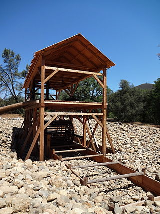
Sutter's Mill was a water-powered sawmill on the bank of the South Fork American River in the foothills of the Sierra Nevada in California. It was named after its owner John Sutter. A worker constructing the mill, James W. Marshall, found gold there in 1848. This discovery set off the California Gold Rush (1848–1855), a major event in the history of the United States.

Sutter's Fort was a 19th-century agricultural and trade colony in the Mexican Alta California province. Established in 1839, the site of the fort was originally called New Helvetia by its builder John Sutter, though construction of the fort proper would not begin until 1841. The fort was the first non-indigenous community in the California Central Valley. The fort is famous for its association with the Donner Party, the California Gold Rush, and the formation of the city of Sacramento, surrounding the fort. It is notable for its proximity to the end of the California Trail and Siskiyou Trails, which it served as a waystation.

Bodie is a ghost town in the Bodie Hills east of the Sierra Nevada mountain range in Mono County, California, United States. It is about 75 miles (121 km) southeast of Lake Tahoe, and 12 mi (19 km) east-southeast of Bridgeport, at an elevation of 8,379 feet (2554 m). Bodie became a boom town in 1876 after the discovery of a profitable vein of gold; by 1879 it had established 2,000 structures with a population of roughly 8,000 people.
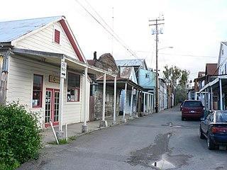
Locke, also known as Locke Historic District, is an unincorporated community in the Sacramento–San Joaquin River Delta of California, United States. The 14-acre town (5.7 ha) was first developed between 1893 and 1915 approximately one mile north of the town of Walnut Grove in Sacramento County.

Old Sacramento State Historic Park occupies around one third of the property within the Old Sacramento Historic District of Sacramento, California. The Old Sacramento Historic District is a U.S. National Historic Landmark District. The Historic District is sometimes abbreviated as Old Sacramento, or Old Sac, and since the 1960s has been restored and developed as a significant tourist attraction.
The Bank of California was opened in San Francisco, California, on July 4, 1864, by William Chapman Ralston and Darius Ogden Mills. It was the first commercial bank in the Western United States, and considered instrumental in developing the American Old West.

Darius Ogden Mills was a prominent American banker and philanthropist. For a time, he was California's wealthiest citizen.

Empire Mine State Historic Park is a state-protected mine and park in the Sierra Nevada mountains in Grass Valley, California, U.S. The Empire Mine is on the National Register of Historic Places, a federal Historic District, and a California Historical Landmark. Since 1975 California State Parks has administered and maintained the mine as a historic site. The Empire Mine is "one of the oldest, largest, deepest, longest and richest gold mines in California". Between 1850 and its closure in 1956, the Empire Mine produced 5.8 million ounces of gold, extracted from 367 miles (591 km) of underground passages.
Picacho is an unincorporated community in Imperial County, California. It is located on the Colorado River 29 miles (47 km) south-southeast of Palo Verde, at an elevation of 203 feet.

The Pony Express Terminal, also known as the B. F. Hastings Bank Building, is a historic commercial building at 1000 2nd Street in Sacramento, California. Built in 1852, it was the western endpoint of the Pony Express from 1860 to 1861, the period of the service's operation. It was declared a National Historic Landmark in 1966. It now houses a museum dedicated to the history of Wells Fargo, and is part of Old Sacramento State Historic Park, itself a National Historic Landmark District. The B. F. Hastings Bank Building is a California Historical Landmark No. 606.

49 Chambers, formerly known as the Emigrant Industrial Savings Bank Building and 51 Chambers Street, is a residential building at 49–51 Chambers Street in the Civic Center neighborhood of Manhattan in New York City. It was built between 1909 and 1912 and was designed by Raymond F. Almirall in the Beaux-Arts style. The building occupies a slightly irregular lot bounded by Chambers Street to the south, Elk Street to the east, and Reade Street to the north.
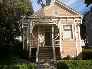
The Alkali Flat Historic District is a historic district in Sacramento, California. It is the oldest surviving neighborhood in Sacramento. The older Alkali Flat buildings and homes were built between 1853 and 1869 by the Sacramento's upper class. Alkali Flat borders are: 12th Street, H Street, 7th Street, and Southern Pacific Train tracks to the north.
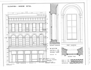
Adams and Company Building is an historical brick and granite building in Sacramento, California used for pioneer communications, finance and transportation servies. The Adams and Company Building is a California Historical Landmark No. 607. The Adams and Company Building is located at 1014 2nd Street in Old Sacramento State Historic Park. Adams and Company closed after its bank, Page, Bacon & Company failed in 1855.

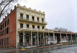
Western Hotel, was an historical hotel in Sacramento, California. The site of the former hotel is an California Historical Landmark No. 601 listed on May 22, 1957. The Western Hotel was at/near the intersection of 2nd street and K Street, Sacramento and owned by William Land. The site is now a Parking lot under the Interstate 5 in California.
.

Sheldon Grist Mill Site, is historical site in Sloughhouse, California in Sacramento County. The site is a California Historical Landmark No. 604 listed on June 2, 1949. The water powered gristmill, was used turn grain into flour, was on Rancho Omochumnes. The gristmill was built by Jared Dixon (Joaquin) Sheldon. Sheldon was grant then five square league of land on Rancho Omochumnes by the First Mexican Republic in 1843 by Mexican Governor Manuel Micheltorena as payment for carpenter work on the Monterey Custom House. Sheldon born on January 8, 1813, in Vermont and travelled to California 1832, working as a carpenter and millwright. Sheldon married Catherine Rhoads, the daughters of Thomas Rhoads in March 1847. Sheldon and his partner, William Daylor, also did some gold mining. Sheldon built a dam on Clark's Bar river on the his Sheldon Grant to irrigate the crops on his lands. The dam flood a California Gold Rush miners' claims. The angry miners' shot Sheldon on July 11, 1851. The conflict with Sheldon and the miners is called the Riot on the Cosumnes. In the conflict Sheldon was not the only one shot. Also Killed was James M. Johnson of Lancaster, Iowa and Edward Cody of Fox River, Illinois. Three were wounded: Calvin Dickerson of Berrien County, Michigan, Emanuel Bush of Des Moines County, Iowa and one unnamed miner. The Sheldon Grant was boarded on the south by the Cosumnes River and north by Deer Creek, 17 miles long between the rivers. The Sheldon Grist Mill was just west of the Sloughhouse Pioneer Cemetery, where Sheldon and his partner William Daylor and are buried. The site today is still mostly farmland.
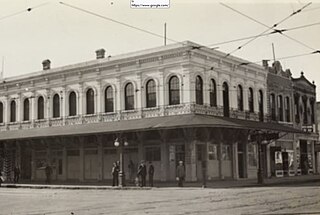
Overton Building was a historical two-story building in Sacramento, California. The site of former Overton Building is a California Historical Landmark No. 610 listed on May 22, 1956. This site is now a Parking lot near the corner of 2nd street and J Street in Old Sacramento State Historic Park. The Overton Building was removed when the Interstate 5 freeway was built in the 1960s. The historical Western Hotel, D.O. Mills Bank and the original Sacramento Bee building were also taken down for the I-5 freeway. The Overton Building first housed a number of California state offices including: the California Governor's Office and the California Secretary of State. The building, on the lot before the Overton Building, was lost in a fire on November 2, 1852. The first California State Library was housed on the second floor from 1853 to 1856. The building was built by the bankers, Read & Company at a cost $105,000 in 1852. In the 1950s and early 1960s Overton Building was the Rialto Hotel and Rialto Cafe.
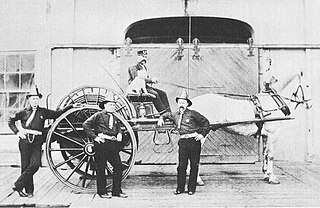
Pioneer Firehouse was the first Firehouse in Sacramento, California built in 1854. The site of the Firehouse is a California Historical Landmark No. 612 listed on May 22, 1957. Pioneer Firehouse was run by the Sacramento Fire Department, Engine Company #1. The Pioneer Firehouse was a two-story building on the corner of 3rd Street and J Street and is the oldest fire company of California. The Sacramento Fire Department founded on February 5, 1850.

Sacramento First Congregational Church, was the first church in Sacramento, California founded in 1849. The site of the First Congregational Church building is a California Historical Landmark No. 612 listed on May 22, 1957. The first church in Sacramento was founded in 1849 by Rev. Joseph A. Benton. Benton was the pastor from 1849 to 1863. The Church building was at 915 6th Street, built in 1854. A cornerstone ceremony was held on September 21, 1854. Before the church building was built the Church used a small one-room schoolhouse on the northwest corner of I and 3rd Streets, 303 I Street, in Old Sacramento. The attendees at the founding were mostly Swiss and German settlers of Sutter's Fort and New Helvetia. The church grew with the California Gold Rush pioneers coming to California. The site is now an office building on L Street. In 1926 Pioneer Congregational Church built a new church building, its third building, at 2700 L street, that is still in used.

The Home of Mrs. John Brown is a Victorian house built in 1865 at 135 Main St., Red Bluff, in Tehama County, California. The home that Mrs. John Brown (1816–1884) lived in is a California Historical Landmark No. 117 listed on March 29, 1933. At the time Mrs. John Brown was the widow of famous abolitionist John Brown (1800–1859).

