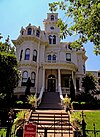
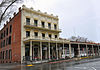
Old Sacramento State Historic Park occupies around one third of the property within the Old Sacramento Historic District of Sacramento, California. The Old Sacramento Historic District is a U.S. National Historic Landmark District. The Historic District is sometimes abbreviated as Old Sacramento, or Old Sac, and since the 1960s has been restored and developed as a significant tourist attraction.

State Route 49 is a north–south state highway in the U.S. state of California that passes through many historic mining communities of the 1849 California gold rush and it is known as the Golden Chain Highway. The highway's creation was lobbied by the Mother Lode Highway Association, a group of locals and historians seeking a single highway to connect many relevant locations along the Gold Rush to honor the 49ers. One of the bridges along SR 49 is named for the leader of the association, Archie Stevenot.
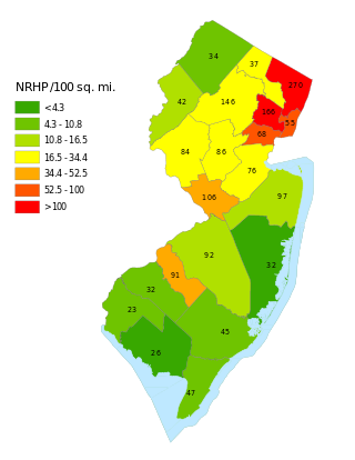
This is a list of properties and districts listed on the National Register of Historic Places in New Jersey. There are more than 1,700 listed sites in New Jersey. Of these, 58 are further designated as National Historic Landmarks. All 21 counties in New Jersey have listings on the National Register.
This National Park Service list is complete through NPS recent listings posted May 10, 2024.

El Dorado is an unincorporated community in El Dorado County, California. It is located 4 miles (6.4 km) southwest of Placerville, at an elevation of 1608 feet. The population was 4,096 at the 2000 census. The town is registered as California Historical Landmark #486. The ZIP code is 95623. The community is inside area code 530.

The Pony Express Terminal, also known as the B. F. Hastings Bank Building, is a historic commercial building at 1000 2nd Street in Sacramento, California. Built in 1852, it was the western endpoint of the Pony Express from 1860 to 1861, the period of the service's operation. It was declared a National Historic Landmark in 1966. It now houses a museum dedicated to the history of Wells Fargo, and is part of Old Sacramento State Historic Park, itself a National Historic Landmark District. The B. F. Hastings Bank Building is a California Historical Landmark No. 606.
Meyers is a small unincorporated community in El Dorado County, California, United States, along U.S. Route 50 in the northern Sierra Nevada. It is 6 miles (10 km) south of South Lake Tahoe in the Lake Tahoe area and lies at an elevation of 6,352 feet. Established in 1851, Meyers started out as a stagecoach stop, trading post and Pony Express station. The town is now registered as California Historical Landmark #708. It serves as a popular stop on the way into and out of the Tahoe Basin for travelers on Highway 50 and Highway 89.

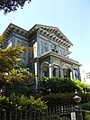
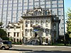
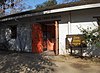
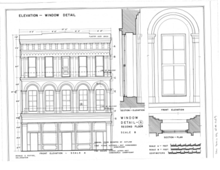
The Big Four Building is a historic 19th-century building in Downtown Sacramento, California. It is now located within Old Sacramento State Historic Park and the Old Sacramento National Historic District.

This is intended to be a complete list of the properties and districts on the National Register of Historic Places in Santa Clara County, California, United States. Latitude and longitude coordinates are provided for many National Register properties and districts; these locations may be seen together in an online map.

This is a list of the National Register of Historic Places listings in Sacramento County, California.

This is a list of the National Register of Historic Places listings in Clay County, Minnesota. It is intended to be a complete list of the properties and districts on the National Register of Historic Places in Clay County, Minnesota, United States. The locations of National Register properties and districts for which the latitude and longitude coordinates are included below, may be seen in an online map.
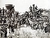
The Western Pacific Railroad (1862–1870) was formed in 1862 to build a railroad from Sacramento, California, to the San Francisco Bay, the westernmost portion of the First transcontinental railroad. After the completion of the railroad from Sacramento to Alameda Terminal on September 6, 1869, and then the Oakland Pier on November 8, 1869, which was the Pacific coast terminus of the transcontinental railroad, the Western Pacific Railroad was absorbed in 1870 into the Central Pacific Railroad.

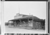
The Lyons Station Stagecoach Stop,, was a tavern and stagecoach stop near the southwest corner of Newhall Avenue and Sierra Highway, by Eternal Valley Cemetery. The site is located in the present day Newhall section of Santa Clarita, in Los Angeles County, California.
This list includes properties and districts listed on the California Historical Landmark listing in San Joaquin County, California. Click the "Map of all coordinates" link to the right to view a Google map of all properties and districts with latitude and longitude coordinates in the table below.
This is a list of the properties and districts — listed as California Historical Landmarks — within Sonoma County, California.
List table of the properties and districts — listed on the California Historical Landmarks — within Santa Barbara County, California.

Hangman's Tree was a tree in Placerville, California. The site of the tree is a California Historical Landmark No. 141, in El Dorado County, California. The stump of the tree is now under the building at 305 Main Street. During the California Gold Rush, the city was called Dry Diggins after the gold mining camp, but was known as Hangtown, as vigilantes hung many men for different types of crimes. During the Gold Rush, the site was Elstner's Hay Yard, next to the Jackass Inn. Hangtown was later renamed Placerville.
Adams and Company Building is an historical brick and granite building in Sacramento, California used for pioneer communications, finance and transportation servies. The Adams and Company Building is a California Historical Landmark No. 607. The Adams and Company Building is located at 1014 2nd Street in Old Sacramento State Historic Park. Adams and Company closed after its bank, Page, Bacon & Company failed in 1855.

Pioneer Telegraph Station, is historical building in Sacramento, California. The building is a California Historical Landmark No. 366 listed on October 9, 1939. From 1863 to 1868 the building housed the State Telegraph Company. From 1868 to 1915 the building housed the Union Telegraph Company. The Pioneer Telegraph Station Building is part of the Old Sacramento State Historic Park. The Pioneer Telegraph Station Building is sometimes confused with the Pony Express Terminal building, also in Old Sacramento State Historic Park.

Old California Oregon Road is a historical site in Anderson, California, in Shasta County. Old California Oregon Road site is California Historical Landmark No. 58 listed on December 6, 1932. The Old California Oregon Road was the main road used by pioneer travelers between the Trinity River and the northern gold mines of California and Oregon. The main part of the Old California Oregon Road ran from Portland to Sacramento.

Plum Valley House was built in 1854 by John Bope by hand. The Plum Valley House is a California Historical Landmark No. 695 listed on September 11, 1959. Bope built the Plum Valley House from hand hewn logs and whipsawn cut lumber. Bope house was named for the many wild plums which grow on the land near the house. The Plum Valley House was a toll station for travelers heading west on the Henness Pass Road between Marysville and Virginia City. Many for the travelers came west looking for gold in the California Gold Rush. The toll road was owned by the Henness Pass Turnpike Company, originally called the Truckee Turnpike Company founded in 1859. The Henness Pass toll closed after the completion of the First transcontinental railroad in 1868.