James Lick was an American real estate investor, carpenter, piano builder, land baron, and patron of the sciences. The wealthiest man in California at the time of his death, Lick left the majority of his estate to social and scientific causes.

Old Sacramento State Historic Park occupies around one third of the property within the Old Sacramento Historic District of Sacramento, California. The Old Sacramento Historic District is a U.S. National Historic Landmark District. The Historic District is sometimes abbreviated as Old Sacramento, or Old Sac, and since the 1960s has been restored and developed as a significant tourist attraction.

Arrowhead Springs is a highly mountainous neighborhood in the 81-square-mile (210 km2) municipality of San Bernardino, California, officially annexed to the city on November 19, 2009. The neighborhood lies below the Arrowhead geological monument, which is California Historical Landmark #977.

Monterey State Historic Park is a historic state park in Monterey, California. It includes part or all of the Monterey Old Town Historic District, a historic district that includes 17 contributing buildings and was declared a National Historic Landmark in 1970. The grounds include California's first theatre, and the Monterey Custom House, where the American flag was first raised over California.

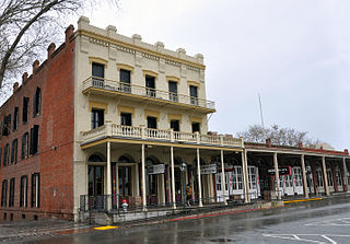
The Palace Hotel is a landmark historic hotel in San Francisco, California, located at the southwest corner of Market and New Montgomery streets. The hotel is also referred to as the New Palace Hotel to distinguish it from the original 1875 Palace Hotel, which had been demolished after being gutted by the fire caused by the 1906 San Francisco earthquake.

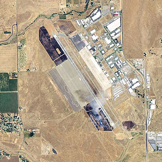
Sacramento Executive Airport is a public airport three miles (5 km) south of downtown Sacramento, in Sacramento County, California, United States. The airport covers 540 acres (219 ha) and has two lit runways and a helipad.
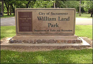
William Land Park, frequently referred to as simply "Land Park" is a major city park in Sacramento, California. The park is located between Interstate 5 and State Route 160.

The Capitol Mall or Capitol Mall Boulevard is a major street and landscaped parkway in the state capital city of Sacramento, California. Formerly known as M Street, it connects the city of West Sacramento in Yolo County to Downtown Sacramento. Capitol Mall begins at the eastern approach to the Tower Bridge, and runs east to 10th Street and the California State Capitol.
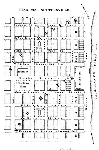
Sutterville is a former settlement in Sacramento County, California. It was located on the Southern Pacific Railroad 2.25 miles (3.6 km) south-southwest of Sacramento,

Harrington's Buildings is a heritage-listed hotel and former offices and store located at 53–65 George Street in the inner city Sydney suburb of The Rocks in the City of Sydney local government area of New South Wales, Australia. It was built from 1924 to 1925 by Concrete Constructions Limited. It is also known as Old Sydney Holiday Inn and Old Sydney Park Royal Hotel. The property is owned by Property NSW, an agency of the Government of New South Wales. It was added to the New South Wales State Heritage Register on 10 May 2002.
Chico Army Airfield auxiliary fields were a number of airfields used during World War II to support the Chico Army Airfield. On September 11, 1941, the US Army rented from the City of Chico a small 1930's airport that sat on 160 acres (0.65 km2) of land. The Airfield was five miles (8.0 km) north of the city center. The Army built up the small airport into the Chico Army Airfield. From the Chico Army Airfield operated the: United States Army Air Corps's Army Air Forces Basic Flying School, the Army Air Force Pilot School, the 10th Base Headquarters an Air Base Squadron and the 433rd Army Air Force Base Unit or Combat Crew Training Station of Fighter. To support the training of the many pilots, Chico Army Airfield operated a number of auxiliary airfields. Some auxiliary fields were no more than a landing strip runway, others were other operation airfield that supported the training at the Chico Army Airfield.

Casa del Rey Hotel was a resort hotel in Santa Cruz, California. During World War II the hotel was converted to the Naval Convalescent Hospital, Santa Cruz. The hotel was built in 1911 by Fred Swanton on Beach Street as a Santa Cruz Boardwalk development plan. The Resort Hotel had: a pool; gardens; and a grand pedestrian bridge to cross the street to visit the beach. The hotel was at about 500 Beach Street and Cliff Street. In addition to the hotel, there were built Cottage apartments. Later after the war the hotel became a senior citizen housing. In the 1989 Loma Prieta earthquake there was serious damage to the hotel and was taken down. The site now is the parking lot across the street from the Santa Cruz Beach Boardwalk amusement park.
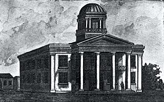
Sacramento First Courthouse also, Former California State Capitol site, is historical site in Sacramento, California. The Courthouse was also the first and second California State Capitol. The site is California Historical Landmark No. 869, registered on January 11, 1974. At the northwest corner of 7th Street and I Street, 651 I Street, Sacramento was a building that served as California's State Capitol. The first period was January 16, 1852 to May 4, 1852, and the second period was from March 1, 1854, to May 15, 1854, with the California State Legislature third and fifth sessions. The 651 I Street building was the Sacramento County courthouse. The site of former California State Capitol - Sacramento County courthouse is now the Main Sacramento County Jail built in 1989. A California Historical marker was place at the site in 2007 by California State Parks working the Sacramento Trust for Historic Preservation.
.

Pioneer Telegraph Station, is historical building in Sacramento, California. The building is a California Historical Landmark No. 366 listed on October 9, 1939. From 1863 to 1868 the building housed the State Telegraph Company. From 1868 to 1915 the building housed the Union Telegraph Company. The Pioneer Telegraph Station Building is part of the Old Sacramento State Historic Park. The Pioneer Telegraph Station Building is sometimes confused with the Pony Express Terminal building, also in Old Sacramento State Historic Park.
Overton Building was a historical two-story building in Sacramento, California. The site of former Overton Building is a California Historical Landmark No. 610 listed on May 22, 1956. This site is now a Parking lot near the corner of 2nd street and J Street in Old Sacramento State Historic Park. The Overton Building was removed when the Interstate 5 freeway was built in the 1960s. The historical Western Hotel, D.O. Mills Bank and the original Sacramento Bee building were also taken down for the I-5 freeway. The Overton Building first housed a number of California state offices including: the California Governor's Office and the California Secretary of State. The building, on the lot before the Overton Building, was lost in a fire on November 2, 1852. The first California State Library was housed on the second floor from 1853 to 1856. The building was built by the bankers, Read & Company at a cost $105,000 in 1852. In the 1950s and early 1960s Overton Building was the Rialto Hotel and Rialto Cafe.
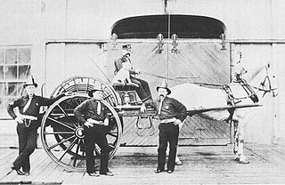
Pioneer Firehouse was the first Firehouse in Sacramento, California built in 1854. The site of the Firehouse is a California Historical Landmark No. 612 listed on May 22, 1957. Pioneer Firehouse was run by the Sacramento Fire Department, Engine Company #1. The Pioneer Firehouse was a two-story building on the corner of 3rd Street and J Street and is the oldest fire company of California. The Sacramento Fire Department founded on February 5, 1850.

Sacramento First Congregational Church, was the first church in Sacramento, California founded in 1849. The site of the First Congregational Church building is a California Historical Landmark No. 612 listed on May 22, 1957. The first church in Sacramento was founded in 1849 by Rev. Joseph A. Benton. Benton was the pastor from 1849 to 1863. The Church building was at 915 6th Street, built in 1854. A cornerstone ceremony was held on September 21, 1854. Before the church building was built the Church used a small one-room schoolhouse on the northwest corner of I and 3rd Streets, 303 I Street, in Old Sacramento. The attendees at the founding were mostly Swiss and German settlers of Sutter's Fort and New Helvetia. The church grew with the California Gold Rush pioneers coming to California. The site is now an office building on L Street. In 1926 Pioneer Congregational Church built a new church building, its third building, at 2700 L street, that is still in used.
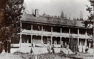
Southern's Stage Station was built in 1859 by Simeon Fisher Southern. The Southern's Stage Station site is on 9010 Mears Ridge Road, south of Castella, California in Shasta County. The Southern's Stage Station is a California Historical Landmark No. 33 listed on August 1, 1932. Simeon Fisher Southern and his Sarah Southern operated the Stagecoach Station wife Southern's Stage Station and Southern Hotel were log cabin building built in 1859. Travelers on the stagecoach or riding through could stop for rest and food for the 50 years this station operated till 1909. The town was called Hazel Creek, California, but change to Sims, California in 1871 as Southern's Stage Station and store was the center of the town.


