
John Augustus Sutter, born Johann August Sutter and known in Spanish as Don Juan Sutter, was a Swiss immigrant who became a Mexican and later an American citizen, known for establishing Sutter's Fort in the area that would eventually become Sacramento, California, the state's capital. His employee James W. Marshall discovered gold, leading to the founding of the mill-making team at Sutter's Mill. Sutter, however, saw his own business ventures fail during the California Gold Rush, though those of his elder son, John Augustus Sutter Jr., were more successful.

Sacramento is the capital city of the U.S. state of California and the seat of Sacramento County. Located at the confluence of the Sacramento and American Rivers in Northern California's Sacramento Valley, Sacramento's 2020 population of 524,943 makes it the fourth-most populous city in Northern California, sixth-most populous city in the state, and the ninth-most populous state capital in the United States. Sacramento is the seat of the California Legislature and the Governor of California.
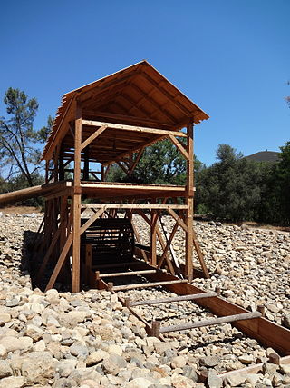
Sutter's Mill was a water-powered sawmill on the bank of the South Fork American River in the foothills of the Sierra Nevada in California. It was named after its owner John Sutter. A worker constructing the mill, James W. Marshall, found gold there in 1848. This discovery set off the California gold rush (1848–1855), a major event in the history of the United States.

Sutter's Fort was a 19th-century agricultural and trade colony in the Mexican Alta California province. Established in 1839, the site of the fort was originally part of a utopian colonial project called New Helvetia by its builder John Sutter, though construction of the fort proper would not begin until 1841. The fort was the first non-Indigenous community in the California Central Valley, and saw grave mistreatment of Indigenous laborers in plantation or feudal style conditions. The fort is famous for its association with the Donner Party, the California Gold Rush, and the formation of the city of Sacramento, surrounding the fort. It is notable for its proximity to the end of the California and Siskiyou Trails, which it served as a waystation.

The Sacramento River is the principal river of Northern California in the United States and is the largest river in California. Rising in the Klamath Mountains, the river flows south for 400 miles (640 km) before reaching the Sacramento–San Joaquin River Delta and San Francisco Bay. The river drains about 26,500 square miles (69,000 km2) in 19 California counties, mostly within the fertile agricultural region bounded by the Coast Ranges and Sierra Nevada known as the Sacramento Valley, but also extending as far as the volcanic plateaus of Northeastern California. Historically, its watershed has reached as far north as south-central Oregon where the now, primarily, endorheic (closed) Goose Lake rarely experiences southerly outflow into the Pit River, the most northerly tributary of the Sacramento.

The Maidu are a Native American people of northern California. They reside in the central Sierra Nevada, in the watershed area of the Feather and American Rivers and in Humbug Valley. In Maiduan languages, maidu means "man".

Old Sacramento State Historic Park occupies around one third of the property within the Old Sacramento Historic District of Sacramento, California. The Old Sacramento Historic District is a U.S. National Historic Landmark District. The Historic District is sometimes abbreviated as Old Sacramento, or Old Sac, and since the 1960s has been restored and developed as a significant tourist attraction.
New Helvetia, meaning "New Switzerland", was a 19th-century Alta California settlement and rancho, centered in present-day Sacramento, California.
Coloma is a census-designated place in El Dorado County, California, US. It is approximately 36 miles (58 km) northeast of Sacramento, California. Coloma is most noted for being the site where James W. Marshall found gold in the Sierra Nevada foothills, at Sutter's Mill on January 24, 1848, leading to the California Gold Rush. Coloma's population is 529.

The Folsom Lake State Recreation Area surrounds Folsom Lake in the foothills of the Sierra Nevada. The majority of it is owned by the U.S. Bureau of Reclamation and is managed by the California Department of Parks and Recreation. It is located near the city of Folsom, California, about 25 miles (40 km) east of Sacramento.

The Sutter Buttes are a small circular complex of eroded volcanic lava domes which rise as buttes above the flat plains of the Sacramento Valley in Sutter County, northern California. They are situated just outside Yuba City in the northern part of the state's Central Valley.

Indian Grinding Rock State Historic Park is a California State Park, preserving an outcropping of marbleized limestone with some 1,185 mortar holes—the largest collection of bedrock mortars in North America. It is located in the Sierra Nevada foothills, 8 miles (13 km) east of Jackson. The park is nestled in a little valley 2,400 feet (732 m) above sea level, with open meadows and large specimens of valley oak that once provided the Miwok peoples of this area with an ample supply of acorns. The 135-acre (55 ha) park was established in 1962 and listed on the National Register of Historic Places in 1971.

The Yuba River is a tributary of the Feather River in the Sierra Nevada and eastern Sacramento Valley, in the U.S. state of California. The main stem of the river is about 40 miles (64 km) long, and its headwaters are split into three major forks. The Yuba River proper is formed at the North Yuba and Middle Yuba rivers' confluence, with the South Yuba joining a short distance downstream. Measured to the head of the North Yuba River, the Yuba River is just over 100 miles (160 km) long.
The history of Sacramento, California, began with its founding by Samuel Brannan and John Augustus Sutter, Jr. in 1848 around an embarcadero that his father, John Sutter, Sr. constructed at the confluence of the American and Sacramento Rivers a few years prior.

The Nisenan are a group of Native Americans and an Indigenous people of California from the Yuba River and American River watersheds in Northern California and the California Central Valley. According to a 1929 archeology and ethnology press release by University of California, Berkeley, the Nisenan people are classified as part of the larger group of Native Americans known as the Maidu, though some dispute the accuracy of this relationship, including the Nisesan themselves. According to the Nisenan website, the United States' claim that they are Maidu is a misclassification and is inaccurate. As the Nisenan put it,
"Like many other Tribes throughout the United States, the Nisenan have been misidentified and mislabeled. The Nisenan have been lumped together under inaccurate labels such as "Maidu", "digger" and "southern Maidu". However, the Nisenan are a separate Tribe with their own Cultural lifeways, their own leaders and holy people, a distinct geographic territory and their own ancient and unique language."

The Toolesboro Mound Group, a National Historic Landmark, is a group of Havana Hopewell culture earthworks on the north bank of the Iowa River near its discharge into the Mississippi. The mounds are owned and displayed to the public by the State Historical Society of Iowa. The mound group is located east of Wapello, Iowa, near the unincorporated community of Toolesboro.

The American River is a 30-mile-long (50 km) river in California that runs from the Sierra Nevada mountain range to its confluence with the Sacramento River in downtown Sacramento. Via the Sacramento River, it is part of the San Francisco Bay watershed. This river is fed by the melting snowpack of the Sierra Nevada and its many headwaters and tributaries, including its North, Middle, and South Forks.

Stony Creek is a 73.5-mile (118.3 km)-long tributary of the Sacramento River in Northern California. It drains a watershed of more than 700 square miles (1,800 km2) on the west side of the Sacramento Valley in Glenn, Colusa, Lake and Tehama Counties.
New Helvetia Cemetery, initially named Sutter Fort Burying Ground, is a defunct cemetery founded in c. 1845 and closed in 1912, formerly located at the northeast corner of Alhambra Boulevard and J Street in the East Sacramento neighborhood of Sacramento, California. It was the first cemetery in the city of Sacramento.

China Slough, is historical site in Sacramento, California. The site of the former China Slough is California Historical Landmark No. 594, registered on May 22, 1957. The site of California Historical Landmark China Slough is the northeast corner of 4th Street and I Street in Sacramento at about 401 I Street. Before the China Slough was filled in, the waterway ran from 3rd Street to 5th Streets to north of I Street in Sacramento. The site became the Central Pacific Railroad Sacramento station built in 1910. The 1910 station had a wooden Trestle bridge built over the China Slough. A new depot was built nearby, the Sacramento Valley Station in 1926 and is now operated by Amtrak. The China Slough ran almost where the current Amtrak train tracks run today.


