Related Research Articles

A geographic information system (GIS) consists of integrated computer hardware and software that store, manage, analyze, edit, output, and visualize geographic data. Much of this often happens within a spatial database; however, this is not essential to meet the definition of a GIS. In a broader sense, one may consider such a system also to include human users and support staff, procedures and workflows, the body of knowledge of relevant concepts and methods, and institutional organizations.

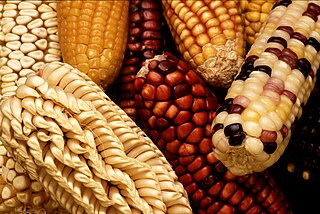
The potato is a starchy root vegetable native to the Americas that is consumed as a staple food in many parts of the world. Potatoes are tubers of the plant Solanum tuberosum, a perennial in the nightshade family Solanaceae.
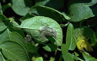
Phytophthora infestans is an oomycete or water mold, a fungus-like microorganism that causes the serious potato and tomato disease known as late blight or potato blight. Early blight, caused by Alternaria solani, is also often called "potato blight". Late blight was a major culprit in the 1840s European, the 1845–1852 Irish, and the 1846 Highland potato famines. The organism can also infect some other members of the Solanaceae. The pathogen is favored by moist, cool environments: sporulation is optimal at 12–18 °C (54–64 °F) in water-saturated or nearly saturated environments, and zoospore production is favored at temperatures below 15 °C (59 °F). Lesion growth rates are typically optimal at a slightly warmer temperature range of 20 to 24 °C.

Selective breeding is the process by which humans use animal breeding and plant breeding to selectively develop particular phenotypic traits (characteristics) by choosing which typically animal or plant males and females will sexually reproduce and have offspring together. Domesticated animals are known as breeds, normally bred by a professional breeder, while domesticated plants are known as varieties, cultigens, cultivars, or breeds. Two purebred animals of different breeds produce a crossbreed, and crossbred plants are called hybrids. Flowers, vegetables and fruit-trees may be bred by amateurs and commercial or non-commercial professionals: major crops are usually the provenance of the professionals.

Genetic diversity is the total number of genetic characteristics in the genetic makeup of a species. It ranges widely, from the number of species to differences within species, and can be correlated to the span of survival for a species. It is distinguished from genetic variability, which describes the tendency of genetic characteristics to vary.

Geographic Resources Analysis Support System is a geographic information system (GIS) software suite used for geospatial data management and analysis, image processing, producing graphics and maps, spatial and temporal modeling, and visualizing. It can handle raster, topological vector, image processing, and graphic data.
Agricultural biodiversity or agrobiodiversity is a subset of general biodiversity pertaining to agriculture. It can be defined as "the variety and variability of animals, plants and micro-organisms at the genetic, species and ecosystem levels that sustain the ecosystem structures, functions and processes in and around production systems, and that provide food and non-food agricultural products.” It is managed by farmers, pastoralists, fishers and forest dwellers, agrobiodiversity provides stability, adaptability and resilience and constitutes a key element of the livelihood strategies of rural communities throughout the world. Agrobiodiversity is central to sustainable food systems and sustainable diets. The use of agricultural biodiversity can contribute to food security, nutrition security, and livelihood security, and it is critical for climate adaptation and climate mitigation.
A transport network, or transportation network, is a network or graph in geographic space, describing an infrastructure that permits and constrains movement or flow. Examples include but are not limited to road networks, railways, air routes, pipelines, aqueducts, and power lines. The digital representation of these networks, and the methods for their analysis, is a core part of spatial analysis, geographic information systems, public utilities, and transport engineering. Network analysis is an application of the theories and algorithms of graph theory and is a form of proximity analysis.
System for Automated Geoscientific Analyses is a geographic information system (GIS) computer program, used to edit spatial data. It is free and open-source software, developed originally by a small team at the Department of Physical Geography, University of Göttingen, Germany, and is now being maintained and extended by an international developer community.
A GIS software program is a computer program to support the use of a geographic information system, providing the ability to create, store, manage, query, analyze, and visualize geographic data, that is, data representing phenomena for which location is important. The GIS software industry encompasses a broad range of commercial and open-source products that provide some or all of these capabilities within various information technology architectures.
Rebecca J. Nelson is an American biologist and a professor at Cornell University and a MacArthur Foundation Fellow.
ArcGIS is a family of client, server and online geographic information system (GIS) software developed and maintained by Esri.

Spatial analysis is any of the formal techniques which studies entities using their topological, geometric, or geographic properties. Spatial analysis includes a variety of techniques using different analytic approaches, especially spatial statistics. It may be applied in fields as diverse as astronomy, with its studies of the placement of galaxies in the cosmos, or to chip fabrication engineering, with its use of "place and route" algorithms to build complex wiring structures. In a more restricted sense, spatial analysis is geospatial analysis, the technique applied to structures at the human scale, most notably in the analysis of geographic data. It may also be applied to genomics, as in transcriptomics data.
GIS or Geographic Information Systems has been an important tool in archaeology since the early 1990s. Indeed, archaeologists were early adopters, users, and developers of GIS and GIScience, Geographic Information Science. The combination of GIS and archaeology has been considered a perfect match, since archaeology often involves the study of the spatial dimension of human behavior over time, and all archaeology carries a spatial component.
Geomorphometry, or geomorphometrics, is the science and practice of measuring the characteristics of terrain, the shape of the surface of the Earth, and the effects of this surface form on human and natural geography. It gathers various mathematical, statistical and image processing techniques that can be used to quantify morphological, hydrological, ecological and other aspects of a land surface. Common synonyms for geomorphometry are geomorphological analysis, terrain morphometry, terrain analysis, and land surface analysis. Geomorphometrics is the discipline based on the computational measures of the geometry, topography and shape of the Earth's horizons, and their temporal change. This is a major component of geographic information systems (GIS) and other software tools for spatial analysis.

MapWindow GIS is a lightweight open-source GIS (mapping) desktop application and set of programmable mapping components.
Geographic information systems (GISs) have become a useful and important tool in the field of hydrology to study and manage Earth's water resources. Climate change and greater demands on water resources require a more knowledgeable disposition of arguably one of our most vital resources. Because water in its occurrence varies spatially and temporally throughout the hydrologic cycle, its study using GIS is especially practical. Whereas previous GIS systems were mostly static in their geospatial representation of hydrologic features, GIS platforms are becoming increasingly dynamic, narrowing the gap between historical data and current hydrologic reality.
Search-based software engineering (SBSE) applies metaheuristic search techniques such as genetic algorithms, simulated annealing and tabu search to software engineering problems. Many activities in software engineering can be stated as optimization problems. Optimization techniques of operations research such as linear programming or dynamic programming are often impractical for large scale software engineering problems because of their computational complexity or their assumptions on the problem structure. Researchers and practitioners use metaheuristic search techniques, which impose little assumptions on the problem structure, to find near-optimal or "good-enough" solutions.

A Vavilov center or center of origin is a geographical area where a group of organisms, either domesticated or wild, first developed its distinctive properties. They are also considered centers of diversity. Centers of origin were first identified in 1924 by Nikolai Vavilov.
OLIGO Primer Analysis Software is a software for DNA primer design. The first paper describing this software was published in 1989. The program is a real time PCR primer and probe search and analysis tool. It additionally performs siRNA and molecular beacon searches, open reading frame analysis, and restriction enzyme analysis. It was created and maintained by Wojciech Rychlik and Piotr Rychlik.
References
- Guarino, L.; Jarvis, A.; Hijmans, R. J.; Maxted, N. (2002). "36. Geographic Information Systems (GIS) and the Conservation and Use of Plant Genetic Resources". In Engels, J. M. M.; Ramanatha Rao, V.; Brown, A. H. D.; Jackson, M. T. (eds.). Managing Plant Genetic Diversity (PDF). IPGRI. pp. 387–404. Retrieved 8 March 2015.
- Hijmans, R. J.; Guarino, L.; Cruz, M.; Rojas, E. (2001). "Computer tools for spatial analysis of plant genetic resources data: 1. DIVA-GIS" (PDF). Plant Genetic Resources Newsletter (127): 15–19. Retrieved 8 March 2015.
- Hijmans, R. J.; Guarino, L.; M., Prem (January 2012). "DIVA-GIS Version 7.5 Manual" (PDF). Archived (PDF) from the original on 19 March 2015. Retrieved 8 March 2015.