Sriharikota is a Barrier island off the Bay of Bengal coast located in the Shar Project settlement of Tirupati district in Andhra Pradesh, India. It houses the Satish Dhawan Space Centre, one of the two satellite launch centres in India. Indian Space Research Organisation (ISRO) launches satellites using multistage rockets such as the Polar Satellite Launch Vehicle and the Geosynchronous Satellite Launch Vehicle from Sriharikota. Sriharikota is selected by ISRO because of it's proximity to the equator, it gives extra centripital force from the rotation of Earth.
A Postal Index Number refers to a six-digit code in the Indian postal code system used by India Post. On 15 August 2022, the PIN system celebrated its 50th anniversary.
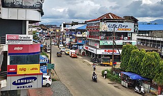
Vadakkencherry is a town and gram panchayat in the Palakkad district, state of Kerala, India. It is located about 35 km from Palakkad along National Highway 544.

Devarshola is a panchayat town in The Nilgiris district in the state of Tamil Nadu, India.
Malaj Khand is a town and a municipality in Balaghat district in the Indian state of Madhya Pradesh. This town has the biggest open copper mines in Asia and most of its population are the employed by the copper mines owned by the Central Government(Ministry of mines).
Mangrol is a town with municipality and tehsil in Baran district in the Indian state of Rajasthan. Pincode of Mangrol is 325215. It is the nearby location of famous Ramgarh crater made from the meteorite strike, also famous for the 11th century rock temple Bhand Deva Temple.
Pirayiri is a residential and commercial area in Palakkad city.It is located about 8 km (5.0 mi) from the city centre.It belongs to Pirayiri gram panchayat in the Palakkad district, state of Kerala, India.
Gudas, Belgaum is a village According to Census 2011 information the location code or village code of Gudas village is 597594. Gudas village is located in Hukeri taluka of Belgaum district in Karnataka, India. It is situated 11km away from sub-district headquarter Hukkeri and 63km away from district headquarter Belgaum. As per 2009 stats, Gudas village is also a gram panchayat.
Kovur is a town western part of Chennai City in the Kanchipuram district of the Indian state of Tamil Nadu. The town is a suburb of Chennai Metropolitan Area and is situated at a distance of about 5 kilometer's from Porur Chennai on the Porur-Kundrathur road.
Bijoynagar is a town in the Kamrup district. It is on the south bank of the river Brahmaputra.
Ongallur is a small town, gram panchayat in the Palakkad district, state of Kerala, India. It is a local government organisation serving the villages of Ongallur-I and Ongallur-II ongallur gramapanchayath have 2 village one is Vadanamkurussi P.O and two is Maruthur P.O Vadanamkurussi Pin code is 679121, maruthur Pincode is 679306.
Mundur is a town and gram panchayat in the Palakkad district, state of Kerala, India. Mundur is an important junction which connects National Highway 966 and State Highway 53. It is located about 11 km from Palakkad city and is one of the growing suburbs.
Kongad is a town and gram panchayat in Palakkad taluk, Kerala, India.It is a local government organisation that serves the villages of Kongad-I and Kongad-II.Kongad is located about 18 km from the district headquarters Palakkad.
Chadoora is a town and a Municipal committee in Budgam district in Indian administered union territory of Jammu and Kashmir. Famous sofi and aa'lim Mir Shams-ud-Din Araqi is buried here.
Buchpora is a town on the outskirts of Srinagar, Jammu and Kashmir, India. It is situated on Srinagar-Leh Highway on the eastern side of Anchar Lake. The postal code of the area is 190020. The area is about 12.1 km (7.5 mi) north from Lal Chowk. Most of the current inhabitants of the area are migrants from Downtown Srinagar. During the project of widening the roads in Downtown, numerous houses obstructing the widening of roads were shattered down. The homeless people were given plots of land by state government in neighbouring areas including Buchpora and Soura. Thus government housing colonies were constructed in these areas. there are many areas adjacent to this area, Illahi bagh, Rang pora, Umerhaira, are some of them. The area was an agriculture land but has been converted into a residential area.

Hazratbal is the notified area situated in Srinagar district of Jammu and Kashmir. It is about 10 km (6.2 mi) from Srinagar city center. The early settlements in the area occurred on the banks of Dal Lake and majority of population of area are Hangis (fishermen). The area became famous after the construction of Hazratbal Shrine where hundreds of thousands of people visit every year because many relics related to the Islamic prophet Muhammad are believed to be there.
Dagaon is a village in Kamrup district of Assam, India. It is situated on the north bank of the Brahmaputra River.

Chinakurali is a village in Pandavapura, Mandya, Karnataka, India.
Bagur is a small village located at Channarayapatna taluka of Hassan district in Karnataka state of India.
Naudiha Bazar is a small town in the Indian state of Jharkhand. It is the headquarters of Palamu division and Palamu district, and subdivision Chhatarpur and block of the Naudiha Bazar block.

