
Chandragupta Maurya was Emperor of Magadha from 322 BC to 297 BC and founder of the Maurya dynasty which ruled over a geographically-extensive empire based in Magadha. He reigned from 320 BCE to 298 BCE. The Magadha kingdom expanded to become an empire that reached its peak under the reign of his grandson, Ashoka the Great, from 268 BCE to 231 BCE. The nature of the political formation that existed in Chandragupta's time is not certain. The Mauryan empire was a loose-knit one with large autonomous regions within its limits.

Magadha also called the Kingdom of Magadha or the Magadha Empire, was a kingdom and empire, and one of the sixteen Mahajanapadas, 'Great Footholds of the People' during the Second Urbanization period, based in southern Bihar in the eastern Ganges Plain, in Ancient India. Magadha was ruled by the Brihadratha dynasty, the Pradyota dynasty, the Haryanka dynasty, the Shaishunaga dynasty, the Nanda dynasty, the Mauryan dynasty, the Shunga dynasty, the Kanva dynasty and the Gupta Empire. Kanva dynasty lost much of its territory after being defeated by the Satavahanas of Deccan in 28 BCE and was reduced to a small principality around Pataliputra. However, with the rule of Gupta Empire, The Gupta Empire regained the Glory of Magadh. Under the Mauryas, Magadha became a pan-Indian empire, covering large swaths of the Indian subcontinent and Afghanistan. The Magadh under the Gupta Empire emerged as the most prosperous Kingdom in the History of Ancient India.

The Maurya Empire was a geographically extensive Iron Age historical power in South Asia based in Magadha. It was the fourth ruling dynasty of Magadha. Founded by Chandragupta Maurya in 322 BCE, it existed in loose-knit fashion until 185 BCE. The empire was centralized by the conquest of the Indo-Gangetic Plain; its capital city was located at Pataliputra. Outside this imperial centre, the empire's geographical extent was dependent on the loyalty of military commanders who controlled the armed cities scattered within it. During Ashoka's rule, the empire briefly controlled the major urban hubs and arteries of the Indian subcontinent excepting the deep south. It declined for about 50 years after Ashoka's rule, and dissolved in 185 BCE with the assassination of Brihadratha by Pushyamitra Shunga and foundation of the Shunga dynasty in Magadha.

The Grand Trunk Road is one of Asia's oldest and longest major roads. For at least 2,500 years it has linked Central Asia to the Indian subcontinent. It runs roughly 3,655 km (2,271 mi) from Teknaf, Bangladesh on the border with Myanmar west to Kabul, Afghanistan, passing through Chittagong and Dhaka in Bangladesh, Kolkata, Kanpur, Agra, Aligarh, Delhi, Amritsar in India, and Lahore, Rawalpindi, and Peshawar in Pakistan.

Ujjain or Ujjayinī is a city in Ujjain district of the Indian state of Madhya Pradesh. It is the fifth-largest city in Madhya Pradesh by population and is the administrative centre of Ujjain district and Ujjain division. It is one of the Hindu pilgrimage centres of Sapta Puri famous for the Kumbh Mela (Simhastha) held there every 12 years. The famous temple of Mahakaleshwar Jyotirlinga is located in the center of the city. The city has been one of the most prominent trade and political centres of the Indian Subcontinent from the time of the ancient Mahājanapadas until the British colonisation of India.

The Satavahanas, also referred to as the Andhras in the Puranas, were an ancient Indian dynasty. Most modern scholars believe that the Satavahana rule began in the late second century BCE and lasted until the early third century CE, although some assign the beginning of their rule to as early as the 3rd century BCE based on the Puranas, but uncorroborated by archaeological evidence. The Satavahana kingdom mainly comprised the present-day Andhra Pradesh, Telangana, and Maharashtra. At different times, their rule extended to parts of modern Gujarat, Madhya Pradesh, and Karnataka. The dynasty had different capital cities at different times, including Kotalingala (Telangana), Pratishthana (Paithan) and Amaravati (Dharanikota).

Āryāvarta is a term for the northern Indian subcontinent in the ancient Hindu texts such as Dharmashastras and Sutras, referring to the areas of the Indo-Gangetic Plain and surrounding regions settled by Indo-Aryan tribes and where Indo-Aryan religion and rituals predominated. The limits of Āryāvarta extended over time, as reflected in the various sources, as the influence of the Brahmanical ideology spread eastwards in post-Vedic times.
Ancient Hindu and Buddhist texts use Uttarapatha as the name of the Northern part of Jambudvipa, one of the "continents" in Hindu mythology. In modern times, the Sanskrit word uttarapatha is sometimes used to denote the geographical regions of North India, Western India, Central India, Eastern India, Northeast India, Pakistan, Bangladesh, and Nepal in just one term. The pronunciation of the word varies depending on the regional language of the speaker.
The Mahājanapadas were sixteen kingdoms and aristocratic republics that existed in ancient India from the sixth to fourth centuries BCE, during the second urbanisation period.
The Rishikas was an ancient Kingdom of Central Asia and South Asia, who are mentioned in Hindu and Sanskrit literary texts, including the Mahabharata, the Ramayana, the Brhat-Samhita, the Markendeya Purana and Patanjali's Mahabhashya.
Panchala was an ancient kingdom of northern India, located in the Ganges-Yamuna Doab of the Upper Gangetic plain which is identified as Kanyakubja or region around Kannauj. During Late Vedic times, it was one of the most powerful states of ancient India, closely allied with the Kuru Kingdom. By the c. 5th century BCE, it had become an oligarchic confederacy, considered one of the solasa (sixteen) mahajanapadas of the Indian subcontinent. After being absorbed into the Mauryan Empire, Panchala regained its independence until it was annexed by the Gupta Empire in the 4th century CE.

The Northern Black Polished Ware culture is an urban Iron Age Indian culture of the Indian subcontinent, lasting c. 700–200 BCE, succeeding the Painted Grey Ware culture and Black and red ware culture. It developed beginning around 700 BCE, in the late Vedic period, and peaked from c. 500–300 BCE, coinciding with the emergence of 16 great states or Mahajanapadas in Northern India, and the subsequent rise of the Mauryan Empire.
Asmaka or Assaka was a Mahajanapada in ancient India which existed between 700 BCE and 425 or 345 BCE according to the Buddhist texts Anguttara Nikaya and Puranas. It included areas in present-day Andhra Pradesh, Telangana and Maharashtra. In Gautama Buddha's time, many of the Assakas were located on the banks of the Godavari River. Its capital is variously called Potali or Podana, and is identified as present-day Bodhan in Telangana.
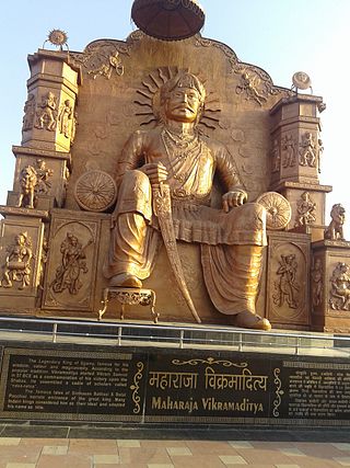
Vikramaditya was a legendary king as mentioned in ancient Indian literature, featuring in traditional stories including those in Vetala Panchavimshati and Singhasan Battisi. Many describe him as ruler with his capital at Ujjain. "Vikramaditya" was also a common title adopted by several monarchs in ancient and medieval India, and the Vikramaditya legends may be embellished accounts of different kings. According to popular tradition, Vikramaditya began the Vikrama Samvat era in 57 BCE after defeating the Shakas, and those who believe that he is based on a historical figure place him around the first century BCE. However, this era is identified as "Vikrama Samvat" after the ninth century CE.

Kuru was a Vedic Indo-Aryan tribal union in northern Iron Age India of the Bharatas and other Puru clans. The Kuru kingdom appeared in the Middle Vedic period, encompassing parts of the modern-day states of Haryana, Delhi, and some parts of western Uttar Pradesh. The Kuru kingdom was the first recorded state-level society in the Indian subcontinent.
The Āndhras were an ancient tribe of south-central Indian subcontinent, whose existence is attested during the Iron Age. Andhras were mentioned in the ancient Hindu scriptures such as the Aitareya Brahmana, Ramayana, Mahabharata and Puranas. According to Aitareya Brahmana of the Rigveda, the Andhras left North India from the banks of river Yamuna and migrated to South India. The kingdom inhabited and ruled by Andhras was called Andhra, and was based in the Deccan region. The modern Indian state of Andhra Pradesh, derives its name from this historic tribe and region.

The Pahlavas are a people mentioned in ancient Indian texts. According to Patrick Carnegy, a Raj-era ethnographer, the 4th-century BCE Vartika of Katyayana mentions the Sakah-Parthavah, demonstrating an awareness of these Saka-Parthians, probably by way of commerce. Knowledge of the Pahlavas is distilled from the literary references in texts like the Manu Smriti, various Puranas, the Ramayana, the Mahabharata, and the Bṛhat Saṃhitā.

The history of Madhya Pradesh can be divided into three periods - the ancient period, the medieval period and modern period.

The Janapadas were the realms, republics (ganapada) and kingdoms (sāmarājya) of the Vedic period in the Indian subcontinent. The Vedic period reaches from the late Bronze Age into the Iron Age: from about 1500 BCE to the 6th century BCE. With the rise of sixteen Mahajanapadas, most of the states were annexed by more powerful neighbours, although some remained independent.
