
Superstition Mountain is a prominent mountain and regional landmark located in the Phoenix metropolitan area of Arizona, immediately east of Apache Junction and north of Gold Canyon. It anchors the west end of the federally designated Superstition Wilderness Area and is a popular outdoor recreation destination, home to numerous trails for hiking and horseback riding. The legend of the Lost Dutchman's Gold Mine centers around the mountain.

The Arizona National Scenic Trail is a National Scenic Trail from Mexico to Utah that traverses the whole north–south length of the U.S. state of Arizona. The trail begins at the Coronado National Memorial near the US–Mexico border and moves north through parts of the Huachuca, Santa Rita, and Rincon Mountains. The trail continues through the Santa Catalina north of Tucson and the Mazatzal Mountains before ascending the Mogollon Rim north of Payson, and eventually leading to the higher elevations of Northern Arizona and the San Francisco Peaks. The trail then continues across the Coconino Plateau and in and out of the Grand Canyon. The Arizona Trail terminates near the Arizona–Utah border in the Kaibab Plateau region. The 800-mile (1,300 km) long Arizona Trail was completed on December 16, 2011. The trail is designed as a primitive trail for hiking, equestrians, mountain biking, and even cross country skiing, showcasing the wide variety of mountain ranges and ecosystems of Arizona.

The Deseret Peak Wilderness is located in the Stansbury Mountains of Tooele County, Utah, United States near the towns of Tooele and Grantsville, not far from the Great Salt Lake. It is part of the Wasatch-Cache National Forest. This semi-arid wilderness is part of the Great Basin ecosystem. Elevations range from about 6,000 feet to the top of Deseret Peak's limestone escarpment at 11,031 feet (3,362 m). In this high country, with barren Skull Valley to the west, you'll find some springs and intermittent creeks, despite the general dryness of the area.

Lincoln National Forest is a unit of the U.S. Forest Service located in southern New Mexico. Established by Presidential Proclamation in 1902 as the Lincoln Forest Reserve, the 1,103,897 acres (4,467.31 km2) forest begins near the Texas border and contains lands in parts of Chaves, Eddy, Lincoln, and Otero counties. The three Ranger Districts within the forest contain all or part of four mountain ranges, and include a variety of different environmental areas, from desert to heavily forested mountains and sub-alpine grasslands. Established to balance conservation, resource management, and recreation, the lands of the Lincoln National Forest include important local timber resources, protected wilderness areas, and popular recreation and winter sports areas. The forest headquarters is located in Alamogordo, N.M. with local offices in Carlsbad, Cloudcroft, and Ruidoso.

Miller Peak, at 9,470 feet (2,886 m), is the second-highest mountain in Cochise County, Arizona. Located approximately 10 miles south of Sierra Vista, Arizona, it is the highest mountain in the Huachuca mountain range and a popular local hiking destination. The Miller Peak Wilderness encompasses 20,190 acres and is managed by the Coronado National Forest. This is also the most southerly peak and land area to rise above 9,000 feet in the continental United States. The area was affected by the 2011 Monument fire and most of the pine trees seen in older photographs were burned and destroyed. Scrub oak are beginning to replace the areas that were previously covered by pine.

The Santa Fe River is river in Santa Fe and Sandoval counties in New Mexico, United States, that is a tributary of the Rio Grande.
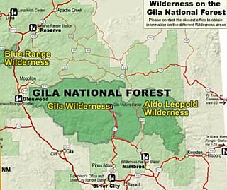
Gila Wilderness was designated the world's first wilderness area on June 3, 1924. Along with Aldo Leopold Wilderness and Blue Range Wilderness, the 558,014 acre wilderness is part of New Mexico's Gila National Forest. The wilderness is approximately 27 miles (43 km) from north to south and 39 miles (63 km) east to west. U.S. Wilderness Areas do not allow motorized or mechanized vehicles, including bicycles. Camping, hunting, and fishing are allowed with proper permit, but no roads, buildings, logging, or mining are permitted. Wilderness areas within National Forests and Bureau of Land Management areas allow hunting in season.
Jennie Lakes Wilderness is a protected area in the Sierra Nevada, in Tulare County, California. It is located 60 miles (97 km) east of Fresno and managed by the US Forest Service.
New Mexico State Road 4 (NM 4) is a 67.946-mile-long (109.348 km) state highway in Sandoval, Los Alamos, and Santa Fe counties in New Mexico, United States. It is significant as the main access route connecting the remote town of Los Alamos, Los Alamos National Laboratory, and Bandelier National Monument to other, more major highways in New Mexico.
Caja del Rio is a dissected plateau, of volcanic origin, which covers approximately 84,000 acres of land in northern Santa Fe County, New Mexico, United States. The region is also known as the Caja, Caja del Rio Plateau, and Cerros del Rio. The center of the area is approximately 15 miles (23 km) west of Santa Fe, New Mexico. Most of the Caja is owned by the United States Forest Service and managed by the Santa Fe National Forest. Access is through New Mexico Highway 599, Santa Fe County Road 62, and Forest Service Road 24.

The Santa Fe Rail Trail is a multi-use trail, part of the trail system in the city of Santa Fe, New Mexico. The trail begins at the Santa Fe Depot, in the Railyard arts district, and ends at U.S. Route 285, near Lamy, New Mexico and the Lamy station. An example of Rails with trails, it parallels the New Mexico Rail Runner Express tracks to roughly I-25, where it then continues along the Santa Fe Southern Railway. The Santa Fe Rail trail is 15 miles long, is asphalted for the first 3.5 miles, and improved natural surface for 11.5 miles. The last few miles between Eldorado and US-285 is unimproved natural surface.

The Dinkey Lakes Wilderness is a federally designated wilderness area located 45 miles (72 km) northeast of Fresno, in the state of California, United States. It comprises 30,000 acres (12,141 ha) within the Sierra National Forest and was added to the National Wilderness Preservation System by the California Wilderness Act of 1984. Elevations range from 8,200 feet (2,500 m) to 10,619 feet (3,237 m). Recreational activities in the wilderness include day hiking, backpacking, horseback riding, fishing, rock climbing and cross-country skiing.

Canaan Mountain Wilderness is a 44,531-acre (180.2 km2) wilderness area in the US state of Utah. It was designated March 30, 2009, as part of the Omnibus Public Land Management Act of 2009. Located near the town of Hildale in southeastern Washington County, it borders Zion National Park to the north, Kane County to the east, and the state of Arizona to the south.
The White Mountain Wilderness is a 46,963 acre designated wilderness area managed by the United States Forest Service. Located in the Smokey Bear Ranger District of the Lincoln National Forest, the White Mountain Wilderness lies in the Sierra Blanca mountains of south central New Mexico, approximately 15 miles (24 km) north northwest of the town of Ruidoso.
The Great Western Trail is a north-south long distance multiple use route which runs from Canada to Mexico through five western states in the United States. The trail has access for both motorized and non-motorized users and traverses 4,455 miles (7,170 km) through Arizona, Utah, Idaho, Wyoming, and Montana. It was designated a National Millennium Trail in 1999.

Cerro Grande is a 10,207-foot (3,111 m) summit on the rim of the Valles Caldera not far north of New Mexico State Road 4, the main highway through Los Alamos County. Like many mountains in the Jemez, Cerro Grande was mainly covered with coniferous forest, composed largely of ponderosa pine and aspen trees, with a characteristic rincon (meadow) on its slopes on and south of the summit.

The Ortiz Mountains are a mountain range in northern New Mexico, United States, in Santa Fe County, northeast of the Sandia Mountains and due north of the San Pedro Mountains. The Ortiz include Placer Peak, the highest peak in the range at 8,858 feet, Lone Mountain at 7,310 feet, Cedar Mountain at 7,041 feet, Cerro Chato at 6,965 feet, and the foothills known as the Los Lomas de la Bolsa.
Atalaya Mountain is a mountain peak located within the Santa Fe National Forest, in northern New Mexico, United States. It is part of the Santa Fe Mountains in the Sangre de Cristo Range, a subrange of the Southern Rocky Mountains. A relevant viewscape from the city of Santa Fe, there are no higher peaks between the city and Atalaya Mountain to the east. Viewed from the city, Atalaya Mountain is framed by Sun Mountain to the right (south), Picacho Peak to the left (north), and Thompson Peak behind it. Atalaya Mountain is accessible by following the Atalaya Trail, or via the Dale Ball Trails from the direction of Picacho Peak and trail marker number 36.
The Atalaya Trail is an out and back trail to the summit of Atalaya Mountain, in Santa Fe, New Mexico.
The Cerro Bola is a coastal metavolcanic mountain formation in northwestern Baja California. The Cerro Bola, along with the nearby mountain Cerro Gordo form the highest elevation areas of Tijuana Municipality. Because of its prominence, the transmitters for television station XHDTV and radio station XHPRS-FM are located on the summit of Cerro Bola, which reaches an elevation of 1,260 m (4,130 ft). It is located approximately 35 km (22 mi) south of the Tecate border crossing, and sits at the southwest end of the Valle de Las Palmas. The mountain range is host to a number of rare and endemic plant species, such as Arctostaphylos bolensis and Ceanothus bolensis.


