
Frederiksberg Runddel is a space in front of the main entrance to Frederiksberg Gardens, at the end of Frederiksberg Allé, in the Frederiksberg district of Copenhagen, Denmark.

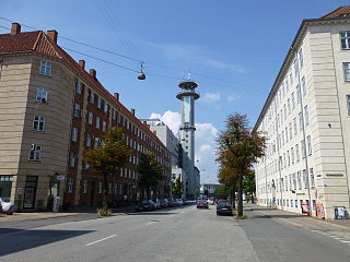
Frederiksberg Allé is a tree-lined avenue which runs through the southernmost part of the Frederiksberg district of Copenhagen, Denmark. It connects Vesterbrogade at Værnedamsvej to Frederiksberg Runddel in front of the main entrance to Frederiksberg Gardens. It was originally constructed in 1704 as the king's private road leading to his new summer residence, Frederiksberg Palace. It developed into the backbone of an entertainment district in the mid 18th century, and has continued to be associated with theatres until the present day. The avenue is lined with two double rows of linden trees and bisects Sankt Thomas Plads, a small round plaza, shortly after its departure from Vesterbrogade.
Borups Allé is a major artery in the northwestern part of inner Copenhagen, Denmark. The 3.2 km long street runs from Jagtvej at Nuuks Plads in the southeast to Bellahøj in the northwest. Just before Hulgårdsvej, part of Ring 2, Borups Allé is joined by Bispeengbuen, an elevated road section that connects it to Åboulevard-Ågade and H. C. Andersens Boulevard in the city centre. The rest of Borups Allé is the first leg of the National Road 16, part of the Danish national road network. It continues as a six-lane road to Frederikssundsvej where it becomes Hareskovvej and later the Hillerød Motorway at Utterslev Mose.

Åboulevard is a street in central Copenhagen, Denmark. Together with H. C. Andersens Boulevard in the city centre and Borups Allé, it forms a major artery in and out of the city. The road is built over Ladegårds Å, a canal originally built to supply Copenhagen with water, which still runs in a pipe under it, feeding water into Peblinge Lake.

H. C. Ørsteds Vej is a street in the Frederiksberg district of Copenhagen, Denmark. It runs from Gammel Kongevej in the south to Åboulevard on the border with Nørrebro in the north, linking Alhambravej in the south with Griffenfeldsgade in the north.
Bülowsvej is a street in the Frederiksberg district of Copenhagen, Denmark. It runs from Gammel Kongevej in the south to Åboulevard in the north, linking Madvigs Allé with Brohusgade. The University of Copenhagen's Frederiksberg Campus dominates the west side of the street with its large main building from 1895. The east side of the street is home to one of Denmark's oldest neighbourhoods of single family detached homes.

Frederiksberg Campus is one of the four main campuses of University of Copenhagen in Copenhagen, Denmark. It is located in Frederiksberg and is home to large parts of the Faculty of Science' activities within the fields of natural science and biosciences as well as part of the School of Veterinary Medicine and Animal Science at the Faculty of Health and Medical Sciences, including the University Hospital for Companion Animals. The main campus is located on the west side of Bülowsvej, on both sides of Thorvaldsensvej and Rolighedsvej. It occupies the former grounds of the Royal Veterinary and Agricultural University (KVL) which was merged into the University of Copenhagen in 2007. The main building at Bülowsvej No. 17 is from 1895.

Rosenørns Allé is a street located on the border between Frederiksberg and Nørrebro, on the west side of The Lakes, in Copenhagen, Denmark. The street branches from the south side of the busy thoroughfare Kampmannsgade-Åboulevard at the west end of the embankment which separates St. Jørgen's Lake from Peblinge Lake, runs west to Julius Thomsens Plads and then continues in a more northwesterly direction to Bülowsvej where it turns into Rolighedsvej and later Godthåbsvej before reaching Bellahøj in Brønshøj.

Godthåbsvej is a street in the northwestern part of Copenhagen, Denmark. It begins at Bülowsvej in Frederiksberg as the direct continuation of Rosenørns Allé/Rolighedsvej and passes through Vanløse before reaching Bellahøj in Brønshøj. A metro station on the Copenhagen Metro City Circle Line is located at Aksel Møllers Have.
Peter Bangs Vej is a 2.2 km long street in Frederiksberg, a city in the Copenhagen area on the island of Zealand, Denmark. The direct continuation of Smallegade, it initially runs west, from Nordre Fasanvej, but then turns south along the east side of Damhus Lake to meet Roskildevej. There is a large sports complex on the south end of the street with the football club F.C. Copenhagen's training facilities as well as the multi-purpose venue K.B. Hallen.

Nyelandsvej is a street in the Frederiksberg district of Copenhagen, Denmark. It runs from Falkoner Allé in the southeast to a roundabout at the north end of Dalgas Boulevard in the northwest. The more urban, eastern part of the street, between Falkoner Allé and Nordre Fasanvej, separates an area with Copenhagen Business School's Solbjerg Campus and Frederiksberg Centret to the south from the Svømmehal Quarter to the north. The western part of the street is passes the multi-purpose venue Keddelhallen and Frederiksberg Hospital before entering an area with Single-family detached homes.

Finsensvej is a major street in the Frederiksberg district of Copenhagen, Denmark. The direct continuation of Howitzvej, it runs from Nordre Fasanvej in the east to the northern end of Sønderjyllands Allé in the west where it turns into Jernbane Allé on the municipal border with Vanløse. The street crosses Dalgas Boulevard and passes under the S-train network's Frederikssund radial. The modern Flintholm neighbourhood is located on the north side of the street and the Lindevang Park on its south side. The street is named after the Nobel Prize-winning physician Niels Ryberg Finsen.

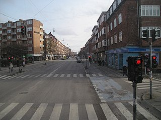
Jagtvej is a major artery in the Nørrebro and Østerbro districts of Copenhagen, Denmark. It runs from Ågade on the border with Frederiksberg in the southwest to Østerbrogade in the northeast, linking Falkoner Allé with Strandboulevarden. The street passes Assistens Cemetery, University of Copenhagen's North Campus and Fælled Park.

Vigerslev Allé is a major artery in the Valby district of Copenhagen, Denmark. It runs from Enghavevej in the northeast to Hvidovrevej in Hvidovre in the southwest. The first part of the street runs east-west, following the south side of the main railway line through Copenhagen on its way to Toftegårds Plads, the largest square in Valby. It later passes under the S-train network's Ring Line at Vigerslev Allé station before continuing southwest to the Ring 2 ring road just before entering Hvidovre Municipality at Harrestrup Å in Vigerslevparken.

Mariendalsvej is a street in the Frederiksberg district of Copenhagen, Denmark. It runs from Falkoner Allé in the southeast to the Ring Line in the northwest. The area to the southeast of Nordre Fasanvej runs through the Mariendal Quarter and the rest runs through the Fuglebakken neighbourhood.

Gyldenløvesgade is a street in central Copenhagen, Denmark. It runs from Jarmers Plads in the south east to a Y junction at the western side of The Lakes, linking H. C. Andersens Boulevard with Aaboulevarden and Rosenørns Allé. The last section of the street runs on an embankment which separates Peblinge Lake to the north from Sankt Jørgen's Lake to the south. The Lake Pavilion overlooks Peblinge Lake on the north side of the street.

Sønderjyllands Allé is a street in the Frederiksberg district of Copenhagen, Denmark. It runs from Peter Bangs Vej in the southeast to Finsensvej in the northwest.

Danasvej is a street in the Frederiksberg district of Copenhagen, Denmark, linking the Kampmannsgade embankment across St. Jørgen's Lake in the east with H. C. Ørsteds Vej in the west. The central, section of the street, from Vodroffsvej to Svend Trøsts Vej, is called Danas Plads but the street and square are continuously numbered. The Danas Plads buildings, built in 1906–1909 to a National Romantic design by Ulrik Plesner and Thorvald Bindesbøll, surrounds a rectangular, public space with greenery and a playground.

Kingosgade is a street straddling the border between Vesterbro and Frederiksberg in Copenhagen, Denmark. It runs from Vesterbrogade in the south to Frederiksberg Allé in the north, linking Enghavevej with Alhambravej.
Dronning Olgas Vej is a street in the Mariendal neighborhood of Frederiksberg in Copenhagen, Denmark. It runs from Falkoner Allé in the east to a modernist housing estate adjacent to Nordre Fasanvej in the west from where it turns south to join Kong Georgs Vej. The Modernist housing estate was built in the 1970s in the former grounds of the Stjernen cooperative brewery. Most of the other buildings in the street are single family detached homes from the late 19th and early 20th century.

