
The Moselle is a river that rises in the Vosges mountains and flows through north-eastern France and Luxembourg to western Germany. It is a left bank tributary of the Rhine, which it joins at Koblenz. A small part of Belgium is in its basin as it includes the Sauer and the Our.

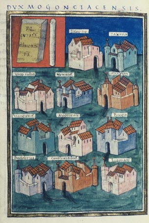
Gallia Belgica was a province of the Roman Empire located in the north-eastern part of Roman Gaul, in what is today primarily northern France, Belgium, and Luxembourg, along with parts of the Netherlands and Germany.
The Trēverī were a Germanic or Celtic tribe of the Belgae group who inhabited the lower valley of the Moselle in modern day Germany from around 150 BCE, if not earlier, until their displacement by the Franks. Their domain lay within the southern fringes of the Silva Arduenna, a part of the vast Silva Carbonaria, in what are now Luxembourg, southeastern Belgium and western Germany; its centre was the city of Trier, to which the Treveri give their name. Celtic in language, according to Tacitus they claimed Germanic descent. They contained both Gallic and Germanic influences.

Bitburg is a city in Germany, in the state of Rhineland-Palatinate approximately 25 km (16 mi.) northwest of Trier and 50 km (31 mi.) northeast of Luxembourg city. The American Spangdahlem Air Base is nearby.

This is a chronology of warfare between the Romans and various Germanic peoples. The nature of these wars varied through time between Roman conquest, Germanic uprisings, later Germanic invasions of the Western Roman Empire that started in the late second century BC, and more. The series of conflicts was one factor which led to the ultimate downfall of the Western Roman Empire in particular and ancient Rome in general in 476.
The Vangiones appear first in history as an ancient Germanic tribe of unknown provenance. They threw in their lot with Ariovistus in his bid of 58 BC to invade Gaul through the Doubs river valley and lost to Julius Caesar in a battle probably near Belfort. After some Celts evacuated the region in fear of the Suebi, the Vangiones, who had made a Roman peace, were allowed to settle among the Mediomatrici in northern Alsace.. They gradually assumed control of the Celtic city of Burbetomagus, later Worms.
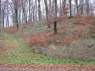
The Limes Germanicus is the name given in modern times to a line of frontier fortifications that bounded the ancient Roman provinces of Germania Inferior, Germania Superior and Raetia, dividing the Roman Empire and the unsubdued Germanic tribes from the years 83 to about 260 AD. The Limes used either a natural boundary such as a river or typically an earth bank and ditch with a wooden palisade and watchtowers at intervals. A system of linked forts was built behind the Limes.
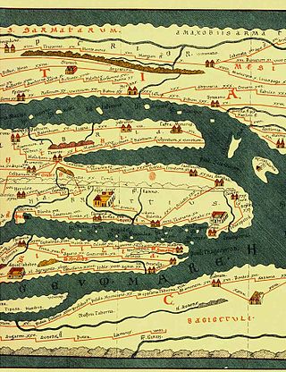
Tabula Peutingeriana, also referred to as Peutinger's Tabula or Peutinger Table, is an illustrated itinerarium showing the layout of the cursus publicus, the road network of the Roman Empire.
The Armalausi were an obscure Germanic tribe of late antiquity. Their name means "those who wear the armilausa", a type of shirt open at the front and back but connected at the shoulders.

Glannoventa is a Roman fort associated with the Roman naval base at Ravenglass in Cumbria, England. Its name is derived from the Latin place-name Clanoventa as recorded in the 2nd-century Antonine Itinerary, Glannibanta in the 4th-century Notitia Dignitatum, and Cantiventi in the 6th-century Ravenna Cosmography.
Celtic Luxembourg existed during the period from roughly 600 BC until 100 AD, when the Celts inhabited what is now the territory of the Grand Duchy of Luxembourg. Their culture was well developed, especially from the 1st century BC, as can be seen from the remains of the extensive Titelberg site in the far southwest of the country and from the impressive finds in several tombs and necropolises in the Moselle valley and its surroundings.

Intarabus was a Gaulish god in the pantheon of the Treveri and some neighbouring peoples. His name is known from nine inscriptions from a relatively compact area in what are now Belgium, Luxembourg, western Germany and eastern France. He may have been the tutelary deity of one of the three pagi (subdivisions) of the Treveri. In most cases, Intarabus is invoked alone – without any synthesis to a Roman deity, and without accompanying female deities. However, one inscription invokes him as Mars Intarabus, noting that a fanum and simulacrum of this god had been restored at Trier. Meanwhile, another inscription from Mackwiller in Alsace gives Intarabus the epithet Narius. An inscription at Ernzen in Germany has his name as [In]tarabus, while another from Foy-Noville, invokes Entarabus in conjunction with the Genius Ollodagus.

Gensis was the Roman settlement vicus in Moesia Superior, now central Serbia, on Cer mountain near Lešnica.
Capidava was an important Geto-Dacian center on the right bank of the Danube. After the Roman conquest, it became a civil and military center, as part of the province of Moesia Inferior, modern Dobruja.
Praetorium Agrippinae was a Roman settlement in the province of Lower Germania, in the area of the Cananefates, located in modern-day Valkenburg, Netherlands. It was an army encampment on the Old Rhine, on the northern border of the Roman Empire, the limes. Praetorium Agrippinae is mentioned on the Tabula Peutingeriana between the castella of Matilo in the east and Lugdunum Batavorum to the west.
Albaniana was the name the ancient Romans gave a settlement on the southern banks of Rhine river, some 40 kilometers from its mouth in the North Sea, known as Alfen and modern-day Alphen aan den Rijn, Netherlands. They did build a military fort there, as part of a range strategically built encampments, to protect and guard the river, frontier (limes) of the Roman empire and main transport route of goods and troops. The historical map Tabula Peutingeriana situates the settlement in between Matilo (Leiden) and Praetorium Agrippinae (Valkenburg) downstream and Nigrum Pullum (Zwammerdam) and Fectio (Vechten) upstream. The village was mentioned in Antoninus' register of roads Itinerarium Antonini from the 3rd century. The fortress must have been surrounded by a wall of ground and wooden poles, with gates and watch towers.
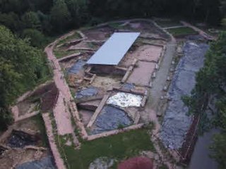
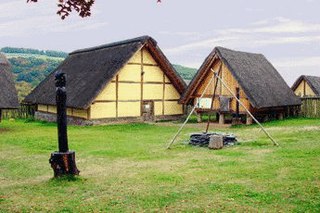
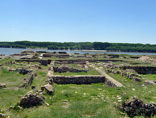
Wareswald is an archaeological site comprising the remains of a Roman vicus in the district of Sankt Wendel in Saarland, Germany.
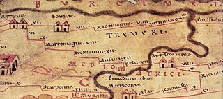
The Roman road from Trier to Cologne is part of the Via Agrippa, a Roman era long distance road network, that began at Lyon. The section from Augusta Treverorum (Trier) to the CCAA (Cologne), the capital of the Roman province of Germania Inferior, had a length of 66 Roman leagues. It is described in the Itinerarium Antonini, the itinerarium by Emperor Caracalla (198–217), which was revised in the 3rd century, and portrayed in the Tabula Peutingeriana or Peutinger Table, the Roman map of the world discovered in the 16th century, which shows the Roman road network of the 4th century.

The Castra Alteium is a former late-Roman border fort on the Danube-Iller-Rhine Limes (DIRL). It is located in the territory of the city of Alzey in Rhenish Hesse, Germany. The fort was presumably built in the course of the last reconstruction measures on the Rhine frontier between 367 and 370 AD under the western Emperor Valentinian I. Previously, there was a Roman civilian settlement (Vicus), Altiaia, which was devastated by Alamanni in 352–353. The fort was also destroyed twice, and probably abandoned at the end of the fifth century.
Contiomagus was a Gallo-Roman vicus in the Roman province of Gallia Belgica. The location today is the site of the district of Pachten in the municipality of Dillingen, Saarland.


