
South Kingstown is a town in, and the county seat of, Washington County, Rhode Island, United States. The population was 31,931 at the 2020 census. South Kingstown is the second largest town in Rhode Island by total geographic area, behind New Shoreham, and the third largest town in Rhode Island by geographic land area, behind Exeter and Coventry.

USS Dale was a sloop-of-war in the United States Navy commissioned on 11 December 1839. Dale was involved in the Mexican–American War, the American Civil War, operations along Africa to suppress slave trade, and was used by the U.S. Revenue Cutter Service and later the U.S. Coast Guard, among other activities. Dale was placed into ordinary numerous times.

The third USS Dale (DD-290) was a Clemson-class destroyer in the United States Navy. She was named for Richard Dale.

Herman Edward Daly was an American ecological and Georgist economist and professor at the School of Public Policy of University of Maryland, College Park in the United States, best known for his time as a senior economist at the World Bank from 1988 to 1994. In 1996, he was awarded the Right Livelihood Award for "defining a path of ecological economics that integrates the key elements of ethics, quality of life, environment and community."

The Dale Hollow Reservoir is a reservoir situated on the Kentucky/Tennessee border. The lake is formed by the damming of the Obey River, 7.3 miles (11.7 km) above its juncture with the Cumberland River at river mile 380. Portions of the lake also cover the Wolf River. Dale Hollow is one of four major flood control reservoirs for the Cumberland; the others being Percy Priest Lake, Lake Cumberland, and Center Hill Lake. It is also the site of Dale Hollow Lake State Park on the north (Kentucky) side.

USS Daly (DD-519), a Fletcher-class destroyer, was a ship of the United States Navy named for Marine Sergeant Major Daniel Daly, (1873–1937), one of the very few people to be twice awarded the Medal of Honor.
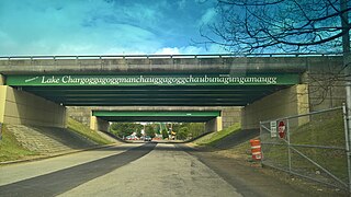
Lake Chaubunagungamaug, also known as Webster Lake, is a lake in the town of Webster, Massachusetts. It is located near the Connecticut border and has a surface area of 1,442 acres. Since 1921, the lake has also been known by a much longer name having 45 letters comprising fourteen syllables: Lake Chargoggagoggmanchauggagoggchaubunagungamaugg. The lake has become famous beyond Central Massachusetts for having the longest name of any geographic feature in all of the United States.

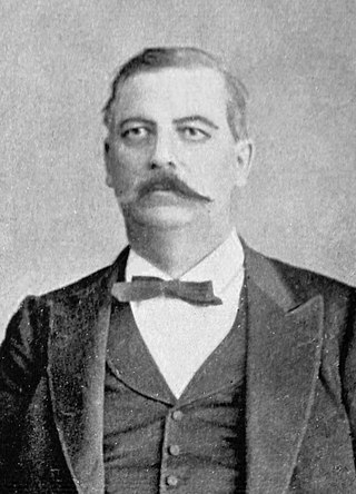
Porter Hinman Dale was an American educator, lawyer, and politician who served as a member of both the United States House of Representatives from 1915 to 1923, and the United States Senate from Vermont from 1923 to 1933.

The 180th meridian or antimeridian is the meridian 180° both east and west of the prime meridian in a geographical coordinate system. The longitude at this line can be given as either east or west.
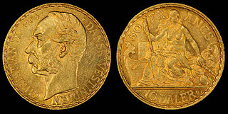
The daler was the currency of the Danish West Indies between 1849 and 1917, and of the United States Virgin Islands between 1917 and 1934.

USS Edward C. Daly (DE-17) was an Evarts-class "short-hull" destroyer escort in the service of the United States Navy.
Dale is an unincorporated community and census-designated place located on State Highway 270 in Pottawatomie County, Oklahoma, United States. It lies in the North Canadian River bottom, a few miles northwest of Shawnee. The population was 175 at the time of the 2020 Census, a slight decrease over the 2010 census figure of 186.

Pearl Harbor is an American lagoon harbor on the island of Oahu, Hawaii, west of Honolulu. It was often visited by the Naval fleet of the United States, before it was acquired from the Hawaiian Kingdom by the U.S. with the signing of the Reciprocity Treaty of 1875. Much of the harbor and surrounding lands are now a United States Navy deep-water naval base. It is also the headquarters of the United States Pacific Fleet. The U.S. government first obtained exclusive use of the inlet and the right to maintain a repair and coaling station for ships here in 1887. The surprise attack by the Imperial Japanese Navy on December 7, 1941, led the United States to declare war on the Empire of Japan, making the attack on Pearl Harbor the immediate cause of the United States' entry into World War II.

The 2010 congressional elections in Rhode Island were held on November 2, 2010, and determined who would represent Rhode Island in the United States House of Representatives. Representatives are elected for two-year terms; the elected served in the 112th Congress from January 3, 2011, until January 3, 2013.

Edward William Hanson was a United States Navy Vice admiral and the governor of American Samoa from June 26, 1938, to July 30, 1940. As Governor of American Samoa, Hanson believed that the native Samoans had a good way of life, and did little to interfere with established practices on the islands.
Kirton Island is a small coastal island of the Robinson Group, lying 6 kilometres (3 nmi) west of Cape Daly, Mac. Robertson Land, Antarctica, and about 3 kilometres (1.5 nmi) south of Macklin Island. It was mapped by Norwegian cartographers from air photos taken by the Lars Christensen Expedition, 1936–37, and was named by the Antarctic Names Committee of Australia for M. Kirton, a geophysicist at Mawson Station in 1959.
Macklin Island is a small island in the eastern part of the Robinson Group, about 3 kilometres (1.5 nmi) north of Kirton Island, and 6 kilometres (3 nmi) northwest of Cape Daly, Mac. Robertson Land, Antarctica. It was mapped by Norwegian cartographers from air photos taken by the Lars Christensen Expedition, 1936–37, and was named by the Antarctic Names Committee of Australia for E.L. Macklin, a radio officer at Mawson Station in 1955 and 1959.
The Church of Our Lady of Good Counsel is a Roman Catholic parish church in the Roman Catholic Archdiocese of New York, located at 10 Austin Place, Staten Island, New York City.
George N. Dale was a Vermont lawyer and politician who served as the 28th lieutenant governor of Vermont from 1870 to 1872. He was the father of Porter Hinman Dale, who served as a member of the United States House of Representatives and as a United States Senator.
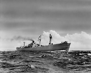
SS Marcus Daly was a liberty ship built by the Kaiser Shipyards at their Permanente No.1 yard at Richmond, California, and launched on 24 July 1943.
