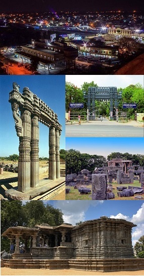
Warangal is a city in the Indian state of Telangana and the district headquarters of Warangal district. It is the second largest city in Telangana with a population of 811,844 per 2011 Census of India, and spreading over an 406 km2 (157 sq mi). Warangal served as the capital of the Kakatiya dynasty which was established in 1163. The monuments left by the Kakatiyas include fortresses, lakes, temples and stone gateways which, in the present, helped the city to become a popular tourist attraction. The Kakatiya Kala Thoranam was included in the emblem of Telangana by the state government and Warangal is also touted as the cultural capital of Telangana.

Dharmasagar is a Town and a mandal in Hanamkonda district in Telangana, India. Dharmasagar is well connected with towns like Kazipet, and Hanamakonda by road. It is 14.4 km far from its District Main Town Warangal and 122 km far from its State Capital Hyderabad.

Karimnagar district is one of the 33 districts of the Indian state of Telangana. Karimnagar city is its administrative headquarters. The district shares boundaries with Peddapalli, Jagityal, Sircilla, Siddipet, Jangaon, Hanamkonda district and Jayashankar Bhupalapally districts.

Hanamkonda district, is a district in the Indian state of Telangana. The district headquarters are located at Hanamakonda. The district borders the districts of Jangaon, Karimnagar, Warangal, Bhupalpally and Siddipet.

Kazipet is the major educational and transport hub in Hanumakonda district in the Indian state of Telangana. It is a city in Warangal Tri-City, and a mandal in Hanamakonda district. Kazipet falls under Greater Warangal Municipal Corporation.
Jangaon (Janagama) is a city and the district headquarters of Jangaon district in the Indian state of Telangana. It is also the mandal and divisional headquarters of Jangaon Mandal and Jangaon revenue division respectively. It is about 85 kilometres (53 mi) from the state capital Hyderabad. It lies on the National Highway 163.
Govindaraopet is a village and a mandal in Mulugu District in the state of Telangana in India. It is located approximately 70 km (43 mi) distance from Hanamkonda along National Highway-163 which connects Hyderabad in Telangana and Bhopalapatnam in Chhattisgarh. And it is 200 km (120 mi) distance from its state capital Hyderabad.
Shayampet is a village and a mandal in Hanamkonda district in the state of Telangana in India.
Atmakur is a village and mandal in Hanamkonda district from the state of Telangana in India.
Parkal is a town in Hanumakonda district of the Indian state of Telangana.
Wardhanapet Assembly constituency is a Scheduled Caste reserved constituency in Warangal district and Hanamkonda district of Telangana that elects representatives to the Telangana Legislative Assembly in India. It is one of the seven assembly segments of the Warangal Lok Sabha constituency.
Panthini is a village in Inavole mandal, Hanamkonda district in the state of Telangana in India. It is located to the south of the city of Warangal, and north of the village of Wardhannapet, alongside Warangal-Khammam Road.
Paidipally is a village in the Hanamkonda district of Telangana state in India. It is located in outskirts of Warangal City. Paidipally is located in the semi-arid region of Telangana. Paidipally is the part of the Greater Warangal Municipal Corporation as 3rd division It has a population of 12105 as per 2011 census and is in Parkal mandal.
Narsakkapalli is a village in Parkal mandal of Hanamkonda district in Telangana state, India. It is situated 4 kilometres (2.5 mi) away from Parkal on the bypass road to Kamalapur.
Dandepalle or Dandepally is a village in Elkathurthy mandal, Hanamkonda district, in the Indian state of Telangana. Prior to the creation of Telangana in 2014, the village was a part of Karimnagar district, Andhra Pradesh.
Warangal mandal is one of the 13 mandals in Warangal district in of the Indian state of Telangana. It is under the administration of Warangal revenue division and has its headquarters at Warangal. The mandal is bounded by Hanamkonda and Hasanparthy mandals.

Warangal district, formerly Warangal Rural district, is a district in the Indian state of Telangana. The district shares boundaries with Mahabubabad, Jangaon, Hanamkonda, Mulugu and Bhupalpally districts.

Jayashankar Bhupalpally district is a district in the Indian state of Telangana. The district headquarters are located at Bhupalpally. It was a part of the erstwhile Warangal district and Karimnagar district prior to the re-organisation of districts in the state. The district share boundaries with Karimnagar, Mancherial, Peddapalli, Hanamkonda, Warangal, and Mulugu districts and with the state boundary of Maharashtra and Chhattisgarh. The world's largest multi-stage lift irrigation project Kaleshwaram Lift Irrigation Project is in Jayashankar Bhupalpally District and Jayashankar Bhupalpally District falls Under naxal affected district as per Red corridor.

Janagama district is a district in the middle of the Indian state of Telangana. It was a part of the erstwhile Warangal district prior to the re-organisation of districts in the state. The district shares boundaries with Suryapet, Yadadri, Warangal, Hanamkonda, Siddipet and Mahabubabad districts.
Paluvelupula is a village in Hanamkonda mandal, Hanamkonda district, Telangana.


