

The Dana Meadows can be found at the eastern entrance to Yosemite National Park, at the foot of Mount Dana, not far from Tuolumne Meadows and the Tioga Pass entrance station.
The Dana Meadows can be found at the eastern entrance to Yosemite National Park, at the foot of Mount Dana, not far from Tuolumne Meadows and the Tioga Pass entrance station.
The Dana Fork of the Tuolumne River originates adjacent to the meadows, and flows west through them towards its junction with the Lyell Fork of the Tuolumne River.
At an altitude of 9,728 feet (2,965 m), [1] the meadow can be covered in snow up to 162 inches (411 cm) deep in wintertime. [2] In June or July, it is springtime in these meadows, but snow can come at any time, especially after 1 September.
Before Yosemite became a park, Basque sheepherders would graze their flocks here, and in other areas of the Sierra Nevada. Often lonely, they would carve their initials into the trees of the meadow, several of which are still visible. (In hunting season, some animals of the Sierra, such as the deer, have learned to migrate into the park.)
The meadows are named for James Dwight Dana (1813–1895), a professor of geology and natural history at Yale. [3]

Yosemite National Park is a national park of the United States in California. It is bordered on the southeast by Sierra National Forest and on the northwest by Stanislaus National Forest. The park is managed by the National Park Service and covers 759,620 acres in four counties – centered in Tuolumne and Mariposa, extending north and east to Mono and south to Madera. Designated a World Heritage Site in 1984, Yosemite is internationally recognized for its granite cliffs, waterfalls, clear streams, groves of giant sequoia, lakes, mountains, meadows, glaciers, and biological diversity. Almost 95 percent of the park is designated wilderness. Yosemite is one of the largest and least fragmented habitat blocks in the Sierra Nevada.

The John Muir Trail (JMT) is a long-distance trail in the Sierra Nevada mountain range of California, passing through Yosemite, Kings Canyon and Sequoia National Parks. It is named after John Muir, a naturalist.

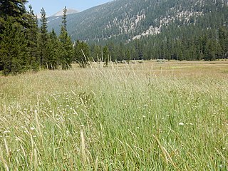
Tuolumne Meadows is a gentle, dome-studded, sub-alpine meadow area along the Tuolumne River in the eastern section of Yosemite National Park in the United States. Its approximate location is 37°52.5′N119°21′W. Its approximate elevation is 8,619 feet (2,627 m). The term Tuolumne Meadows is also often used to describe a large portion of the Yosemite high country around the meadows, especially in context of rock climbing.

The Merced River, in the central part of the U.S. state of California, is a 145-mile (233 km)-long tributary of the San Joaquin River flowing from the Sierra Nevada into the San Joaquin Valley. It is most well known for its swift and steep course through the southern part of Yosemite National Park, where it is the primary watercourse flowing through Yosemite Valley. The river's character changes dramatically once it reaches the plains of the agricultural San Joaquin Valley, where it becomes a slow-moving meandering stream.

The Tuolumne River flows for 149 miles (240 km) through Central California, from the high Sierra Nevada to join the San Joaquin River in the Central Valley. Originating at over 8,000 feet (2,400 m) above sea level in Yosemite National Park, the Tuolumne drains a rugged watershed of 1,958 square miles (5,070 km2), carving a series of canyons through the western slope of the Sierra. While the upper Tuolumne is a fast-flowing mountain stream, the lower river crosses a broad, fertile and extensively cultivated alluvial plain. Like most other central California rivers, the Tuolumne is dammed multiple times for irrigation and the generation of hydroelectricity.

Lembert Dome is a granite dome rock formation in Yosemite National Park in the US state of California. The dome soars 800 feet (240 m) above Tuolumne Meadows and the Tuolumne River and can be hiked starting at the Tioga Road in the heart of Tuolumne Meadows, 8 miles (13 km) west of the Tioga Pass Entrance to Yosemite National Park. The landform is an example of a rôche moutonnée with clear lee and stoss slopes.

Tioga Pass is a mountain pass in the Sierra Nevada mountain range of California. State Route 120 runs through it, and serves as the eastern entry point for Yosemite National Park, at the Tioga Pass Entrance Station. It is the highest elevation highway pass in California and in the Sierra Nevada at an elevation of 9,945 ft (3,031 m). Mount Dana is to the east of the pass, and Gaylor Peak to the west.

Mount Lyell is the highest point in Yosemite National Park, at 13,114 feet (3,997 m). It is located at the southeast end of the Cathedral Range, 1+1⁄4 miles northwest of Rodgers Peak. The peak as well as nearby Lyell Canyon is named after Charles Lyell, a well-known 19th century geologist. The peak had one of the last remaining glaciers in Yosemite, Lyell Glacier. The Lyell Glacier is currently considered to be a permanent ice field, not a living glacier. Mount Lyell divides the Tuolumne River watershed to the north, the Merced to the west, and the Rush Creek drainage in the Mono Lake Basin to the southeast.
Mount Ansel Adams is a peak in the Sierra Nevada of California with an elevation of 11,766 ft. The summit is in Yosemite National Park near the park's eastern boundary. It lies 0.8 miles (1.3 km) northeast of Foerster Peak and 1.3 miles (2.1 km) west-southwest of Electra Peak at the head of the Lyell Fork of the Merced River. It was named in 1985 for Ansel Adams, the preeminent landscape photographer, conservationist, and member of the board of directors of the Sierra Club, a role he maintained for 37 years.
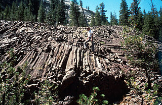
Little Devils Postpile is a columnar basalt rock formation in the Sierra Nevada, located within Yosemite National Park and eastern Tuolumne County, California.

Cherry Creek is a large, swift-flowing stream in the Sierra Nevada mountain range, and is the largest tributary of the Tuolumne River. The creek is 44.6 miles (71.8 km) long measured to its farthest headwaters; the main stem itself is 27.7 miles (44.6 km) long, draining a watershed of 234 square miles (610 km2) in the Stanislaus National Forest. Part of the drainage also extends into the northwest corner of Yosemite National Park.

Little Yosemite Valley is a smaller glacial valley upstream in the Merced River drainage from the Yosemite Valley in Yosemite National Park. The Merced River meanders through the 3.5 mi (5.6 km) long flat valley, draining out over Nevada Fall and Vernal Fall before emptying into the main Yosemite Valley. It can be reached by a day hike from the main valley, and is the most popular area in the Yosemite Wilderness. The Valley provides access to nearby destinations such as the back side of Half Dome, Clouds Rest and the High Sierra Camp at Merced Lake.

Mount Maclure is the nearest neighbor to Mount Lyell, the highest point in Yosemite National Park. Mount Maclure is the fifth-highest mountain of Yosemite. Mount Maclure is located at the southeast end of the Cathedral Range, about 0.6 miles (0.97 km) northwest of Lyell. The summit is on the boundary between Madera and Tuolumne counties which is also the boundary between the park and the Ansel Adams Wilderness. It was named in honor of William Maclure, a pioneer in American geology who produced the first geological maps of the United States. Maclure Glacier, one of the last remaining glaciers in Yosemite, is situated on the mountain's northern flank.

Yosemite Creek is a 15-mile-long (24 km) creek of the Sierra Nevada, located in Yosemite National Park, Mariposa County, California, United States.

Yosemite National Park is located in the central Sierra Nevada of California. Three wilderness areas are adjacent to Yosemite: the Ansel Adams Wilderness to the southeast, the Hoover Wilderness to the northeast, and the Emigrant Wilderness to the north.
Colby Mountain is a summit in Tuolumne County, California. With an elevation of 9,639 feet (2,938 m), Colby Mountain is the 644th highest summit in the state of California.
Hiking, rock climbing, and mountain climbing around Tuolumne Meadows in Yosemite National Park has many options.
Lyell Meadow is a meadow, in the region of Tuolumne Meadows, in Yosemite National Park.

Gaylor Peak is an 11,004-foot-elevation (3,354 meter) mountain summit located on the crest of the Sierra Nevada mountain range in northern California, United States. The peak is situated on the common boundary shared by Yosemite National Park with Inyo National Forest, as well as the border shared by Mono County with Tuolumne County. It rises immediately above the park's Tioga Pass entrance station and Tioga Lake. Topographic relief is significant as the summit rises approximately 1,400 feet above the lake in one-half mile (0.80 km). The peak is a popular hiking destination on summer weekends due to easy access via the two-mile Gaylor Lakes Trail from State Route 120 which traverses the east base of the peak.
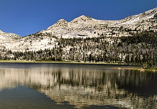
Rafferty Peak is an 11,110-foot-elevation mountain summit located in Yosemite National Park, in California, United States. It is situated on the common border shared by Mariposa and Tuolumne Counties. It is set south of Tuolumne Meadows in the Cathedral Range which is a sub-range of the Sierra Nevada mountain range. The mountain rises one mile (1.6 km) northwest of Tuolumne Pass, 1.4 mile south of Johnson Peak, and 2.5 miles east of Matthes Crest. Tuolumne Pass is the low point of the saddle between Rafferty Peak and Fletcher Peak. Topographic relief is significant as the summit rises 1,500 feet above Nelson Lake in one mile.
37°53′37″N119°15′19″W / 37.8935376°N 119.2551516°W
| | This Yosemite-related article is a stub. You can help Wikipedia by expanding it. |