Leyte is an island in the Visayas group of islands in the Philippines. It is eighth-largest and sixth-most populous island in the Philippines, with a total population of 2,626,970 as of 2020 census.
Danao, officially the Municipality of Danao, is a 4th class municipality in the province of Bohol, Philippines. According to the 2020 census, it has a population of 20,245 people.

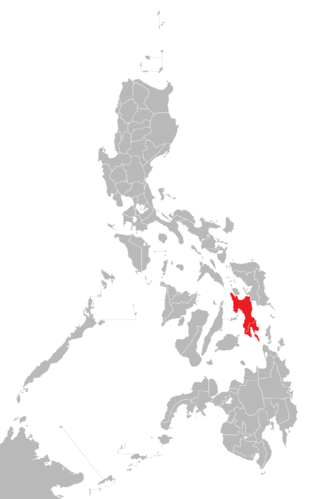
Concepcion, officially the Municipality of Concepcion, is a 6th class municipality in the province of Romblon, Philippines. The municipality is coextensive with Maestre de Campo Island, which is also known as Sibale Island. According to the 2020 census, it has a population of 3,561 people, making it the least populated town in the province.

Typhoon Chanchu, known in the Philippines as Typhoon Caloy, was the most intense typhoon in the South China Sea in the month of May according to the Hong Kong Observatory (HKO). The first named storm of the 2006 Pacific typhoon season, Chanchu formed on May 8 in the vicinity of the Federated States of Micronesia and progressed westward. It gradually intensified into a tropical storm and later severe tropical storm before moving through the Philippines. On May 13, Chanchu entered the South China Sea and became a typhoon, according to the Japan Meteorological Agency (JMA). Warm waters and favorable outflow allowed the storm to quickly intensify to peak maximum sustained winds of 175 km/h (109 mph) on May 15. Around that time, the typhoon turned sharply to the north toward southeastern China. Chanchu weakened as it curved to the northeast, making landfall near Shantou, Guangdong on May 17 as a severe tropical storm. The government of China considered Chanchu the earliest typhoon to make landfall in the province. On the next day, the storm emerged into the East China Sea, becoming extratropical on May 19 before dissipating west of Kyushu.

Typhoon Utor, known in the Philippines as Typhoon Seniang, swept through the central Philippines in December 2006, exacerbating the damage left behind by previous Philippine typhoon strikes that year. Residual moisture from the tropical cyclone indirectly contributed to extensive flooding in Malaysia. Utor originated from an area of disturbed weather that organized into a tropical depression on December 7 west-southwest of Yap. The cyclone steadily progressed westward while gradually intensifying, reaching tropical storm intensity late on December 7. On December 9 and the ensuing two days, Utor crossed the central Philippines and reached typhoon strength before weakening somewhat upon entry into the South China Sea. Reintensification ensued afterwards, and Utor reached its peak intensity on December 13 with maximum sustained winds of 155 km/h (100 mph) shortly after regaining typhoon strength. However, wind shear and dry air began to take its toll on Utor thereafter, quickly weakening the storm until its dissipation on December 15.

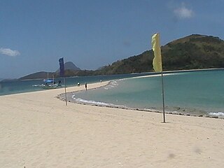
Igbon Island is an island and barangay in northeastern Iloilo, Philippines. It is part of the municipality of Concepcion. According to the 2010 census, it has a population of 2,547. The island is moderately known in the Philippines for its scuba diving.

Pan de Azucar, variously known as Tampisaw Island or Tambaliza, is a populated island in the Visayan Sea in the Philippines. The island is known for MountPan de Azucar a steep volcanic cone and a prominent landmark at the northern entrance of Guimaras Strait.

Islas de Gigantes is an island chain within the larger Western Visayas archipelago in the Visayan Sea. It is part of the municipality of Carles, Iloilo, Philippines, and the northernmost part of Iloilo province. The Gigantes islands consist of about ten islands; the two largest are Gigantes Norte and Gigantes Sur. According to the 2020 census, it has a population of 14,332 residents. There is also a lighthouse on Gigantes Norte.
Bayas Island is a small island and barangay in northeastern Iloilo, Philippines. It is part of the municipality of Estancia. According to the 2020 census, it has a population of 2,616. The Island was titled to Filomena Reyes Aclaro and is now shared to the locals.
The Concepcion Islands are 17 variously inhabited and uninhabited islands in northeastern Iloilo, Philippines. The islands are politically subdivided into 11 island barangays and are part of the municipality of Concepcion. According to the 2010 census, the islands collectively have a population of 19,080, 48 percent the total population of Concepcion.
Botlog Island is an island and barangay in northeastern Iloilo, Philippines. It is part of the municipality of Concepcion. According to the 2010 census, it has a population of 441.
Malangabang is an island and barangay in northeastern Iloilo, Philippines. It is part of the municipality of Concepcion. According to the 2010 census, it has a population of 2,925. Fishing is the main source of income for the island's residents.The Owner is Honorato Ciriaco.
Bulubadiangan Island is a privately owned island in northeastern Iloilo, Philippines. It is part of barangay Polopińa, Concepcion. The Sandbar Island Beach Resort on Bulubadiangan is moderately known within the Philippines.
Baliguian Island is an inhabited island in northeastern Iloilo, Philippines. It is the westernmost of the Concepcion Islands and politically administered by the municipality of Concepcion. A virtually flat island, Baliguian features a lighthouse to aid in ship navigation.
Bocot Island is a small island in northeastern Iloilo, Philippines. It is part of the municipality of Concepcion.
Magalumbi is an island in northeastern Iloilo, Philippines. It is part of the municipality of Batad, although the official provincial government website lists it as an offshore island of Estancia. Magalumbi is part of barangay Tanao, which has a population of 1,903 according to the 2010 census.
Nabunot is an island in northeastern Iloilo, Philippines. It is one of fourteen islands politically administered by the municipality of Carles.
Manlot is an island-barangay in northeastern Iloilo, Philippines. It is one of fourteen islands politically administered by the municipality of Carles.
Calagnaan is an island in northeastern Iloilo, Philippines. It is one of fourteen islands politically administered by the municipality of Carles. The population of the island is 5,017 as of 2020 census.
Binuluangan is an inhabited island-barangay in northeastern Iloilo, Philippines. It is one of fourteen islands politically administered by the municipality of Carles. In 2010 it had a population of 1,682. There is an elementary school on the island.
