
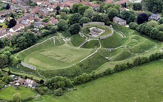
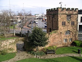
The Dane John Mound, also known as the Dane John Gardens, is a former Roman cemetery in the city of Canterbury, Kent. It was converted into a motte-and-bailey castle in the 11th century, and turned into a civic park between 1790 and 1803.
The Dane John Mound, also known as the Dane John Gardens, is a former Roman cemetery in the city of Canterbury, Kent. It was converted into a motte-and-bailey castle in the 11th century, and turned into a civic park between 1790 and 1803.
The first construction on the Dane John site was a burial mound, built during the Roman occupation of Canterbury between the 1st and 4th centuries AD. [1] In 1066, Canterbury was occupied by the Normans. [2] William the Conqueror instructed that a castle was to be built in the city; it was built on the south side of the city using the Dane John mound and formed part of the circuit of defence, with property being destroyed to make room for it. [3] This timber motte and bailey castle was later abandoned and the second Canterbury Castle was built just to the north in 1123. [4]
The Dane John Gardens were built between 1790 and 1803 by alderman James Simmons, in the south-east corner of the walls, remodelling the old castle motte, and incorporating the Roman bank and the medieval wall-walk into the design, [5] although their design was later accredited to William Masters, the Canterbury nurseryman. [6] The ownership of the land was disputed, and the park was taken into the control of the city shortly after its construction. [7]
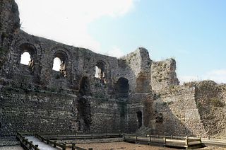
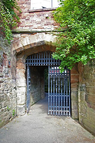
During the Second World War, part of the city walls near the Dane John Gardens were turned into an ammunition depot, dug into the bank of the wall. [7] The gardens are Grade II listed on the Register of Historic Parks and Gardens. [8] The monument atop the mound and the sundial are each Grade II listed on the National Heritage List for England. [9] [10]
A motte-and-bailey castle is a European fortification with a wooden or stone keep situated on a raised area of ground called a motte, accompanied by a walled courtyard, or bailey, surrounded by a protective ditch and palisade. Relatively easy to build with unskilled labour, but still militarily formidable, these castles were built across northern Europe from the 10th century onwards, spreading from Normandy and Anjou in France, into the Holy Roman Empire, as well as the Low Countries it controlled, in the 11th century, when these castles were popularized in the area that became the Netherlands. The Normans introduced the design into England and Wales. Motte-and-bailey castles were adopted in Scotland, Ireland, and Denmark in the 12th and 13th centuries. By the end of the 13th century, the design was largely superseded by alternative forms of fortification, but the earthworks remain a prominent feature in many countries.
Canterbury Castle is a Norman Castle in Canterbury, Kent, England. It is a five-minute walk from Canterbury East Station and the main bus station around City Wall.
Castle Acre Castle and town walls are a set of ruined medieval defences built in the village of Castle Acre, Norfolk. The castle was built soon after the Norman Conquest by William de Warenne, the Earl of Surrey, at the intersection of the River Nar and the Peddars Way. William constructed a motte-and-bailey castle during the 1070s, protected by large earthwork ramparts, with a large country house in the centre of the motte. Soon after, a small community of Cluniac monks were given the castle's chapel in the outer bailey; under William, the second earl, the order was given land and estates to establish Castle Acre Priory alongside the castle. A deer park was created nearby for hunting.

Launceston Castle is located in the town of Launceston, Cornwall, England. It was probably built by Robert the Count of Mortain after 1068, and initially comprised an earthwork and timber castle with a large motte in one corner. Launceston Castle formed the administrative centre of the new earldom of Cornwall, with a large community packed within the walls of its bailey. It was rebuilt in stone in the 12th century and then substantially redeveloped by Richard of Cornwall after 1227, including a high tower to enable visitors to view his surrounding lands. When Richard's son, Edmund, inherited the castle, he moved the earldom's administration to Lostwithiel, triggering the castle's decline. By 1337, the castle was increasingly ruinous and used primarily as a gaol and to host judicial assizes.

The Cow Tower is an artillery tower by the River Wensum in Norwich, Norfolk, England. Built between 1398 and 1399 by the city authorities in response to the threat from France and indigenous English rebels, the tower was intended to defend the north-eastern approach to Norwich with hand cannons and bombards. It stood apart from the main city walls, close to the river where its height would have allowed it to fire onto the higher ground opposite the city. The tower was designed to hold a garrison when required and was well furnished, probably using different floors for dining and sleeping.

Castle Batch was a fortification at Worle that once stood overlooking the town of Weston-super-Mare in Somerset, England.
Down End Castle, also known as Downend Castle, Chisley Mount or Chidley Mount, was a motte-and-bailey castle at Down End, north of Dunball in the parish of Puriton, Somerset, England. It has been designated as a Scheduled Ancient Monument.

Conwy's town walls are a medieval defensive structure around the town of Conwy in Wales. The walls were constructed between 1283 and 1287 after the foundation of Conwy by Edward I, and were designed to form an integrated system of defence alongside Conwy Castle. The walls are 1.3 km (0.81 mi) long and include 21 towers and three gatehouses. The project was completed using large quantities of labourers brought in from England; the cost of building the castle and walls together came to around £15,000, a huge sum for the period. The walls were slightly damaged during the rebellion of Owain Glyndŵr in 1401, but political changes in the 16th century reduced the need to maintain such defences around the town. The fortifications were treated sympathetically during the development of the road and railway systems in Conwy during the 19th century and survived largely intact into the modern period. Today the walls form part of the UNESCO World Heritage Site administered by Cadw. Historians Oliver Creighton and Robert Higham describe the defences as "one of the most impressive walled circuits" in Europe.

Caernarfon's town walls are a medieval defensive structure around the town of Caernarfon in North Wales. The walls were constructed between 1283 and 1292 after the foundation of Caernarfon by Edward I, alongside the adjacent castle. The walls are 734 m (2,408 ft) long and include eight towers and two medieval gatehouses. The project was completed using large numbers of labourers brought in from England; the cost of building the walls came to around £3,500, a large sum for the period. The walls were significantly damaged during the rebellion of Madog ap Llywelyn in 1294, and had to be repaired at considerable expense. Political changes in the 16th century reduced the need to maintain such defences around the town. Today the walls form part of the UNESCO World Heritage Site administered by Cadw. Archaeologists Oliver Creighton and Robert Higham describe the defences as "a remarkably intact walled circuit".
Worcester's city walls are a sequence of defensive structures built around the city of Worcester in England between the 1st and 17th centuries. The first walls to be built around Worcester were constructed by the Romans. These early walls lasted beyond the fall of the Empire, and the defences encouraged several early Christian foundations to establish themselves in Worcester during the troubled 6th and 7th centuries. The Anglo-Saxons expanded Worcester in the 890s, forming a new walled, planned city, called a burh. The burh utilised the southern stretches of the old Roman walls, but pushed further north to enclose a much larger area. The Anglo-Saxon city walls were maintained by a share of taxes on a local market and streets, in an agreement reinforced by a royal charter.
Coventry's city walls are a sequence of defensive structures built around the city of Coventry in England.

Bath's city walls were a sequence of defensive structures built around the city of Bath in England. Roman in origin, then restored by the Anglo-Saxons, and later strengthened in the High medieval period, the walls formed a complete circuit, covering the historic core of the modern city, an area of approximately 23 acres (9.3 ha) including the Roman Baths and medieval Bath Abbey. In the mid 18th century most of the town walls and gatehouses were demolished to accommodate the Georgian development of the town. However, the line of the walls can still be traced in the town's street layout.

Abergavenny's town walls are a sequence of defensive walls built around the town of Abergavenny in Monmouthshire, Wales.

Alnwick's town walls are a 15th-century defensive structure built around the town of Alnwick in England.

Berwick's town walls are a sequence of defensive structures built around the town of Berwick-upon-Tweed in England.

Beverley's town walls are a sequence of defensive structures built around the town of Beverley in the East Riding of Yorkshire, England.

Southampton's town walls are a sequence of defensive structures built around the town in southern England. Although earlier Roman and Anglo-Saxon settlements around Southampton had been fortified with walls or ditches, the later walls originate with the move of the town to the current site in the 10th century. This new town was defended by banks, ditches and the natural curve of the river and coastline. The Normans built a castle in Southampton but made no attempts to improve the wider defences of the town until the early 13th century, when Southampton's growing prosperity as a trading centre and conflict with France encouraged the construction of a number of gatehouses and stone walls to the north and east sides of the settlement.

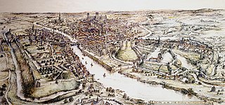
Canterbury city walls are a sequence of defensive walls built around the city of Canterbury in Kent, England. The first city walls were built by the Romans, probably between 270 and 280 AD. These walls were constructed from stone on top of an earth bank, and protected by a ditch and wall towers. At least five gates were placed into the walls, linked to the network of Roman roads across the region. With the collapse of Roman Britain, Canterbury went into decline but the walls remained, and may have influenced the decision of Augustine to settle in the city at the end of the 6th century. The Anglo-Saxons retained the defensive walls, building chapels over most of the gates and using them to defend Canterbury against Viking incursions.