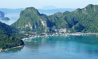
Palawan, officially the Province of Palawan, is an archipelagic province of the Philippines that is located in the region of Mimaropa. It is the largest province in the country in terms of total area of 14,649.73 km2 (5,656.29 sq mi). The capital city is Puerto Princesa. Palawan is known as the Philippines' Last Frontier and as the Philippines' Best Island.

The Philippine Sea is a marginal sea of the Western Pacific Ocean east of the Philippine archipelago, the largest in the world, occupying an estimated surface area of 5 million square kilometers. The Philippine Sea Plate forms the floor of the sea. Its western border is the first island chain to the west, comprising the Ryukyu Islands in the northwest and Taiwan in the west. Its southwestern border comprises the Philippine islands of Luzon, Catanduanes, Samar, Leyte, and Mindanao. Its northern border comprises the Japanese islands of Honshu, Shikoku and Kyūshū. Its eastern border is the second island chain to the east, comprising the Bonin Islands and Iwo Jima in the northeast, the Mariana Islands in the due east, and Halmahera, Palau, Yap and Ulithi in the southeast. Its southern border is Indonesia's Morotai Island.
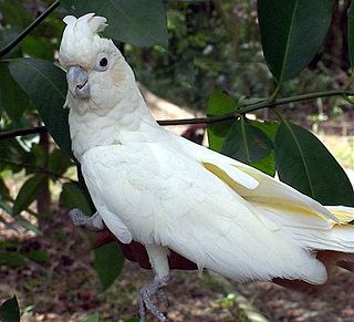
The red-vented cockatoo, also known as the Philippine cockatoo and locally katala, abukay, agay or kalangay, is a species of cockatoo. It is endemic to the Philippines though pressured by various environmental degradation and illegal pet trades, the population of the Philippine cockatoo is somehow growing owing to Katala Organization.It is roughly the size and shape of the Tanimbar corella, but is easily distinguished by the red feathers around the vent. It is threatened by habitat loss and the cage-bird trade.

Southeast Asian coral reefs have the highest levels of biodiversity for the world's marine ecosystems. They serve many functions, such as forming the livelihood for subsistence fishermen and even function as jewelry and construction materials. Corals inhabit coastal waters off of every continent except Antarctica, with an abundance of reefs residing along Southeast Asian coastline in several countries including Indonesia, the Philippines, and Thailand. Coral reefs are developed by the carbonate-based skeletons of a variety of animals and algae. Slowly and overtime, the reefs build up to the surface in oceans. Coral reefs are found in shallow, warm salt water. The sunlight filters through clear water and allows microscopic organisms to live and reproduce. Coral reefs are actually composed of tiny, fragile animals known as coral polyps. Coral reefs are significantly important because of the biodiversity. Although the number of fish are decreasing, the remaining coral reefs contain more unique sea creatures. The variety of species living on a coral reef is greater than anywhere else in the world. An estimation of 70-90% of fish caught are dependent on coral reefs in Southeast Asia and reefs support over 25% of all known marine species. However, those sensitive coral reefs are facing detrimental effects on them due to variety of factors: overfishing, sedimentation and pollution, bleaching, and even tourist-related damage.

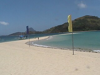
Cagayancillo, officially the Municipality of Cagayancillo, is a 6th class municipality in the province of Palawan, Philippines. According to the 2020 census, it has a population of 6,884 people.

The Tubbataha Natural Park, also known as the Tubbataha Reefs Natural Park, is a protected area of the Philippines located in the middle of the Sulu Sea. The marine and bird sanctuary consists of two huge atolls and the smaller Jessie Beazley Reef covering a total area of 97,030 hectares. It is located 150 kilometres (93 mi) southeast of Puerto Princesa, the capital of Palawan. The uninhabited islands and reefs are part of the island municipality of Cagayancillo, located roughly 130 kilometers (81 mi) to the northeast of the reef.
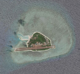
Thitu Island, also known as Pag-asa Island (Tagalog: Pulo ng Pag-asa; Pangasinan: Ilalo, having an area of 37.2 hectares, is the second largest of the naturally occurring Spratly Islands and the largest of the Philippine-administered islands. It lies about 480 kilometres west of Puerto Princesa. Its neighbors are the North Danger Reef to the north, Subi Reef to the west, and the Loaita and Tizard Banks to the south.

The World Land Trust is a UK registered charity. It raises money to buy and then protect environmentally-threatened land in Africa, Asia, and Central and South America. In 2018 it claimed to have raised more than £25 million and to have bought more than 3000 km2 (1200 sq mi) of land in about twenty different countries.

Apo Reef is a coral reef system in the Philippines situated in the western waters of Occidental Mindoro province in the Mindoro Strait. Encompassing 34 square kilometres (13 sq mi), it is considered the world's second-largest contiguous coral reef system, and is the largest in the country. The reef and its surrounding waters are protected areas administered as the Apo Reef Natural Park (ARNP). It is one of the best known and most popular diving regions in the country, and is in the tentative list for UNESCO World Heritage Sites.

Subi Reef, also known as Zamora Reef ; Zhubi Reef ; Vietnamese: đá Xu Bi, is a reef in the Spratly Islands of the South China Sea located 26 km (16 mi) southwest of Philippines' Pag-asa island Thitu Island under the municipality of the Kalayaan Island Group, Palawan province. It is occupied by China (PRC), and claimed by Taiwan (ROC) and Vietnam. According to the claims of the PRC, it currently falls under the de facto jurisdiction of Nansha islands, Sansha city, Hainan province, China. But under the clauses of the UNCLOS, which the PRC is also a signatory, the international law only the Philippines has the maritime rights to exploit its resources or build structures, as it is within the continental shelf of the coastal country.

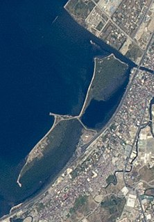
The Olango Island Group is a group of islands found in the Central Visayas region of the Philippines. It comprises Olango island and 6 satellite islets namely: Caubian, Camungi, Caohagan, Gilutongan, Nalusuan, Pangan-an, and Sulpa. The island group has a total land area of approximately 1,030 hectares. It is divided under the jurisdiction of the city of Lapu-Lapu and the municipality of Cordova, Cebu. It lies 5 kilometers (3.1 mi) east of Mactan and is a major tourist destination in Cebu. It is known for its wildlife sanctuary. The entire area is the first declared Ramsar Wetland Site in the Philippines, as recognized in 1994.

Great Santa Cruz Island is a small inhabited island in Zamboanga City in the southern region of the Philippines that is famous for its pink coralline sand. The island, located 4 kilometres (2.49 mi) south of downtown at the Santa Cruz Bank in the Basilan Strait, boasts one of the pink sand beaches in the Philippines. The color of the sand comes from the pulverized red organ pipe coral from eons of surf erosion mixed with the white sand.

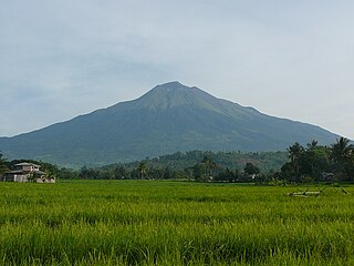
The Mounts Iglit–Baco National Park is a protected area of the Philippines and an ASEAN Heritage Park located in the island of Mindoro in central Philippines. The park covers an area of 75,445 hectares surrounding Mount Iglit and Mount Baco in the central interior of Mindoro. It was established in 1970 by virtue of Republic Act No. 6148. In 2003, the Association of Southeast Asian Nations listed it as one of its four heritage parks in the Philippines. The park has also been nominated in the Tentative List of UNESCO World Heritage Sites.

Angel Chua Alcala,, is a Filipino biologist who was named a National Scientist of the Philippines in 2014. Alcala is known for his fieldwork to build sanctuaries and to promote biodiversity in the aquatic ecosystems of the Philippines. He is currently Chairman of the Board of Advisers at the Angelo King Center for Research and Environmental Management located in Silliman University. Responsible for publishing more than 200 peer-reviewed articles and books, his biological contributions to the environment and ecosystems have made him a renowned hero for natural sciences in the Philippines.
Negros is the fourth largest and third most populous island in the Philippines, with a total land area of 13,309 km2 (5,139 sq mi). Negros is one of the many islands of the Visayas, in the central part of the country. The predominant inhabitants of the island region are mainly called Negrenses. As of 2020 census, the total population of Negros is 4,656,945 people.
Bulubadiangan Island is a privately owned island in northeastern Iloilo, Philippines. It is part of barangay Polopińa, Concepcion. The Sandbar Island Beach Resort on Bulubadiangan is moderately known within the Philippines.
The Las Piñas–Parañaque Critical Habitat and Ecotourism Area (LPPCHEA), also known as the Las Piñas–Parañaque Wetland Park, is a protected area at the coasts of the cities of Las Piñas and Parañaque in Metro Manila, Philippines. The entire wetland is a declared Ramsar site under the Ramsar Convention of UNESCO.

Pulo Island, commonly known as Isla Pulo, is a long, narrow island surrounded by mudflats in the Manila Bay coast of Navotas, about 13 kilometers (8.1 mi) north of Manila in the Philippines. It is a sitio in Barangay Tanza, connected to the mainland of Navotas by a 500-meter-long (1,600 ft) bamboo bridge. The island is known for its mangroves for which it was declared a "marine tree park" and as one of four ecotourism sites in Metro Manila established under the National Ecotourism Strategy in 1999. In 2014, it was home to a resettlement site of about 137 indigent families that mostly occupied the island's southern tip.
Biosphere reserves are areas comprising terrestrial, marine and coastal ecosystems. The biosphere reserve title is handed over by UNESCO. Each reserve promotes solutions reconciling the conservation of biodiversity with its sustainable use. Biosphere reserves are 'Science for Sustainability support sites' – special places for testing interdisciplinary approaches to understanding and managing changes and interactions between social and ecological systems, including conflict prevention and management of biodiversity. Biosphere reserves are nominated by national governments and remain under the sovereign jurisdiction of the states where they are located. Their status is internationally recognized.
