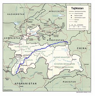
The Vakhsh, also known as the Surkhob, in north-central Tajikistan, and the Kyzyl-Suu, in Kyrgyzstan, is a Central Asian river, and one of the main rivers of Tajikistan. It is a tributary of the Amu Darya river.

The Gandaki River, also known as the Narayani and Gandak, is one of the major rivers in Nepal and a left-bank tributary of the Ganges in India. Its total catchment area amounts to 46,300 km2 (17,900 sq mi), most of it in Nepal. In the Nepal Himalayas, the Gandaki is notable for its deep canyon. The basin also contains three mountains over 8,000 m (26,000 ft), namely Dhaulagiri, Manaslu and Annapurna Massif. Dhaulagiri is the highest point of the Gandaki basin.
The Nam Ngum Dam is a hydroelectric dam on the Nam Ngum River, a major tributary of the Mekong River in Laos. It was the first hydropower dam built in the Lao PDR.

The Kosi or Koshi is a transboundary river which flows through China, Nepal and India. It drains the northern slopes of the Himalayas in Tibet and the southern slopes in Nepal. From a major confluence of tributaries north of the Chatra Gorge onwards, the Kosi River is also known as the Saptakoshi for its seven upper tributaries. These include the Tamur River originating from the Kanchenjunga area in the east and Arun River and the Sun Kosi from Tibet. The Sun Koshi's tributaries from east to west are the Dudh Koshi, Likhu Khola, Tamakoshi River, Bhote Koshi and Indravati. The Saptakoshi crosses into northern Bihar, India where it branches into distributaries before joining the Ganges near Kursela in Katihar district. The Kosi is the third-largest tributary of the Ganges by water discharge after the Ghaghara and the Yamuna.

Besishahar is a municipality and the district headquarters of Lamjung District in Gandaki Province, Nepal. The Besishahar Municipality was formed by merging the existing Village Development Committees i.e. Besishahar, Gaunshahar, Udipur, Chandisthan, Baglungpani, Bajhakhet, Hiletaksar and Chiti and have 11 wards. This municipality has a sub-tropical climate with deciduous forests. Annapurna II, Machhapuchhre, Lamjung Himal can be viewed from north of Besishahar Municipality.
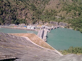
Kaligandaki A Hydroelectric Power Station is situated near Mirmi of Syangja District about 300 km to the west of Kathmandu and 100 km from Pokhara in the same direction in Nepal. The hydropower project is also the biggest hydropower project of Nepal. The dam and headworks are situated on the Gandaki River at the confluence of the Andhikhola whereas the power house is located downstream, around a bend in the river, in Beltari. A 5.9 km (3.7 mi) long headrace tunnel connects the reservoir to the power station which contains three 48 MW Francis turbine-generators. Owner and operator of the power plant is Nepal Electricity Authority.
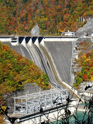
The Hatanagi-I is a dam on the Ōi River in Aoi-ku, Shizuoka, Shizuoka Prefecture on the island of Honshū, Japan. With a height of 125 metres (410 ft), it is the tallest hollow-core concrete gravity dam in the world. It has a hydroelectric power generating station owned by the Chubu Electric Power Company. It supports a 137 megawatts (184,000 hp) pumped-storage hydroelectric power station.
The Kamala River originates in Nepal and flows through the Indian state of Bihar.
The Sambor Dam is a proposed dam and hydroelectric power station on the Mekong River south of Sambor village in Prek Kampi District, Kratie Province, Cambodia. If built, it would be the lowest dam of the Mekong's mainstream dams, and largest in Cambodia.
The West Seti Dam is a proposed hydroelectric dam on the Seti River in the Far-Western Development Region of Nepal. The power station would be located approximately 63 kilometres (39 mi) upstream of the Seti River confluence with the Karnali River, with the dam site located a further 19.2 kilometres (11.9 mi) upstream. All project sites, excluding the reservoir area and transmission line corridor, are located in either Doti and/or Dadeldhura Districts. The reservoir area is located in Doti, Dadeldhura, Baitadi and Bajhang Districts. The transmission line corridor is located in Doti, Dadeldhura, Kailali and Kanchanpur districts.

The Marshyangdi is a mountain river in Nepal. Its length is about 150 kilometres.
Upper marsyangdi A Hydroelectric Station is a run-of-river hydro-electric plant located in Bhulbhule of Lamjung district of western Nepal. The flow from Marshyangdi River is used to generate 50 MW electricity. The energy is evacuated by a 25 km long, 132 kv single circuit transmission line from Bhulbhule (powerhouse) to Middle Marsyangdi Hydropower Project.

Modi River or Modi Khola is a tributary of Gandaki River in Parbat district of Nepal. It is a snow-fed perennial river originating from Annapurna Mountains and has a catchment area of 675 km². It meets the Kali Gandaki River at Modi Beni of Parbat District. The total length of the river is approximately 50km. The main tributaries of the Modi river are Bhurangdi Khola, Rati Khola, Pati Khola, Malyangdi Khola, Ghandruk Khola and Ambote Khola. The mean annual precipitation in the basin is approximately 2,700mm and 80% of the total annual rainfall occurs during the monsoon.
Daraundi A Hydropower Station is a 6 MW run-of-river hydro-electric plant located on the Daraundi River in the Gorkha District of Nepal.
Daram Khola-A Hydropower Station is a run-of-the-river hydroelectricity plant located in Baglung District of Nepal. The flow from Daram River is used to generate 2.5 MW electricity.
Upper Mai-C Hydropower Station is a 6.1 MW run-of-river hydro-electric plant located in the Ilam District of Nepal. It is powered by water from the Mai Khola.
Rudi A Hydropower Station is a run-of-river hydro-electric plant located in the Kaski District of Nepal that came into operation in 2019. The flow from the Rudi River is used to generate 8.8 MW electricity.
The Rudi River, or Rudi Khola is a river in Nepal, a left tributary of the Madi River.
The Chhandi River, or Chhandi Khola is a river in Nepal, a tributary of the Dordi River.
The Mai Khola is a river in eastern Nepal, the headwater of the Kankai River. Its water is used for irrigation and also powers several hydroelectric plants.
