Daresbury was a Mersey flat that is now in a ruinous condition. It lies, partly submerged, in Sutton Lock on River Weaver in Cheshire, England. The lock and its contents are designated as a Scheduled Ancient Monument.
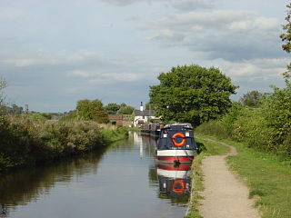
Mersey flats were sailing barges that were used in the inland waterways of Northwest England. They were carvel-built with rounded bilges and sterns, and had a shallow draught. As originally built, the flats had a single mast that could be lowered or lifted out. Typically they were about 70 feet (21.3 m) long by 14 feet (4.3 m) wide. Some flats were larger and could be used as small coasters. Other flats were unrigged and were designed to be pulled by horses or tugs, but strong enough to survive conditions on the river estuaries. The waterways in which the flats were used were the rivers Mersey, Dee and Weaver, and canals and navigations such as the Bridgewater Canal, the Sankey Canal, the Mersey and Irwell Navigation, the Weaver Navigation, the Rochdale Canal, the Chester Canal and the Leeds and Liverpool Canal. [1]
The Daresbury was constructed in 1772 by a boat builder named Samuel Edwards. By 1792–96 she was employed on the Weaver Navigation carrying coals. It is thought that she was lengthened in the early 1800s. At some time in the 19th century, possibly in 1864, she was converted into a floating derrick. Repairs were carried out on the vessel in 1926 and in 1934, and she was still afloat in 1956. She was moved to Sutton Locks on the River Weaver in 1985 and sunk. Plans were made to recover and restore her and to move her to the National Waterways Museum at Ellesmere Port, but these were found to be impractical and were abandoned. [2]
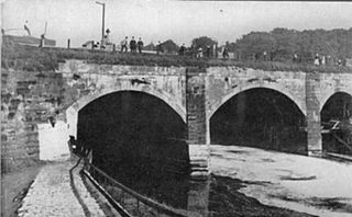
The flat lies partly submerged towards the west end of Sutton Lock, with part of the hull above the water line. [2] The barge measures 17.5 metres (57.4 ft) long by 4.88 metres (16.0 ft) long. The hold, about 9 metres (29.5 ft) long, is full of water. Also partly submerged, about 9 metres (29.5 ft) from the projected position of the bow of the barge, are some metal objects and a piece of timber, which are thought to have come from the Daresbury. [2]
The Daresbury was designated as a Scheduled Ancient Monument on 21 March 2014. [2] Scheduling gives legal protection to an archaeological site that is considered to be of national importance. [3] In the reasons given for scheduling, Daresbury is described as being "the only known pre-1840 survival of a once widespread regional sailing vessel". [2] It has survived reasonably well and has retained a number of key characteristics, and has the potential for providing insight into the construction of boats in the 18th century. There is also "abundant contemporary documentation" about this particular vessel. [2] The area covered by the scheduling is the whole of Sutton Lock, an area measuring a maximum of 37 metres (121.4 ft) by 7 metres (23.0 ft); this is to ensure that any fixtures from the vessel that have been detached are also included. [2]
The Trent and Mersey Canal is a 93+1⁄2-mile (150 km) canal in Derbyshire, Staffordshire and Cheshire in north-central England. It is a "narrow canal" for the vast majority of its length, but at the extremities to the east of Burton upon Trent and north of Middlewich, it is a wide canal.

A lock is a device used for raising and lowering boats, ships and other watercraft between stretches of water of different levels on river and canal waterways. The distinguishing feature of a lock is a fixed chamber in which the water level can be varied; whereas in a caisson lock, a boat lift, or on a canal inclined plane, it is the chamber itself that rises and falls.

The River Mersey is a river in the North West of England. Its name is derived from Old English and means "boundary river", possibly referring to its having been a border between the ancient kingdoms of Mercia and Northumbria. For centuries it has formed part of the boundary between the historic counties of Lancashire and Cheshire.

The Bridgewater Canal connects Runcorn, Manchester and Leigh, in North West England. It was commissioned by Francis Egerton, 3rd Duke of Bridgewater, to transport coal from his mines in Worsley to Manchester. It was opened in 1761 from Worsley to Manchester, and later extended from Manchester to Runcorn, and then from Worsley to Leigh.

The River Weaver is a river, navigable in its lower reaches, running in a curving route anti-clockwise across west Cheshire, northern England. Improvements to the river to make it navigable were authorised in 1720 and the work, which included eleven locks, was completed in 1732. An unusual clause in the enabling Act of Parliament stipulated that profits should be given to the County of Cheshire for the improvement of roads and bridges, but the navigation was not initially profitable, and it was 1775 before the first payments were made. Trade continued to rise, and by 1845, over £500,000 had been given to the county.

The Shropshire Union Canal, nicknamed the "Shroppie", is a navigable canal in England. The Llangollen and Montgomery canals are the modern names of branches of the Shropshire Union (SU) system and lie partially in Wales.
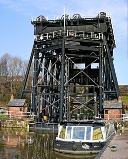
The Anderton Boat Lift is a two caisson lift lock near the village of Anderton, Cheshire, in North West England. It provides a 50-foot (15.2 m) vertical link between two navigable waterways: the River Weaver and the Trent and Mersey Canal. The structure is designated as a scheduled monument, and is included in the National Heritage List for England; it is also known as one of the Seven Wonders of the Waterways.

The Sankey Canal in North West England, initially known as the Sankey Brook Navigation and later the St Helens Canal, is a former industrial canal, which when opened in 1757 was England's first of the Industrial revolution, and the first modern canal.
Runcorn Docks, originally the Bridgewater Docks, is an inland port on the Manchester Ship Canal in the town of Runcorn, Cheshire, England. It is operated by Peel Ports and handles bulk and project cargo.

A Mersey flat is a type of doubled-ended barge with rounded bilges, carvel build and fully decked. Traditionally, the hull was built of oak and the deck was pitch pine. Some had a single mast, with a fore-and-aft rig, while some had an additional mizzen mast. Despite having a flat bottom and curved sides, they were quite stable. They were common from the 1730s to 1890s.
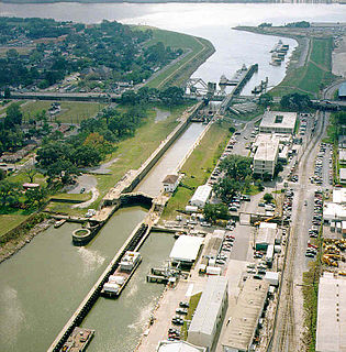
The Inner Harbor Navigation Canal Lock—commonly known as Industrial Canal Lock or simply Industrial Lock—is a navigation lock in New Orleans. It connects the Lower Mississippi River to the Industrial Canal and other sea-level waterways. Because it is shorter and narrower than most modern locks on the Mississippi River System, the 1920s vintage lock has become a bottleneck between the nation's two highest-tonnage waterways—the Mississippi and the Gulf Intracoastal Waterway.

A large number of canals were built in Cheshire, England, during the early phases of the Industrial Revolution to transport goods and raw materials. This resulted in a significant canal network which is now enjoyed by holiday-makers, anglers, walkers, and others.
This is a list of places of interest in Cheshire, England. See List of places in Cheshire for a list of settlements in the county.

The Runcorn and Weston Canal was a short canal near Runcorn in Cheshire, England, constructed to link the Weston Canal, which is part of the River Weaver Navigation, to the Bridgewater Canal and Runcorn Docks. It was completed in 1859, but was little used. Around half of it became the Arnold Dock in 1876, when it was made wider and deeper, and linked to Fenton Dock by a ship lock. The dock section and some of the remaining canal were filled in during the 1960s, and the remainder is in a derelict state.

The Mersey and Irwell Navigation was a river navigation in North West England, which provided a navigable route from the Mersey estuary to Salford and Manchester, by improving the course of the River Irwell and the River Mersey. Eight locks were constructed between 1724 and 1734, and the rivers were improved by the construction of new cuts several times subsequently. Use of the navigation declined from the 1870s, and it was ultimately superseded by the Manchester Ship Canal, the construction of which destroyed most of the Irwell section of the navigation and the long cut between Latchford and Runcorn.

Runcorn is an industrial town in the borough of Halton, Cheshire, England. This list contains the 27 buildings that are recorded in the National Heritage List for England as designated listed buildings in the part of the borough lying to the south of the River Mersey outside the urban area of Runcorn. The area covered includes the villages of Clifton, Daresbury, Preston Brook, Preston on the Hill, and Moore. Three of the buildings in the area are classified as Grade II*, and the others are at Grade II; there are no buildings in Grade I. In the United Kingdom, the term listed building refers to a building or other structure officially designated as being of special architectural, historical, or cultural significance. These buildings are in three grades: Grade I consists of buildings of outstanding architectural or historical interest; Grade II* includes particularly significant buildings of more than local interest; Grade II consists of buildings of special architectural or historical interest. Buildings in England are listed by the Secretary of State for Culture, Media and Sport on recommendations provided by English Heritage, which also determines the grading.

The Hulme Locks Branch Canal is a canal in the city of Manchester. It is 200m in length and was built to provide a direct waterway between the Mersey and Irwell Navigation and the Bridgewater Canal. The canal opened in 1838 and was superseded in 1995 by a new lock at Pomona Dock 3. As both of its locks remain closed, the canal is now overgrown.
Dutton is a civil parish in Cheshire West and Chester, England. It contains the village of Dutton, but is otherwise rural. Important transport links pass through the parish. The West Coast Main Line runs through in a north–south direction. Dutton Viaduct and the Weaver Junction are in the parish. The Trent and Mersey Canal runs through it in a northwest–southeast direction, and enters the south portal of the Preston Brook Tunnel. The A533 road traverses the parish in a similar direction. In the southern part of the parish, running east–west, is the River Weaver and the Weaver Navigation. Included in the parish are 22 buildings that are recorded in the National Heritage List for England as designated listed buildings. Some of the buildings are houses, and others are associated with the Trent and Mersey Canal and the Weaver Navigation.
The Barton Aqueduct, opened on 17 July 1761, carried the Bridgewater Canal over the River Irwell at Barton-upon-Irwell, in the historic county of Lancashire, England. Designed largely by James Brindley under the direction of John Gilbert, it was the first navigable aqueduct to be built in England, "one of the seven wonders of the canal age" according to industrial archaeologist Mike Nevell.

A widebeam is a canal boat built in the style of a British narrowboat but with a beam of 2.16 metres or greater.