Dargan Bridge, Belfast

Last updated

Steam train on Dargan Bridge, December 2008 Santa steam, Belfast - geograph.org.uk - 1080045.jpg
Steam train on Dargan Bridge, December 2008

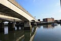
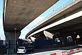
Dargan Bridge is a railway bridge which crosses the River Lagan in Belfast, Northern Ireland. Opened in 1994, it directly connected the Newry and Bangor lines with the lines to Larne and Derry for the first time. It is named after the Irish railway engineer William Dargan and is the longest bridge on the island of Ireland. [1]

Contents

Next bridge upstream River Lagan Next bridge downstream
Lagan Weir Dargan Bridge M3 Lagan Bridge

History

Northern Ireland Railways first proposed what was then called the 'Cross Harbour Link' in 1978. Construction was scheduled to begin in 1980, however the project was cancelled by the direct rule government in 1979. [2] The scheme was later revived and was included in the urban area plan which was published in 1990. [3] In preparation for the new line, Yorkgate station was opened on 17 October 1992, replacing York Road Station. The bridge was then constructed and opened to traffic on 28 November 1994. It was officially opened by Elizabeth II on 9 March 1995. [4]

Structure

Dargan Bridge is a concrete viaduct 4,675 feet (1,425 m) in length and is parallel to Lagan Bridge. It carries a single-track railway, which has a passing loop as it crosses Corporation Street. There was planned to be a station here called Donegall Quay, which was originally due to open in 1997, but so far it has not been built. [2]

See also

Related Research Articles

<span class="mw-page-title-main">River Lagan</span> River in Northern Ireland

The River Lagan is a major river in Northern Ireland which runs 53.5 mi (86.1 km) from the Slieve Croob mountain in County Down to Belfast where it enters Belfast Lough, an inlet of the Irish Sea. The Lagan forms much of the border between County Antrim and County Down in the east of Ulster. It rises as a tiny, fast-moving stream near to the summit of Slieve Croob; Transmitter Road runs nearby. It runs to Belfast through Dromara, Donaghcloney and Dromore. On the lower slopes of the mountain, it combines with a branch from Legananny Mountain, just opposite Slieve Croob. The river then turns east to Magheralin into a broad plain between the plateaus of Antrim and Down.

<span class="mw-page-title-main">Northern Counties Committee</span> Railway in Northern Ireland (1903–1949)

The Northern Counties Committee (NCC) was a railway that served the north-east of Ireland. It was built to Irish gauge but later acquired a number of 914 mm narrow gauge lines. It had its origins in the Belfast and Ballymena Railway which opened to traffic on 11 April 1848.

<span class="mw-page-title-main">York Road railway station</span> Former station in Belfast, Northern Ireland

York Road railway station served the north of Belfast in Northern Ireland. It was formerly one of the three terminus railway stations in Belfast. The others were Great Victoria Street, and Queen's Quay.

<span class="mw-page-title-main">M1 motorway (Northern Ireland)</span> Motorway in Northern Ireland connecting Belfast and Dungannon

The M1 is a motorway in Northern Ireland. It is the longest motorway in Northern Ireland and runs for 38 miles (61 km) from Belfast to Dungannon through County Antrim, County Down, County Armagh and County Tyrone. It forms part of the route via the A1 in Northern Ireland between Belfast and Dublin as well as being a part of the unsigned European E01 and E18 routes.

<span class="mw-page-title-main">Belfast Lough</span> Large, intertidal sea inlet on the east coast of Northern Ireland

Belfast Lough is a large, intertidal sea inlet on the east coast of Northern Ireland. At its head is the city and port of Belfast, which sits at the mouth of the River Lagan. The lough opens into the North Channel and connects Belfast to the Irish Sea.

<span class="mw-page-title-main">Ballymacarrett</span> Townland/electoral ward in Belfast, Northern Ireland

Ballymacarrett or Ballymacarret is the name of both a townland and electoral ward in Belfast. The townland is in County Down and the electoral ward is part of the Titanic district electoral area of Belfast City Council.

<span class="mw-page-title-main">M3 motorway (Northern Ireland)</span> Motorway in Northern Ireland

The M3 is an urban motorway 0.8 miles (1.3 km) in length owned by Siac Construction and Cintra, S.A. that connects the M2 in north Belfast, Northern Ireland to the A2 Sydenham Bypass in east Belfast. It is the shortest motorway in Northern Ireland, and one of the busiest, carrying 60,000 vehicles per day as of 2005. It has a permanent speed limit of 50 mph (80 km/h).

<span class="mw-page-title-main">Derry ~ Londonderry railway station</span> Railway station in Northern Ireland

Derry ~ Londonderry railway station, also known as North West Transport Hub or Waterside railway station, is a railway terminus in Derry, Northern Ireland, on the east bank of the River Foyle, operated by Northern Ireland Railways and its 8th biggest station across the network with 723,776 passengers in the 22/23 year. It is on the Belfast–Derry railway line, terminating at Belfast Great Victoria Street.

<span class="mw-page-title-main">Lagan Weir</span>

The Lagan Weir, in Belfast, Northern Ireland, crosses the River Lagan between the Queen Elizabeth Bridge and the M3 cross-harbour bridge. Prior to the building of the weir, the river would be subject to tidal fluctuations, and low tide would expose mudflats, which were unsightly and emitted a strong odour, particularly in the summer months. Opened in 1994, the weir was seen by the Laganside Corporation as a catalyst for its redevelopment projects and was judged to be the "centrepiece" of that effort. The weir also incorporates a footbridge.

<span class="mw-page-title-main">Belfast–Larne line</span> Railway line along Antrim coast, Northern Ireland

The Belfast–Larne line, or Larne line, is a railway line in Northern Ireland, operated by Northern Ireland Railways. It runs as double track along the majority of its route north along the scenic east Antrim coastline from Belfast to the coastal seaport town of Larne, serving commuters and ferry passengers.

<span class="mw-page-title-main">Yorkgate railway station</span> Station in Belfast, Northern Ireland

Yorkgate railway station serves the north of the city of Belfast, Northern Ireland. The station opened in 1992, replacing the previous York Road railway station nearby. As at May 2021 there are plans to rebuild Yorkgate.

<span class="mw-page-title-main">Ulster Canal</span> Disused canal in Ireland

The Ulster Canal is a canal running through part of County Armagh, County Tyrone and County Fermanagh in Northern Ireland and County Monaghan in the Republic of Ireland. The Ulster Canal was built between 1825 and 1842 and was 74 km (46 mi) long with 26 locks. It ran from Charlemont on the River Blackwater to near Wattlebridge on the Finn River, south-east of Upper Lough Erne. It was an ill-considered venture, with the locks built narrower than the other Irish waterways, preventing through trade, and an inadequate water supply. It was an abject failure commercially, and contributed to the collapse of the Lagan Navigation Company, who took it over from the government but were then refused permission to abandon it when they could not afford the maintenance costs. It finally closed in 1931. Waterways Ireland started work on rebuilding the canal at its southern end in 2015.

Giant's Park is a planned public park, in Belfast, Northern Ireland. The proposed 200-acre (0.81 km2) site is the Dargan Road Landfill site on the northern shore of Belfast Lough Its name comes from the nearby Cavehill, which is thought to be the inspiration for Jonathan Swift's Gulliver's Travels. He described the hills as a sleeping giant, safeguarding the city. Planned features of the park include an educational facility and festival space.

<span class="mw-page-title-main">Queen's Quay, Belfast</span>

Queen's Quay is a section of the River Lagan, in the western Titanic Quarter of the city of Belfast, Northern Ireland.

<span class="mw-page-title-main">Lagan Canal</span> Canal between Belfast and Lough Neagh, Northern Ireland

The Lagan Canal was a 44-kilometre (27 mi) canal built to connect Belfast to Lough Neagh. The first section, which is a river navigation, was opened in 1763, and linked Belfast to Lisburn. The second section from Lisburn to Lough Neagh includes a small amount of river navigation, but was largely built as a canal. At its peak it was one of the most successful of the Irish canals, but ultimately it was unable to compete with road and rail transport, and the two sections were closed in 1954 and 1958. The central section from Sprucefield to Moira was destroyed by the construction of the M1 motorway in the 1960s. Responsibility for most of its remains passed first to the Department of Agriculture and then to the Department of Culture, Arts and Leisure, although the section between Aghalee Bridge and Lough Neagh, including the final ten locks, passed into private ownership. There is an active campaign to re-open the canal, including reinstatement of the central section.

<span class="mw-page-title-main">Queen's Quay railway station</span>

Queen's Quay railway station served the east of Belfast in Northern Ireland. It was formerly one of the three terminus railway stations in Belfast. The others were Great Victoria Street, and York Road.

<span class="mw-page-title-main">Lagan Railway Bridge</span> Bridge in Belfast

Lagan Railway Bridge is a railway and pedestrian bridge across the River Lagan in Belfast, slightly north of Belfast Central railway station. The next bridge upstream is the Albert Bridge, whilst the next downstream is Queen's Bridge.

<span class="mw-page-title-main">King's Bridge, Belfast</span>

King's Bridge is a road bridge across the River Lagan in South Belfast, Northern Ireland. It opened in 1912 and is named after King George V. Made of reinforced concrete, it is believed to be the first road bridge of this type in Ireland.

<span class="mw-page-title-main">Shaw's Bridge</span>

Shaw's Bridge is the name given to two adjacent bridges across the River Lagan in Belfast, Northern Ireland. The older of the bridges is a historic stone arched bridge, which is open to cyclists and pedestrians. The new bridge is a concrete bridge which carries the A55 road.

References

  1. Institution of Civil Engineers. "Belfast cross-harbour road and rail bridges" . Retrieved 16 February 2024.
  2. 1 2 Rowledge, J. W. P. (1995). A Regional History of Railways: Volume XVI: Ireland. Penryn: Atlantic Transport Publishers. pp. 221–224. ISBN   090689963X.
  3. "Belfast Urban Area Plan 2001 | Planning Portal". wayback.archive-it.org. Retrieved 16 February 2024.
  4. Johnson, Stephen (1997). Johnson's Atlas and Gazetteer of the Railways of Ireland. Leicester: Midland Publishing Limited. p. 127. ISBN   1857800443.

54°36′9″N5°55′13″W / 54.60250°N 5.92028°W / 54.60250; -5.92028