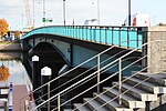
Image Name Date Carries Design Listing Locality Coordinates Notes Lagan Bridge 1995 [ 1] M3 Motorway ConcreteBox girder bridge [ 1] Not listed Belfast 54°36′09.6″N 5°55′11.0″W / 54.602667°N 5.919722°W / 54.602667; -5.919722 Connects the Sydenham Bypass with the M2 foreshore. Dargan Bridge 1994 [ 2] Belfast–Derry railway line Belfast–Larne railway line ConcreteBox girder bridge [ 1] Not listed Belfast 54°36′08.8″N 5°55′12.0″W / 54.602444°N 5.920000°W / 54.602444; -5.920000 Was built to connect all of Northern Ireland's railways into one network. Lagan Weir Footbridge 2015 [ 3] Pedestrians, cyclists SteelBeam bridge Not listed Belfast 54°36′04.4″N 5°55′13.0″W / 54.601222°N 5.920278°W / 54.601222; -5.920278 Replaced earlier bridge which was removed in 2014. Queen Elizabeth Bridge 1966 [ 4] A2 (eastbound) SteelGirder bridge [ 5] Not listed Belfast 54°36′01.0″N 5°55′13.7″W / 54.600278°N 5.920472°W / 54.600278; -5.920472 Queen's Bridge 1843 [ 6] A2 (westbound) StoneArch bridge B+ Belfast 54°35′58.9″N 5°55′13.7″W / 54.599694°N 5.920472°W / 54.599694; -5.920472 Replaced the earlier Long Bridge. Named after Queen Victoria. Lagan Railway Bridge 1976 [ 7] Belfast–Derry railway line Belfast–Larne railway line Belfast–Bangor railway line SteelBeam bridge Not listed Belfast 54°35′51.5″N 5°55′02.2″W / 54.597639°N 5.917278°W / 54.597639; -5.917278 Replaced a single track, wooden bridge built in 1875 Albert Bridge 1890 [ 8] A20 East Bridge Street Cast iron Arch bridge B+ Belfast 54°35′44.9″N 5°54′46.8″W / 54.595806°N 5.913000°W / 54.595806; -5.913000 Replaced a previous bridge which suddenly collapsed. Ormeau Bridge 1863 [ 9] A24 Ormeau Road StoneArch bridge Not listed Belfast 54°34′58.5″N 5°55′19.0″W / 54.582917°N 5.921944°W / 54.582917; -5.921944 Replaced a previous bridge, built in 1809. King's Bridge 1912 [ 10] Eastbound road traffic ConcreteBeam bridge A Belfast 54°34′38.2″N 5°55′42.7″W / 54.577278°N 5.928528°W / 54.577278; -5.928528 One of the first reinforced concrete bridges in Ireland. Named after King George V. Governor's Bridge 1974 [ 11] Westbound road traffic ConcreteBeam bridge Not listed Belfast 54°34′30.1″N 5°55′51.2″W / 54.575028°N 5.930889°W / 54.575028; -5.930889 Named after Ralph Grey, Baron Grey of Naunton , the last Governor of Northern Ireland Stranmillis Weir Private pedestrian access Not listed Belfast 54°34′07.0″N 5°55′38.5″W / 54.568611°N 5.927361°W / 54.568611; -5.927361 Lagan Gateway bridge 2021 [ 12] Pedestrians and cyclists between Stranmillis and Annadale Not listed Belfast 54°34′6.7″N 5°55′40.5″W / 54.568528°N 5.927917°W / 54.568528; -5.927917 A new lock was also built under the bridge. The bridge will be named after Noah Donohoe. [ 13] Brown Bridge or Belvoir Bridge [ 14] [ 15] 2023 Pedestrians and cyclists between Belvoir Park Forest and Lagan Towpath WoodenArch bridge Not listed Belfast 54°33′27.4″N 5°56′10.4″W / 54.557611°N 5.936222°W / 54.557611; -5.936222 Original bridge replaced in 2023 due to safety concerns. [ 16] Red Bridge Pedestrians and cyclists on Lagan Towpath National Cycle Route 9 IronBeam bridge Not listed Belfast 54°33′12.1″N 5°56′37.1″W / 54.553361°N 5.943639°W / 54.553361; -5.943639 John Luke Bridge 2013 [ 17] Pedestrians and cyclists on Lagan Towpath National Cycle Route 9 Steel Not listed Belfast 54°33′17.7″N 5°56′57.1″W / 54.554917°N 5.949194°W / 54.554917; -5.949194 Replaced earlier bridge. Named to honour Belfast-born artist John Luke Water Main Not listed Belfast 54°33′17.9″N 5°57′07.2″W / 54.554972°N 5.952000°W / 54.554972; -5.952000 Shaw's Bridge 1977 [ 18] A55 Malone Road ConcreteArch bridge Not listed Belfast 54°33′08.9″N 5°57′09.7″W / 54.552472°N 5.952694°W / 54.552472; -5.952694 Shaw's Bridge 1707 [ 18] Pedestrians and cyclists StoneArch bridge B1 Belfast 54°33′08.1″N 5°57′10.8″W / 54.552250°N 5.953000°W / 54.552250; -5.953000 Carried road traffic prior to the opening of its modern counterpart. Replaced a wooden bridge dating from the early 17th century [ 19] Gilchrist Bridge 1986 Pedestrians and cyclists between Edenderry and Lagan Towpath WoodenArch bridge Not listed Edenderry 54°32′36.6″N 5°57′54.0″W / 54.543500°N 5.965000°W / 54.543500; -5.965000 Named after John Gilchrist, founder of Lagan Valley Regional Park [ 19] Drum Bridge before [ 19] B103 Upper Malone Road StoneArch bridge B1 Drumbeg 54°32′06.5″N 5°58′59.3″W / 54.535139°N 5.983139°W / 54.535139; -5.983139 Pedestrians and cyclists on Lagan Towpath National Cycle Route 9 Truss bridge Not listed Drumbeg 54°32′10.9″N 5°59′02.9″W / 54.536361°N 5.984139°W / 54.536361; -5.984139 1962 M1 Motorway ConcreteBox girder bridge Not listed Drumbeg 54°32′34.5″N 5°59′37.3″W / 54.542917°N 5.993694°W / 54.542917; -5.993694 Private access to house Not listed Derriaghy 54°32′20.3″N 6°00′12.5″W / 54.538972°N 6.003472°W / 54.538972; -6.003472 Rambler's Bridge [ 20] Pedestrians and cyclists between Seymour Hill estate and Lagan Towpath Truss bridge Not listed Derriaghy 54°32′15.5″N 6°00′23.8″W / 54.537639°N 6.006611°W / 54.537639; -6.006611 Wolfenden's Bridge before [ 19] B103 Ballyskeagh Road StoneArch bridge B+ Lambeg 54°32′00.0″N 6°01′02.7″W / 54.533333°N 6.017417°W / 54.533333; -6.017417 Lambeg Bridge Tullynacross Road StoneArch bridge Not listed Lambeg 54°31′42.8″N 6°01′27.7″W / 54.528556°N 6.024361°W / 54.528556; -6.024361 Pedestrians and cyclists SteelBeam bridge Not listed Lambeg 54°31′42.5″N 6°01′28.0″W / 54.528472°N 6.024444°W / 54.528472; -6.024444 Hilden Bridge Bridge Street StoneArch bridge Not listed Hilden 54°31′18.8″N 6°01′19.3″W / 54.521889°N 6.022028°W / 54.521889; -6.022028 Mid 1900s [ 21] Single story building spanning the river on reinforced concrete beams B+ (as part of mill complex)
Hilden 54°31′13.4″N 6°01′18.0″W / 54.520389°N 6.021667°W / 54.520389; -6.021667 Gutted by fire in 2006 Access within former Hilden Mill complex (bridge disused) B+ (as part of mill complex)
Hilden 54°31′12.3″N 6°01′17.1″W / 54.520083°N 6.021417°W / 54.520083; -6.021417 1896 [ 22] Pedestrians within former Hilden Mill complex (bridge disused) Iron Lattice girder bridge
B2 Hilden 54°31′05.0″N 6°01′21.5″W / 54.518056°N 6.022639°W / 54.518056; -6.022639 Private pedestrian access over weir Not listed Lisburn 54°30′52.1″N 6°01′26.4″W / 54.514472°N 6.024000°W / 54.514472; -6.024000 Blue Bridge [ 15] Pedestrians and cyclists ConcreteCantilever bridge Not listed Lisburn 54°30′48.9″N 6°01′27.2″W / 54.513583°N 6.024222°W / 54.513583; -6.024222 2002 Pedestrian and cyclist access to Lagan Valley Island SteelTruss bridge Not listed Lisburn 54°30′44.1″N 6°02′05.0″W / 54.512250°N 6.034722°W / 54.512250; -6.034722 Queen's Bridge 2002 Road traffic access to Lagan Valley Island ConcreteBeam bridge Not listed Lisburn 54°30′42.3″N 6°02′11.6″W / 54.511750°N 6.036556°W / 54.511750; -6.036556 Union Bridge 1880 [ 19] A49 Sloan Street StoneArch bridge Not listed Lisburn 54°30′35.8″N 6°02′17.6″W / 54.509944°N 6.038222°W / 54.509944; -6.038222 Replaced earlier bridge Water pipe Not listed Lisburn 54°30′32.0″N 6°02′25.1″W / 54.508889°N 6.040306°W / 54.508889; -6.040306 Moore's Bridge 1825 [ 19] A1 Hillsborough Road SandstoneArch bridge B1 Lisburn 54°29′55.6″N 6°03′08.2″W / 54.498778°N 6.052278°W / 54.498778; -6.052278 Pedestrians and cyclists on Lagan Towpath National Cycle Route 9 SteelArch bridge Not listed Lisburn 54°29′51.6″N 6°03′22.5″W / 54.497667°N 6.056250°W / 54.497667; -6.056250 Young's Bridge Halftown Road Not listed Lisburn 54°30′01.4″N 6°05′50.8″W / 54.500389°N 6.097444°W / 54.500389; -6.097444 Maze Bridge Gravehill Road Stone Arch bridge
Not listed Mazetown 54°29′42.3″N 6°06′58.4″W / 54.495083°N 6.116222°W / 54.495083; -6.116222 The New Bridge Cockhill Road Not listed Halfpenny Gate 54°29′07.8″N 6°08′47.2″W / 54.485500°N 6.146444°W / 54.485500; -6.146444 Spencer's Bridge 1840-1859 [ 23] Hillsborough Road Stone Arch bridge
B1 Moira 54°28′38.8″N 6°10′33.1″W / 54.477444°N 6.175861°W / 54.477444; -6.175861 M1 Motorway Not listed Moira 54°28′35.5″N 6°11′22.0″W / 54.476528°N 6.189444°W / 54.476528; -6.189444 Newmill Bridge 1740-1759 [ 24] Clarehill Road Stone Arch bridge
B2 Moira 54°28′26.8″N 6°12′20.9″W / 54.474111°N 6.205806°W / 54.474111; -6.205806 Steps Bridge Steps Road Not listed Magheralin 54°27′48.2″N 6°14′48.5″W / 54.463389°N 6.246806°W / 54.463389; -6.246806 Forge Bridge [ 25] B9 New Forge Road Stone Arch bridge
B2 Magheralin 54°27′31.5″N 6°15′34.2″W / 54.458750°N 6.259500°W / 54.458750; -6.259500 Geehan's Bridge [ 26] B2 Dromore Road Stone Arch bridge
B1 Waringstown 54°26′41.1″N 6°16′21.6″W / 54.444750°N 6.272667°W / 54.444750; -6.272667 Banoge Bridge [ 27] Hall Road Stone Arch bridge
B2 Donaghcloney 54°25′14.3″N 6°16′12.6″W / 54.420639°N 6.270167°W / 54.420639; -6.270167 Pedestrians to former Ewart Liddell Weaving Factory (bridge disused) Not listed Donaghcloney 54°24′52.4″N 6°15′36.6″W / 54.414556°N 6.260167°W / 54.414556; -6.260167 Donaghcloney Bridge B9 Main Street Stone Arch bridge
Not listed Donaghcloney 54°24′55.9″N 6°15′24.3″W / 54.415528°N 6.256750°W / 54.415528; -6.256750 Thornyford Bridge 1760-1779 [ 28] Blackskull Road Stone Arch bridge
B1 Gamblestown 54°25′18.5″N 6°12′54.6″W / 54.421806°N 6.215167°W / 54.421806; -6.215167 Gillhall Bridge 1670s [ 29] Private access to farm Stone Arch bridge
B+ Dromore 54°25′00.0″N 6°12′11.4″W / 54.416667°N 6.203167°W / 54.416667; -6.203167 Was built to provide access to Gill Hall mansion. The house was built at the same time as the bridge and was said to be haunted. It burnt down in 1969. Private access to farmland Not listed Dromore 54°25′01.4″N 6°11′05.2″W / 54.417056°N 6.184778°W / 54.417056; -6.184778 Private access to B&B Not listed Dromore 54°24′52.2″N 6°10′18.3″W / 54.414500°N 6.171750°W / 54.414500; -6.171750 1972 [ 30] A1 Dromore Bypass Not listed Dromore 54°24′50.1″N 6°09′40.3″W / 54.413917°N 6.161194°W / 54.413917; -6.161194 Dromore Viaduct Early 1860s [ 31] Trackbed of the former Banbridge, Lisburn and Belfast Junction Railway Stone Viaduct
B+ Dromore 54°24′49.2″N 6°09′38.7″W / 54.413667°N 6.160750°W / 54.413667; -6.160750 Disused since the railway closed in 1956 Pedestrians in Dromore Park Not listed Dromore 54°24′45.3″N 6°09′31.6″W / 54.412583°N 6.158778°W / 54.412583; -6.158778 Pedestrians in Dromore Park Not listed Dromore 54°24′46.3″N 6°09′26.3″W / 54.412861°N 6.157306°W / 54.412861; -6.157306 Regent Bridge 1811 [ 32] B2 Banbridge Road Stone Arch bridge
B1 Dromore 54°24′51.4″N 6°09′04.7″W / 54.414278°N 6.151306°W / 54.414278; -6.151306 Downshire Bridge 1885 [ 33] Bridge Street Stone Arch bridge
B2 Dromore 54°24′50.3″N 6°08′58.7″W / 54.413972°N 6.149639°W / 54.413972; -6.149639 Caughey's Road Not listed Dromore 54°24′34.9″N 6°07′20.5″W / 54.409694°N 6.122361°W / 54.409694; -6.122361 Lurganbane Road Not listed Dromore 54°24′21.4″N 6°05′49.1″W / 54.405944°N 6.096972°W / 54.405944; -6.096972 Lagangreen Bridge Lagangreen Road Not listed Kinallen 54°24′09.4″N 6°04′48.7″W / 54.402611°N 6.080194°W / 54.402611; -6.080194 1800-1819 [ 34] Black Bog Road Stone Arch bridge
B1 Kinallen 54°23′52.4″N 6°04′25.1″W / 54.397889°N 6.073639°W / 54.397889; -6.073639 Kinallen Road Not listed Kinallen 54°23′34.1″N 6°04′03.7″W / 54.392806°N 6.067694°W / 54.392806; -6.067694 Artanagh Road Not listed Kinallen 54°23′11.5″N 6°02′42.6″W / 54.386528°N 6.045167°W / 54.386528; -6.045167 1780- 1799 [ 35] Dromore Road B2 Dromara 54°23′08.8″N 6°02′07.6″W / 54.385778°N 6.035444°W / 54.385778; -6.035444 1800-1819 [ 36] Banbridge Road Stone Arch bridge
Not listed Dromara 54°22′47.9″N 6°01′12.9″W / 54.379972°N 6.020250°W / 54.379972; -6.020250 Moybrick Road Not listed Dromara 54°22′39.6″N 6°01′25.3″W / 54.377667°N 6.023694°W / 54.377667; -6.023694 Private access to farmland Not listed Dromara 54°22′39.1″N 6°01′14.8″W / 54.377528°N 6.020778°W / 54.377528; -6.020778 Bell's Bridge 1800-1819 [ 37] B7 Rathfriland Road Stone Arch bridge
B2 Dromara 54°22′13.8″N 6°01′06.7″W / 54.370500°N 6.018528°W / 54.370500; -6.018528 1800-1819 [ 38] Dree Hill (road) Stone Arch bridge
Not listed Finnis 54°21′44.4″N 6°01′26.0″W / 54.362333°N 6.023889°W / 54.362333; -6.023889 Private access to farm Not listed Finnis 54°21′20.6″N 6°00′59.8″W / 54.355722°N 6.016611°W / 54.355722; -6.016611 Dree Hill (road) Not listed Finnis 54°21′14.7″N 6°00′49.0″W / 54.354083°N 6.013611°W / 54.354083; -6.013611