York Road railway station served the north of Belfast in Northern Ireland. It was formerly one of the three terminus railway stations in Belfast. The others were Great Victoria Street, and Queen's Quay.

The M1 is a motorway in Northern Ireland. It is the longest motorway in Northern Ireland and runs for 38 miles (61 km) from Belfast to Dungannon through County Antrim, County Down, County Armagh and County Tyrone. It forms part of the route via the A1 in Northern Ireland between Belfast and Dublin as well as being a part of the unsigned European E01 and E18 routes.

The M3 is an urban motorway 0.8 miles (1.3 km) in length owned by Siac Construction and Cintra, S.A. that connects the M2 in north Belfast, Northern Ireland to the A2 Sydenham Bypass in east Belfast. It is the shortest motorway in Northern Ireland, and one of the busiest, carrying 60,000 vehicles per day as of 2005. It has a permanent speed limit of 50 mph (80 km/h).

The Belfast–Newry line operates from Lanyon Place station in County Antrim to Newry in County Down, Northern Ireland. The manager for this line is based at Portadown railway station, although the line extends to the border to include the Scarva and Poyntzpass halts and Newry. Newry is on the fringe of the network, being the last stop before the border with the Republic of Ireland. The line follows the route of the northern half of the main Dublin–Belfast line, with the exception of calling at Belfast Great Victoria Street.
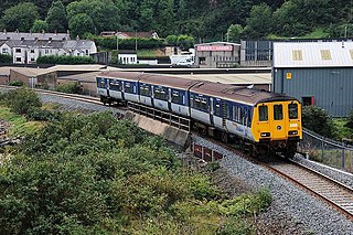
The Belfast–Larne line, or Larne line, is a railway line in Northern Ireland, operated by Northern Ireland Railways. It runs as double track along the majority of its route north along the scenic east Antrim coastline from Belfast to the coastal seaport town of Larne, serving commuters and ferry passengers.
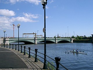
Albert Bridge is a bridge in Belfast, Northern Ireland. Its three flat arches span the River Lagan. It was completed in 1890 by Belfast city surveyor J C Bretland and is named after Prince Albert Victor. It is located close to the city centre between East Bridge Street and the Albertbridge Road.
EWAY is a bus rapid transit route being built in Northern Ireland to link the town of Dundonald in County Down with Belfast City Centre. If completed it will be about 5.5 miles (9 km) long.

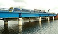
Dargan Bridge, built in the 1990s, is a railway bridge in Belfast, Northern Ireland. This bridge spans the River Lagan and connects the railway lines to Larne and Derry to those east Bangor and south to Newry and the Republic. It runs mostly parallel to the Lagan Bridge carrying the M3 motorway across the Lagan. One of the first people to cross it was Mr John Johnston, the first Station Manager of Belfast Central Station and his grandson James Currie.
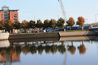
Queen's Quay is a section of the River Lagan, in the western Titanic Quarter of the city of Belfast, Northern Ireland.

The A55 road forms Belfast's outer-ring road.

Quarterbridge is situated soon after the 1 mile-marker measured from the TT Grandstand, part of the Snaefell Mountain Course used for the Isle of Man TT races, at the junction of the primary A1 Douglas to Peel road, A2 Douglas to Ramsey road and the A5 Douglas to Port Erin road which forms the boundary between the parishes of Braddan and Onchan in the Isle of Man.
The Londonderry and Enniskillen Railway (L&ER) was an Irish gauge railway in Ireland.
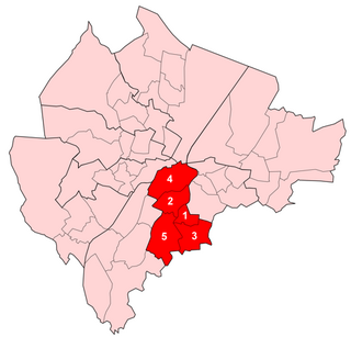
Laganbank was one of the nine district electoral areas in Belfast, Northern Ireland which existed from 1985 to 2014. Located in the south of the city, the district elected five members to Belfast City Council and contained the wards of Ballynafeigh, Botanic, Shaftesbury, Stranmillis, and Rosetta. Laganbank, along with neighbouring Balmoral, formed the greater part of the Belfast South constituencies for the Northern Ireland Assembly and UK Parliament.
The Belfast Urban Motorway was a proposed motorway system in Belfast, Northern Ireland announced in 1964, but was never completed, only the Western portion was built as the A12, Westlink. It was to be built in three phases: Phase 1, from the M1 at Broadway to the M2 at York Street; Phase 2, from the M2 at York Street across the River Lagan to the M3 at the bottom of the Newtownards Road; and Phase 3, from the Newtownards Road south through Short Strand, back across the River Lagan, through Shaftesbury Square to join the start at the M1.

King's Bridge is a road bridge across the River Lagan in South Belfast, Northern Ireland. It opened in 1912 and is named after King George V. Made of reinforced concrete, it is believed to be the first road bridge of this type in Ireland.
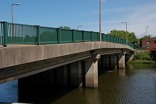
Governor's Bridge is a road bridge in Stranmillis, south Belfast. It was inaugurated on 23 September 1974.

Shaw's Bridge is the name given to two adjacent bridges across the River Lagan in Belfast, Northern Ireland. The older of the bridges is a historic stone arched bridge, which is open to cyclists and pedestrians. The new bridge is a concrete bridge which carries the A55 road.
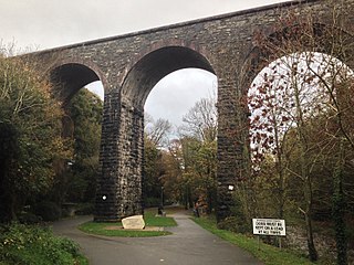
The Dromore Viaduct is an abandoned railway viaduct in Dromore, County Down, Northern Ireland.